Using community science to advance grizzly bear conservation
Abstract
Alberta grizzly bears are classified as a threatened species in the province of Alberta as of 2010, with human-caused mortality and habitat loss a primary threat. The people who live, work, and recreate within bear habitat play a crucial role in their conservation. While the public is often enthusiastic about grizzly bears, and opportunistically report their observations to government staff, these reports are not systematic or rigorously collected and lack key information. As such, we developed GrizzTracker as a community science program. Following several years of successful deployment, we analyzed community scientist data and evaluated the efficacy of the program through an online user survey. We found that the GrizzTracker app was useful as a data collection and public engagement tool, yielding information for applied management, and that community scientists were generally satisfied. We provide considerations for future program development, including considerations for human, social, technological, and financial capital investment related to design, development, and implementation of data collection protocols, the importance of clearly communicating outcomes, and opportunities for educational outreach. While there is continued trepidation by traditionally trained scientists to develop or engage in community science programs, and some noted areas of improvement for our program specifically, we think that GrizzTracker offers a success story in community science.
Introduction
In Alberta, Canada, the distribution of grizzly (brown) bears (Ursus arctos horribilis) overlaps multiple different human land use types, from the south of the province along the Rocky Mountains and foothills, and into the northwestern boreal landscape (Nielsen et al. 2009; Morehouse and Boyce 2016; Hughes et al. 2021). As a result of an increasing human population and related land use, habitat fragmentation and loss, grizzly bears faced increased mortality across the province (Hughes et al. 2020, 2021). This has largely resulted from direct human–bear conflict including retaliatory or accidental killing of grizzlies due to livestock depredation issues, public safety concerns, poaching incidences, or motor vehicle collisions (Alberta Sustainable Resource Development 2008). In response to population concerns, grizzly bears were classified as a threatened species in Alberta in 2010; however, the management of the species has since been hindered by a lack of population data and challenges to implementing recovery policy across the different communities and people expected to live with grizzly bears (Chamberlain et al. 2012; Hughes and Nielsen 2019; Alberta Environment and Parks 2020; Hughes et al. 2020).
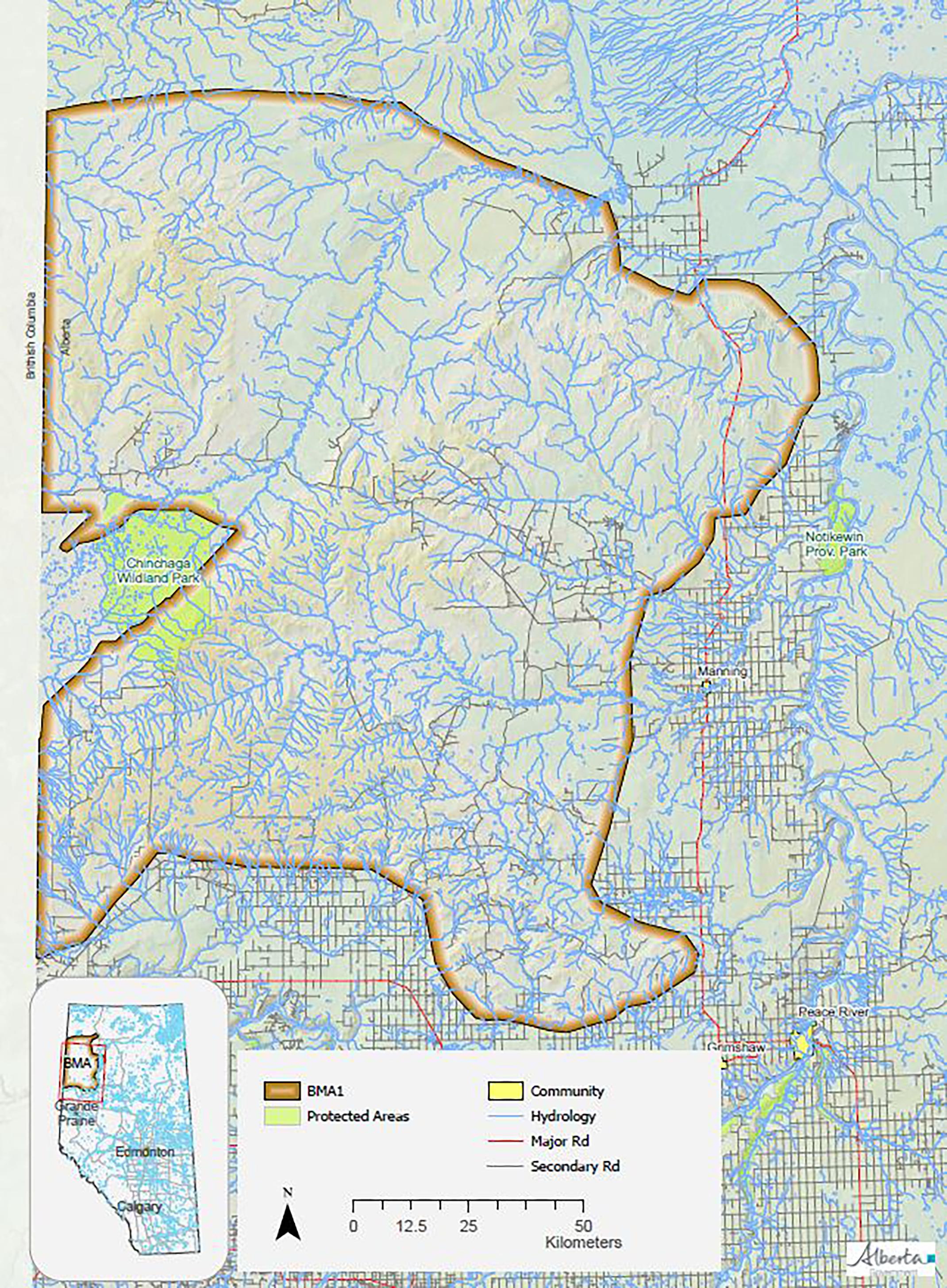
While in recent years a dearth of research and related publications have come out of efforts to understand grizzly bear population, the distribution and human–bear relations in the more southern and central reaches of their range (Morehouse and Boyce 2016; Alberta Environment and Parks 2020; Morehouse et al. 2021; fRI Research 2023), grizzly bears and their relationship to people across the northwest of the province, in Bear Management Area 1 (BMA 1; Fig. 1), are much less understood. Northwest Alberta’s BMA 1 includes a large, multi-use landscape characterized by northern boreal forest with wetland complexes and aspen parkland. BMA 1 covers approximately 41 000 km2 (Alberta Environment and Parks 2020) and extends to the agricultural-forest interface, with an extensive network of roads and linear features as well as smaller urban areas (Hughes et al. 2021). Other human land uses include industrial-scale forest harvest, petroleum developments, varying agricultural production, and recreational pursuits (e.g., hunting, angling, hiking, camping, and off-highway vehicle use; Hughes et al. 2021). Taken together, human presence and corresponding land uses are often included as part of the mortality concerns facing grizzly bears, and are assumed or known to contribute to conflict between people and bears (Hughes et al. 2020, 2021).
Fig. 1.
Recent efforts to better understand the BMA 1 population have estimated a grizzly bear density of 0.70 bears per km2 (Hughes et al. 2021). Unfortunately, due to the low density of grizzly bears in the area, studies estimating populations have been unable to model where grizzly bears are most likely to occur across this vast landscape. As a result, it is still unclear where interactions between humans and grizzly bears are most likely to occur, and thus where there may be increased bear mortality risk, human safety risk, or both. That said, many different people working and residing across BMA 1 often report grizzly bear sightings to local government staff. However, these reports have not been systematically recorded or rigorously collected, rendering this information less useful in applied management decisions. That said, there is acknowledgement that establishing and improving public engagement is a vital component to the long-term conservation of grizzly bears (Gibeau 2012; Proctor et al. 2018; Hughes et al. 2020, 2021). Indeed, the people who live, work, and recreate across BMA 1 play a crucial role in the long-term survival and sustainability of grizzly bears (Hughes et al. 2022b). Specifically, local people can share their first-hand observations of grizzly bears, which can offer insights into bear distribution, behavior, and population (Clark et al. 2014; Hughes and Nielsen 2019; Morehouse et al. 2020). This also presents an opportunity to share information with people who are keen to report their bear observations. This can include educational information on the best available science and research related to grizzly bears, as well as how to stay safe in bear country. Offering opportunities to share and learn can help nurture an ethic of care for grizzly bears, which in turn can aid in the adoption and implementation of grizzly bear recovery efforts (Toomey et al. 2020; Hughes et al. 2022a, 2022b).
We suggest then that to more effectively implement recovery policy and plan for effective management interventions we must have a better spatial understanding of human–bear interactions across BMA 1. Likewise, we need to provide the people who share the landscape with grizzly bears an opportunity to meaningfully contribute to grizzly bear science and management, as well as access relevant and pertinent information and educational experiences. In turn, this would help address the data gaps in grizzly bear recovery, specific to BMA 1, and help deliver on recovery objectives to mitigate human–bear conflicts.
As such, we, the regional government staff tasked with implementing grizzly bear recovery policy objectives, sought to engage local people in BMA 1 in reporting their grizzly bear observations in a systematic way. By soliciting local participation in grizzly monitoring, we aimed to identify how grizzly bears move through human-dominated landscapes to directly improve land use planning decisions and design effective management interventions. We also sought to increase scientific literacy and help foster a stewardship ethic and support for in situ grizzly bear conservation efforts with local people living and working in grizzly bear habitat (Cosquer et al. 2012; Sullivan et al. 2014; Vohland et al. 2019).
Theoretical approach
Community science (also known as citizen science) uses various engagement strategies to solicit voluntary civic participation in research studies, usually through data collection activities (Government of Alberta Ministry of Environment and Parks 2020). This can be an effective strategy to develop the public’s scientific literacy and develop skills related to, in this case, grizzly bear biology, safety, and conflict mitigation, as well as foster a stewardship ethic for grizzly bear conservation and management ( Kollmuss and Agyeman 2002; Clayton and Myers 2015; Phillips et al. 2019; Alberta Environment and Parks 2020; Hughes et al. 2022a). Community engagement in scientific initiatives, including those led by government agencies, can help increase public trust in state-led decision-making by increasing and improving transparency in reporting outcomes, as well as making data collection more efficient, and supporting data analysis procedures (McKinley et al. 2017; Government of Alberta 2020; Hughes et al. 2022b). These positive outcomes can also extend beyond the active participants in community science, to their broader social networks through information sharing and recruitment in science activities (Cosquer et al. 2012).
With this in mind, we thought that formally engaging the people who live, work, and recreate across BMA 1 as community scientists would better enable people to systematically share their grizzly bear sightings, knowledge, and expertise for the purpose of supporting BMA 1 recovery efforts. Additionally, we felt that a community science approach would help expand upon local government staff’s (limited) capability to efficiently collect data across the vast landscape of BMA 1, as well as provide opportunities for sharing and co-learning, and increased communications, between government staff and the public (McKinley et al. 2017; Hughes et al. 2022a; Soroye et al. 2022). In turn, this would help foster better relationships between government and community scientists, as well as provide a more meaningful way to respond to the public’s desire to be involved in grizzly bear science and management.
Enter GrizzTracker
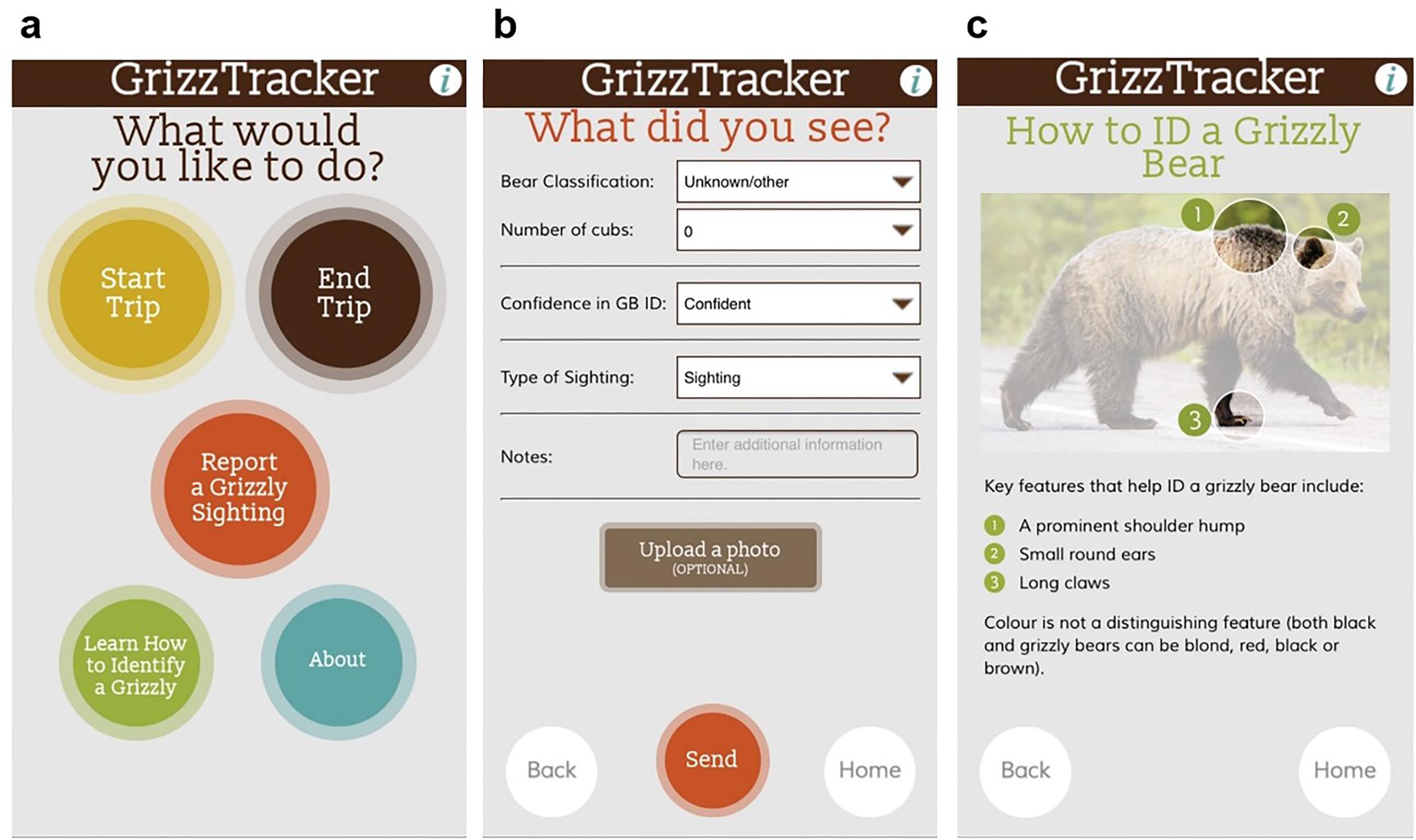
To meaningfully engage community scientists, we created the GrizzTracker (2021) program. This program included a smartphone application (the GrizzTracker app; Fig. 2) to ensure that the data collected by community scientists would be of a rigorous quality and useful to the managing agency in achieving recovery policy outcomes (McKinley et al. 2017; Government of Alberta 2020). This app used a standardized data entry form with drop-down categorical options to help community scientists report their bear observations, along with optional photo upload. This helped to reduce misidentification errors, specifically between black bears and grizzly bears, as well as provide photographic evidence that enabled us to confirm grizzly bears and group size (i.e., sow with cubs). Additionally, the app collected GPS location data at 15 min intervals to reduce sampling biases commonly associated with community science projects (Thornhill et al. 2016; Burgess et al. 2017). We also developed a website to complement the smartphone app, which was used as a broader information sharing and educational approach to increase public awareness and knowledge about the project itself (i.e., blog updates), as well as grizzly bear identification information, bear safety information, grizzly bear science, teacher and classroom resources, and other bear stewardship actions.
Fig. 2.
In addition to examining grizzly bear occurrence data submitted by community scientists, we also sought to understand whether GrizzTracker was an effective community engagement and data collection tool. Thus, we conducted an online evaluative survey of GrizzTracker users to assess their motivations and experiences using the app. Below, we present: (1) the data collected through the GrizzTracker app; and (2) the results of our user survey. Based on these findings, we outline lessons learned to inform future community science efforts that focus on engaging the public in wildlife conservation and management activities.
Methods
Author positionality
RJS is a federal public servant, formerly with the Alberta government, and currently working as the Senior Wildlife Biologist, Wildlife Emergency Response Coordinator. RJS joined this project near the end of the implementation phase. She has a background in biology and environmental science, with extensive knowledge in marine birds. TL is the Director of Conservation Research at Miistakis Institute, a not-for-profit conservation research institute affiliated with Mount Royal University, and assisted in the development of the GrizzTracker program. TL has a background in developing citizen science programs to inform place-based conservation. DD is the Executive Director of the Miistakis Institute and oversees Miistakis’s applied conservation programs. DD has a background in large carnivore connectivity, and works at the interface between academia, policy, and decision-making and community conservation. CH is an Alberta public servant, working as the Senior Landscape Ecologist in the northwest. Her work includes applied conservation research, policy, and landscape and species planning. At the time of this project, CH was the co-chair of the Northwest Grizzly Bear Team, tasked with delivering on Grizzly Bear Recovery Plan objectives for BMA 1. C.H. has a background in conservation biology, education, and social sciences, and uses collaborative and participatory approaches in working with communities to address challenges related to human–wildlife co-existence.
GrizzTracker application
To ensure that public reporting of grizzly bear sightings was standardized, automated, and systematically collected (Sullivan et al. 2014), we created a smartphone application we called the GrizzTracker app. A unique feature of the GrizzTracker app was the ability to spatially and temporally account for volunteer effort while community scientists were driving in BMA 1. Community scientists were instructed to “start a trip” once they started driving and “end trip” when they reached their destination (Fig. 2a). By geo-referencing the users’ locations, we were able to determine observer effort across the study area and in turn account for differences in survey effort across the study area.
We addressed concerns of community scientist’s accuracy in identification of grizzly bears through a variety of methods. Community scientists were instructed to upload a picture of an observed bear, which would later be verified by a government biologist (Fig. 2b). Community scientists were instructed to rate their confidence in their grizzly bear observation by using a three-point confidence rating system. We encouraged community scientists to use the bear identification information we provided via the app and website to differentiate between grizzly and black bears (Fig. 2c). We removed all observations with a non-confident rating from the analysis if a photo was not supplied by the community scientist.
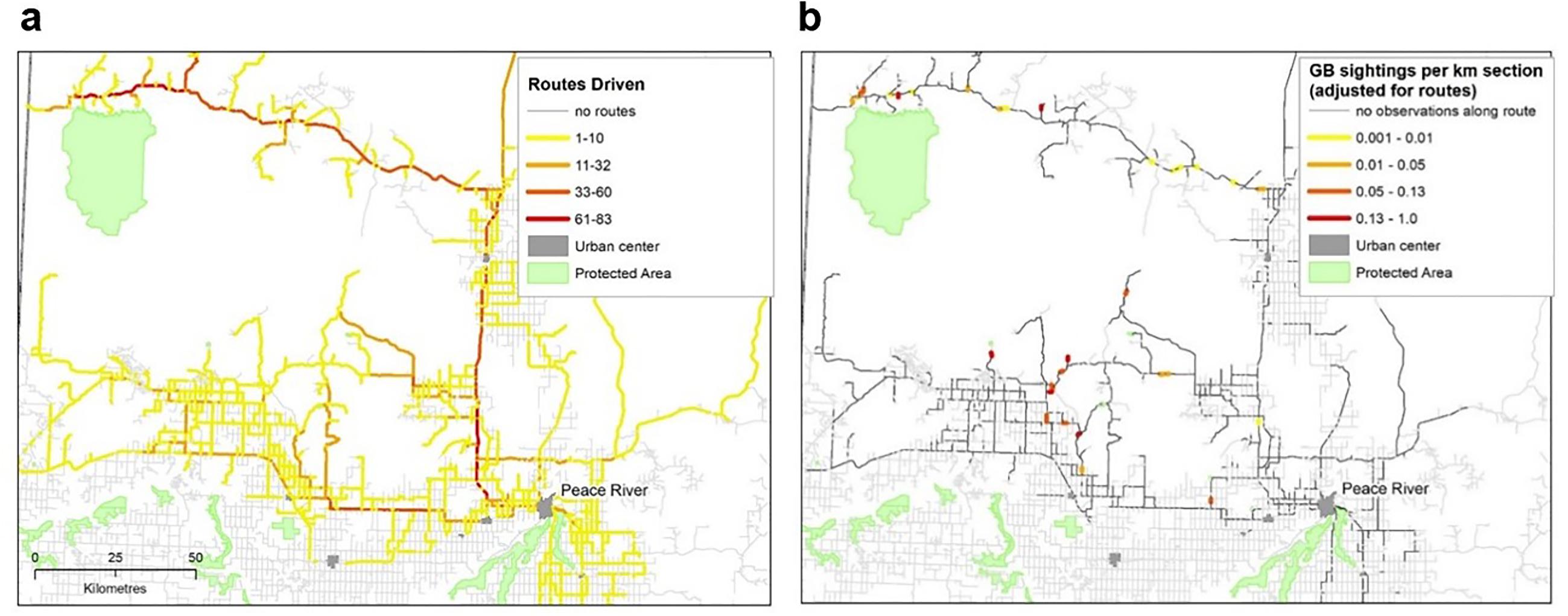
Roads in the study area were divided into 1 km sections and the number of times a section was driven was calculated from the app trip function. Grizzly bear reports were snapped to the roads sections and an index of activity was calculated based on the number of observations and survey effort (number of times the road was driven by the observer).
Given that grizzly bears are a threatened species in Alberta, and many community scientists expressed concern about releasing specific location information associated with reported grizzly bear observations, we included a 2-week time delay and buffer around all detections. This was to alleviate any concerns of this information being used for targeted poaching or illegal hunting and trapping of grizzly bears.
Recruitment of community scientists
Beginning in 2016, we initially recruited community scientists through existing members of the Northwest Grizzly Bear Team (Hughes et al. 2022a). This group of community scientists used the app for a 1-year trial period, and following demonstrated utility and some minor improvements to functionality, the GrizzTracker app was publicly released in 2017 on Google Play and the Apple Store. We then encouraged and recruited broader public use via in-person outreach sessions, social media advertisements, and widespread sharing via the existing community scientists’ social networks.
To better ensure proper use of the app and thus data collection, we held face-to-face training sessions, provided a pdf training manual online and via email, and made ourselves available in person or over the phone to answer questions. Additionally, since related research has shown that it is important for community science programs to clearly articulate what, why, and how data are collected, and to show appreciation for the community scientists’ efforts, we provided frequent (monthly) updates online, on the GrizzTracker website, as well as through in-person meetings with the Northwest Grizzly Bear Team and broader public (Kelling et al. 2015; Bloom and Crowder 2020).
Program evaluation
We evaluated the efficacy of the GrizzTracker program through a short online survey in Google Forms (Supplemental 1), informed by other similar surveys on community science projects including Bumble Bee Watch (MacPhail et al. 2020), eBird Program (Wood et al. 2011), and The Great Pollinator Program (Domroese and Johnson 2017). The recruitment and participation of community scientists in our online survey followed the Government of Alberta’s Freedom of Information and Protection of Privacy Act (2023), which included a statement indicating how data would be kept confidential and used. The survey also included questions on community scientists’ demographics, user experience and motivations for participation, and potential improvements in bear identification skills. We also asked community scientists to provide feedback on how the application could be improved.
We invited all community scientists with registered GrizzTracker application accounts to participate in the survey, via an email. We sent two reminder emails 2 weeks apart, and in total gave community scientists 6 weeks to participate in the survey. We summarized the data using the integrated summary of responses feature in the Google Form.
Grizztracker data
From June 2016 to November 2018, there were 81 grizzly bear sightings, reported by 16 different community scientists. Of these, 84% reported a high level of confidence in their identification of their sighting being a grizzly bear. We removed 17 observations from the analysis where confidence rated by community scientists was low and a photo verification could not be made. Community scientists also contributed 365 independent routes in the study area, with participation from 39 different community scientists and where the average length of a route was 107 km. As expected, the community scientists’ efforts were unevenly distributed within the study area and included community scientists driving the well-used high-grade gravel roads (corresponding to industrial forestry and petroleum activities) entering the Chinchaga forest area north of Peace River, as well as paved and gravel roads in the Hines Creek/Worsley areas (mixed land use including agriculture and industrial activities; Fig. 3a). The highest densities of grizzly bear detections, adjusted for survey effort, were at the end points of roads leading into forested areas near the Chinchaga Wildland Provincial Park (where the park becomes inaccessible/prohibited to on-highway vehicles) and north of Hines Creek (Fig. 3b).
Fig. 3.
Survey outcomes
The survey was emailed to 374 registered users, of which 350 received the survey and 35 individuals responded to the survey, reflecting a 10% response rate. We acknowledge the limitations of this response rate; however, this is not unlike the challenges faced in evaluating other community science programs such as that indicated in MacPhail et al. (2020) with a 5.4% response rate. That said, our survey responses provide important information despite the lack of representation across all GrizzTracker community scientists.
Of those that responded, all but one individual resided in Alberta, with a fairly even split of those residing in rural and urban environments, and only 11% identifying as living in a suburban area. Of the GrizzTracker users, 66% were male and 31% female, with the 3% preferring not to disclose. With regard to age, 37% of respondents were 35–44 years of age and 34% were between 45 and 54 years. The majority of respondents (40%) were employed in industry (i.e., petroleum or forestry sectors), followed by Government of Alberta employees (32%), and non-governmental organizations (14%). We found that 72% of respondents had college, university, or advanced graduate degree, and 23% held a technical or trades diploma. Additionally, 54% of users identified they are members of a wildlife-associated organization, with 65% reporting they use at least one other type of naturalist data collection application.
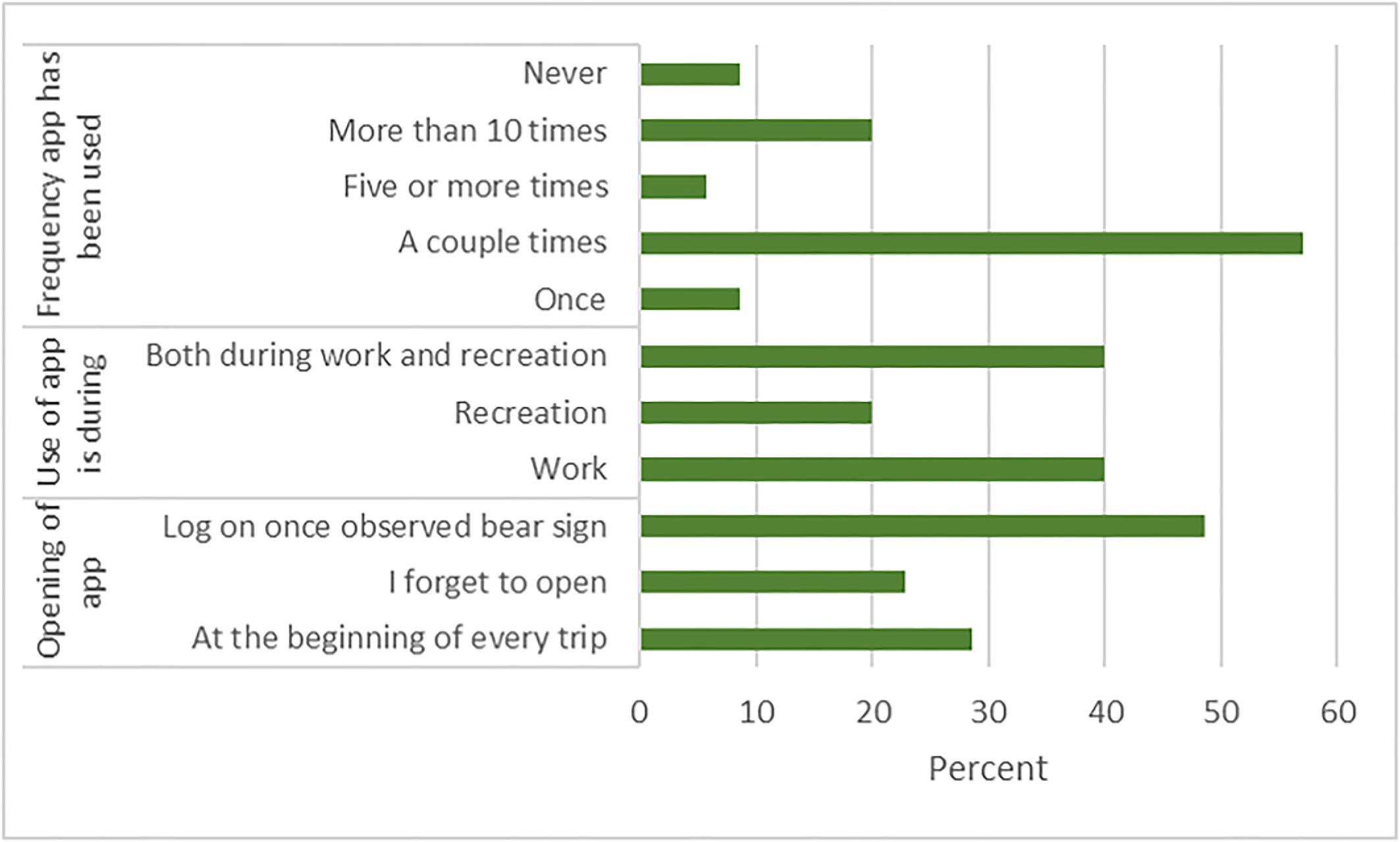
We found that 57% reported to have only used the application a couple times, with 20% indicating that they used the application more than 10 times (Fig. 4). Many of the users reported using GrizzTracker during work (40%), whereas 20% strictly only used the application while recreating; another 40% indicated they used the application during both work and recreation. Only 29% of respondents reported correctly opening the application prior to beginning every trip, whereas 49% of respondents only remembered to log in and use the application after they observed bear sign (Fig. 4).
Fig. 4.
For those that stopped using the GrizzTracker app during the project, reasons included a lack of observing any bears over a period of time (25%) or simply forgetting to turn the app on (25%). Others indicated that the GrizzTracker app drained their cell phone battery so they stopped using it (17%), whereas some reported a lack of receiving feedback on their submissions so they stopped using GrizzTracker (8%). One individual was specifically concerned about the app tracking their personal land use. Despite this, 83% thought the GrizzTracker app was either quite/very easy to use.
In terms of motivations to use GrizzTracker, 83% of respondents indicated they wanted to contribute to grizzly bear science, 63% had a personal interest in grizzly bears, and 31% wanted to contribute to wildlife science more broadly (Fig. 5). Regarding expectations, 83% thought their participation would contribute to grizzly bear science, and 49% wanted to contribute to land management decisions and safety information. Only 11% used GrizzTracker to improve their bear identification skills, with 31% indicating their skills did improve. Relatedly, 68% indicated they were very confident in their grizzly bear identification after participating in the project.
Fig. 5.
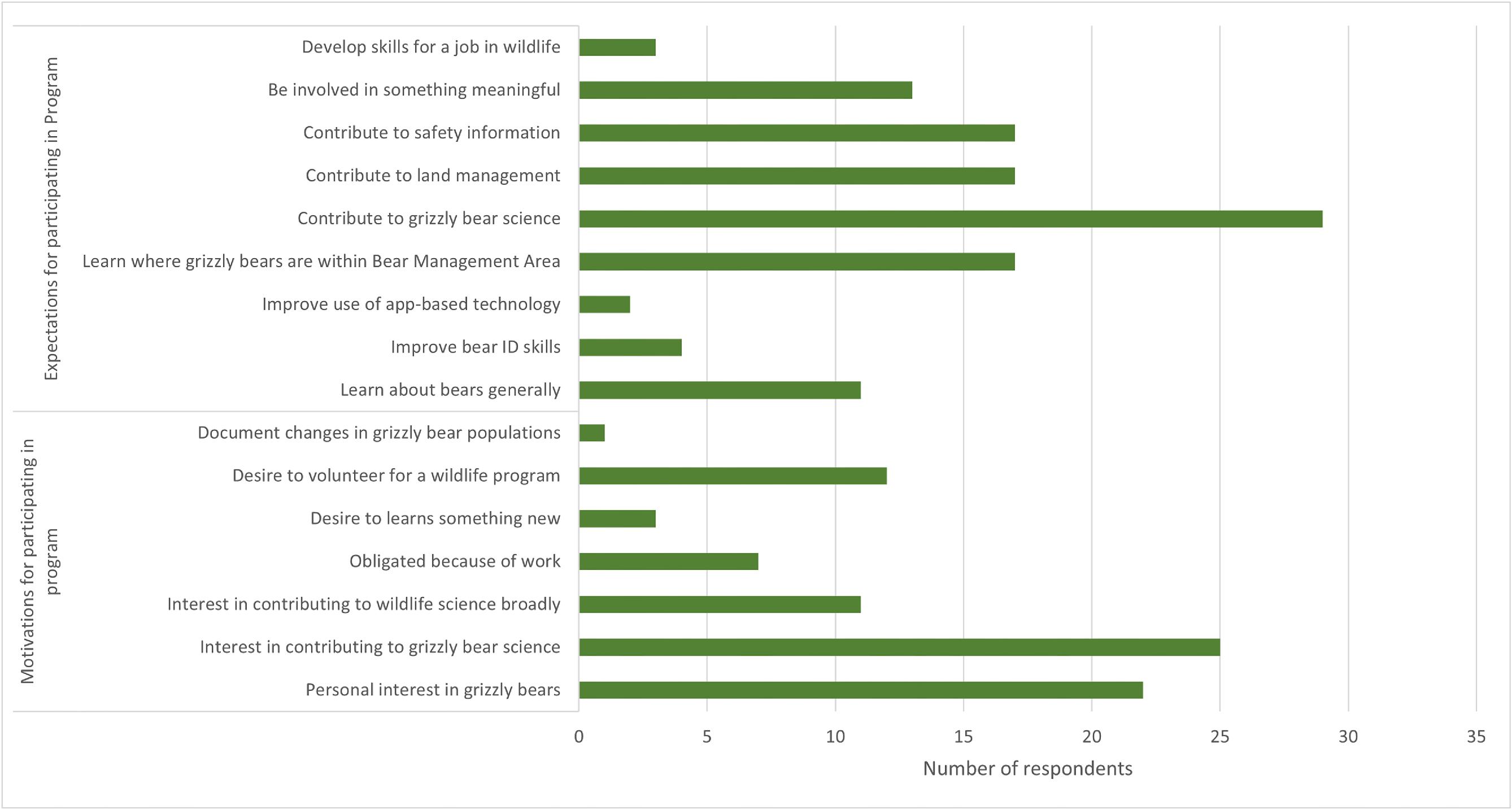
In terms of app improvements, 77% indicated they were satisfied with GrizzTracker, 17% suggested it could be more interactive, 11% suggested the app could enable users to add travel paths after their trip was completed, and 9% indicated they wanted to see where bears were observed by others. Only 6% reported dissatisfaction with not receiving feedback about their submissions. When asked to provide comment on improvements, 9% said they expected feedback on all other reported grizzly bear sightings, with one respondent saying “I originally downloaded it because I thought it would tell me the latest sightings to avoid those areas”. Another respondent indicated they too would “Like to know what the data that is collected is used for, specifically".
Despite this, 46% of respondents felt their knowledge of grizzly bears improved through their engagement in the GrizzTracker project, and that 60% of community scientists recruited others in their social network to join the program. When asked why, respondents cited their desire to improve the utility of the application and to contribute to grizzly bear science.
Discussion
We developed a smartphone-based community science project, and corresponding website, to systematically and automatically collect public-generated data on grizzly bears across Northwest Alberta’s BMA 1. We aimed to generate data that would help inform grizzly bear conservation and management decisions, meaningfully engage community scientists, and evaluate the efficacy of our community science approach, all as part of grizzly bear recovery policy objectives. Overall, we found that GrizzTracker was a useful tool and approach to help improve data collected by members of the public, i.e., community scientists, and increased our confidence in identifying areas with potentially higher densities of grizzly bears and human use co-occurrence. From a bear management perspective, this has helped highlight where we can focus human–bear conflict mitigation efforts (i.e., bear safety education, electric fencing, or other attractant management techniques) as well as considerations for habitat management (i.e., forest harvest or other footprint planning, given connectivity considerations and how to reduce mortality risk; Alberta Environment and Parks 2020; Pers. Comm. L. Fullerton and N. Melnycky 2021; Morehouse et al. 2020).
Through our project, we also demonstrated the necessity and utility of collecting observer effort data, despite some concerns and hesitations from community scientists. Typically, community science projects collect observational data of, for example, individual species detections without real-time accounting for observer effort (e.g., eBird; Sullivan et al. 2014; and Bumble Bee Watch; MacPhail et al. 2020). As a result, species detections can be biased towards areas where people are more likely to purposefully search for their species of interest, which is often closer to urban areas that are easily accessible. Given the potential bias towards areas of higher human use and population, these detections may be less useful for identifying species hotspots, as was our intent with GrizzTracker. Through the collection of real-time observer effort data via GrizzTracker, we were able to determine the location of data collection hotspots by community scientists, and while these were often linked to routinely accessed linear features (i.e., industry roads, trails), we were still able to encourage community scientists to survey more remote locations. Further, we reviewed GrizzTracker data in light of a previous population inventory that sampled remote locations using DNA-based methods (Hughes et al. 2021). Given that we collected real-time observer effort, we were able to remove much of the bias associated with human land use habits and as a result, increased the utility of GrizzTracker-generated data for applied management decisions (Hughes et al. 2022a). Specific to our case, when adjusted for volunteer effort, the highest densities of grizzly bears were detected in the Chinchaga Wildland Park and north of the hamlet of Hines Creek, near the end points of roads entering the forested areas (Fig. 3). These data have provided us with specific locations where we can focus our BearSmart educational outreach efforts and applied conflict mitigation strategies (i.e., electric fencing; Morehouse et al. 2021), to mitigate and reduce human–bear conflicts and thus improve future bear populations sustainability (Hughes et al. 2020).
Another advantage of GrizzTracker was engaging the public in an active and meaningful way, which is an important factor in the success of community science and government-directed conservation programs (Newman et al. 2012; Ceccaroni et al. 2019). When asked why community scientists chose to participate in GrizzTracker, we found it was because our program provided an intriguing opportunity to contribute to grizzly bear science and land management decisions, similar to other research exploring community science (Bonney et al. 2009; Wright et al. 2015; Bloom and Crowder 2020; MacPhail and Colla 2020; Hughes et al. 2022a, 2022b). We also found that community scientists were motivated to recruit their friends, family, or colleagues, further suggesting that GrizzTracker presented a unique and interesting engagement opportunity.
Through this engagement, we were also able to increase scientific literacy of community scientists in data collection and analysis methods, the use of data in decision-making, policy, and management, and grizzly bear biology and ecology. By increasing people’s understanding of how grizzly bears use the landscape, we hoped that people would be inclined to adopt conflict mitigation practices (e.g., a farmer involved as a community scientist may invest in electric fencing or an oilfield employee may implement safety protocols for working in bear country). Further, we suggest that the educational information available on the GrizzTracker website, combined with public outreach sessions, email updates, and numerous informal conversations, contributed to cultivating meaningful engagement opportunities while enhancing awareness, knowledge, and understanding across the participating community scientists. However, we do note a critical gap in our engagement efforts, including a lack of Indigenous community scientists as well as agricultural landowners, as noted in Hughes et al. (2022a). We therefore suggest that others interested in pursuing community science projects would be well served to carefully consider the value of adopting multiple forms of engagement and educational strategies, seeking out formal and informal collaborations with various individuals and groups, and carefully consider and plan for an inclusive program to help achieve a project’s intended outcomes (Hughes et al. 2022a, 2022b).
In terms of improvements, we found that some users reported being frustrated with GrizzTracker because they expected to be provided with verification on their grizzly bear observations, and more specifically, real-time mapped locations of bears. Some users cited their safety concerns of working in bear country, where real-time reported bear locations would help address this. We did not provide real-time mapped locations of grizzly bears via the app for two reasons: (a) to better protect grizzly bears, which was particularly important given the species-at-risk status and potential for conflict or deviant behavior (i.e., poaching and/or illegal trapping) if bear locations were immediately known (Hughes and Nielsen 2019); and (b) financial and time limitations of creating this functionality in the app. Instead we provided a map of buffered locations of grizzly bear detections, with 2-week delay, on the GrizzTracker website and attempted to communicate any bear activity in the immediate vicinity of any employees to the site supervisor of an area, upon an observation being reported. While we maintain the need to protect the specific locations of reported grizzly bear observations over concern for mortality risks, we do think this issue represents the need for very clear communications from project managers on what community scientists can expect from their participation and why certain elements of a project can or cannot be shared. We also think this issue helps to highlight how unintended tensions between engagement and science goals can arise, and thus must be given fulsome consideration through a reflective process during project planning and throughout implementation (Lee et al. 2021).
Lastly, we note that not all community scientists are as eager to collect data and that some may be more interested in learning (Bloom and Crowder 2020). We found that our website and public outreach sessions were advantageous to build broader public interest, not only GrizzTracker but also in grizzly bear recovery overall, and represent an opportunity that other community science projects consider using in their project design.
Conclusion
Community science is a burgeoning field that is increasingly used by government and non-government organizations to help inform wildlife conservation and management (e.g., North American Breeding Bird Surveys; United States Geological Survey 2018; and Amphibian Monitoring; Lee et al. 2021). Indeed, the successful engagement of community scientists requires careful considerations for human, social, technological, and financial capital investment in the design, development, and implementation of data collection protocols and analysis, as well as the importance of clearly communicated outcomes and opportunities for educational outreach. In our case, the Northwest Grizzly Bear Team invested considerable time and financial resources to design, develop, and implement the program (Hughes et al. 2021, 2022a), and while the shared goals and costs between partners can improve program sustainability, GrizzTracker still suffered from various issues (Shirk et al. 2012). This included the loss of funding for a staff position responsive for community engagement, which in turn decreased the frequency of public educational outreach and resulted in related user complaints. While we attempted to strategically consider program resiliency when building GrizzTracker, sustaining long-term investment is difficult for governments and even industrial partners, given varying political and other priorities, staffing changes, financial uncertainty, or fluctuations in volunteer interest and commitment (Hughes et al. 2022a). Regardless, long-term investment in programs like GrizzTracker is required including dedicated staff, funding, and technological supports, if robust data collection and community science capacity-building is desired (Hughes et al. 2022a). We do note that other platforms, such as iNaturalist, may be useful, in part because it is a cost-effective platform independent of (in our case) government funding cycles (however, this may also be a risk if/when independent funding ceases); uses automatic identification of various species; removes or reduces upfront costs for project development and maintenance; has the ability to collect large quantities of data and increased utility of these datasets for other projects; data are accessible for public consumption; and may hold greater public trust because the platform is already known and accepted (Wittmann et al. 2019). Indeed, iNaturalist is used by the Government of Alberta, currently for encouraging public participation in biological inventories across different protected areas.
However, iNaturalist still may suffer from implementation and sustainability issues including a lack of dedicated staffing to champion programs and be a point of contact for public users; poor-quality photo submissions; user selection limitations; and waning long-term and consistent use by community scientists (i.e., as observed in the Government of Alberta’s use for protected area bio-inventories). We suggest that developing a novel project such as ours can help deliver on the specific desires and needs that community scientists want to see in a project and can create safeguards on data to help protect grizzly bears while still sharing timely information. We do note, however, that the cost of developing GrizzTracker, including contracting those with expertise in developing this technology, staff to champion the program, outreach costs, and longer term maintenance costs, is a consideration that needs to be carefully considered for any program, regardless if novel like ours or using an existing platform.
Based on our project learnings, we also suggest that it is important to consider whether the community scientists engaged in the project have the knowledge, understanding, and skills to collect data in a rigorous way, which includes give consideration for how to address concerns around quality assurance and quality control (Riesch and Potter 2013; Wittmann et al. 2019; Soroye et al. 2022). As suggested elsewhere, we too have found that these concerns can be alleviated through proper design, training, and testing for biases and outliers during data analysis (McKinley et al. 2017; Hughes et al. 2022a). There have been numerous studies comparing the ability of community scientists to collect accurate data to that of a professional scientist, and in many cases these projects have been found to collect high-quality data when properly implemented (Gollan et al. 2012; Jackson et al. 2015).
While there is continued trepidation by traditionally trained scientists to develop or engage in community science programs, we think that GrizzTracker offers a success story in community science (Hughes et al. 2022a). In addition to standardizing and automating data collection, we had thorough planning, testing, engagement, and training for our community science project. This helped to ensure clear outcomes and consistent and proper use of the GrizzTracker app itself, as well as encouraged widespread recruitment by other community scientists in our project. As a result, we have been provided with community-generated data that help us better understand grizzly bear use of a human-dominated landscape, showing where people may interact with a higher density of grizzly bears in BMA 1, and relatedly, take precautions to avoid potential conflict areas and plan for mitigations. GrizzTracker also has provided an educational opportunity for community scientists and the broader public, via public outreach sessions, and blog and email updates, which in turn has helped develop more transparent communication channels between government and the public, as well as increase scientific literacy and foster trust.
Based on our learnings, we think there may be future opportunity to expand GrizzTracker across grizzly bear range in Canada and the United States, or perhaps consider the utility of the app as a platform for all bear species, in a global context. However, the community must truly decide whether this is the type of project they want, as it is the community scientists who will determine whether these types of projects are successful.
Acknowledgements
We appreciate all the community scientists who participated in this program. We are thankful for the contributions and collaboration with forest tenure holders including Mercer Peace River Pulp Ltd., Canadian Forest Products, Tolko Industries, Manning Diversified Forest Products (a div. of West Fraser), and Boucher Bros. Lumber Ltd.; energy companies including Canadian Natural Resources Ltd., Husky Energy, and Shell; electrical company ATCO; KayeDon Wilcox, Natalka Melnycky, Lyle Fullerton, Bonnie Hood, and Paul Frame with the Government of Alberta; Gordon Stenhouse from fRI; Alberta Conservation Association; Alberta Agriculture and Forestry; Alberta Energy Regulator; and Luke Vander Vennen, now with the Government of British Colombia. We are also grateful for Ken Sanderson from Miistakis for building the smartphone application and assisting with data management.
References
Alberta Environment and Parks. 2020. Alberta grizzly bear (Ursus arctos) recovery plan. Alberta Species at Risk Recovery Plan No. 38. Edmonton, AB.
Alberta Sustainable Resource Development. 2008 Alberta Grizzly Bear Recovery Plan 2008-2013. Edmonton: Alberta Sustainable Resource Development.
Bloom E.H., Crowder D.W. 2020. Promoting data collection in pollinator citizen science projects. Citizen Science: Theory and Practice, 5(1): 1–12.
Bonney R., Cooper C.B., Dichinson J., Kelling S., Phillips T., Rosenberg K.V., Shirk J. 2009. Citizen science: a developing tool for expanding science knowledge and scientific literacy. Bioscience, 59(11): 977–984.
Burgess H.K., DeBey L.B., Froehlich H.E., Schmidt N., Theobald E.J., Ettinger A.K., et al. 2017. The science of citizen science: exploring barriers to use as a primary research tool. Biological Conservation, 208: 113–120.
Ceccaroni L., Bibby J., Roger E., Flemons P., Michael K., Fagan L., Oliver J.L. 2019. Opportunities and risks for citizen science in the age of artificial intelligence. Citizen Science: Theory and Practice, 4(1): 1–29.
Chamberlain E.C., Rutherford M.B., Gibeau M.L. 2012. Human perspectives and conservation of grizzly bears in Banff National Park, Canada. Conservation Biology, 26(3): 420–431.
Clark S.G., Rutherford M.B., Mattson D.J. 2014. Large carnivores, people and governance in large carnivore conservation: integrating science and policy in the North American west (1–28). The University of Chicago Press, Chicago, IL.
Clayton S.D., Myers G. 2015. Conservation psychology: understanding and promoting human care for nature. 2nd ed. Wiley-Blackwell.
Cosquer A., Raymond R., Prevot-Julliard A.C. 2012. Observations of every day biodiversity: a new perspective for conservation. Ecology and Society, 17(4).
Domroese M.M., Johnson E.A. 2017. Why watch bees? Motivations of citizen science volunteers in the Great Pollinator Project. Biological Conservation, 208: 40–47.
fRI Research. 2023. Grizzly bear program. Available from https://friresearch.ca/program/grizzly-bear-program [accessed 12 April 2023].
Gibeau M.L. 2012. Of bears, chess and checkers: moving away from pure science to solve problems. The Wildlife Professional, Spring 2012.
Gollan J., De Bruyn L.L., Reid N., Wilkie L. 2012. Can volunteers collect data that are comparable to professional scientists? A study of variables used in monitoring the outcomes of ecosystem rehabilitation. Environmental Management, 50(5): 969–978.
Government of Alberta, Ministry of Environment and Parks. 2020. Citizen science principles of good practice. ISBN 978-1-4601-4651. Available from https://open.alberta.ca/publications/9781460146514 [accessed 4 May 2021].
GrizzTracker. 2021. www.GrizzTracker.ca [accessed 5 May 2021].
Hughes C., Nielsen S.E. 2019. Bear are only the lightning rod: ongoing acrimony in Alberta's grizzly bear recovery. Society and Natural Resources, 32(1): 34–52.
Hughes C., Elmeligi S., Morehouse A. 2022b. Conservation through connection: approaches to engaging communities in applied grizzly bear research. Frontiers in Conservation Science, 3: 913668.
Hughes C., Steenweg R.J., Vander Vennen L.M., Melnycky N.A., Fullerton L., Witiw J.T., Morehouse A. 2021. Working together for grizzly bears: a collaborative approach to estimate population abundance in Northwest Alberta. Frontiers in Conservation Science, 2: 719044.
Hughes C., Tremblett K., Kummer J., Lee T.S., Duke D. 2022a. How can we do citizen science better? A case study evaluating grizzly bear citizen science using principles of good practice in Alberta, Canada. Animals, 12(9): 1068.
Hughes C., Yarmey N., Moorehouse A., Nielson S. 2020. Problem perspectives and grizzly bears: a case study of Alberta's grizzly bear recovery policy. Frontiers in Ecology and Evolution, 8: 38.
Jackson M.M., Gergel S.E., Martin K. 2015. Citizen science and field survey observations provide comparable results for mapping Vancouver Island White-tailed Ptarmigan (Lagopus Leucura Saxatilis) distributions. Biological Conservation, 181(1): 162–172.
Kelling S., Fink D., La Sorte F.A., Johnston A., Bruns N.E., Hochachka W.M. 2015. Taking a big data approach to data quality in a citizen science project. Ambio, 44(4): 601–611.
Kollmuss A., Agyeman J. 2002. Mind the gap: why do people behave environmentally and what are the barriers to pro-environmental behaviour. Environmental Education Research, 8(3): 239–260.
Lee T.S., Kahal N., Kinas H.L., Randall L.A., Baker T.M., Carney V.A., et al. 2021. Advancing amphibian conservation through citizen science in urban municipalities. Diversity, 13(5): 211.
MacPhail V.J., Colla S.R. 2020. Power of the people: a review of citizen science programs for conservation. Biological Conservation, 249: 108739.
MacPhail V.J., Gibson S.D., Colla S.R. 2020. Community science participants gain environmental awareness and contribute high quality data but improvements are needed: insights from bumble bee watch. PeerJ, 8: e9141.
McKinley D.C., Miller-Rushing A.J., Ballard H.L., Bonney R., Brown H., Cook-Patton S.C., et al. 2017. Citizen science can improve conservation science, natural resources management and environmental protection. Biological Conservation, 208: 15–28.
Morehouse A.T., Boyce M. 2016. Grizzly bears without borders: spatially explicit capture–recapture in Southwestern Alberta. The Journal of Wildlife Management, 80(7).
Morehouse A.T., Hughes C., Manners N., Bectell J., Bruder T. 2020. Carnivores and communities: a case study of human–carnivore conflict mitigation in Southwestern Alberta. Frontiers in Ecology and Evolution, 8: 2.
Morehouse A.T., Hughes C., Manners N., Bectell J., Tigner J. 2021. Dealing with deadstock: a case study of carnivore conflict mitigation from southwestern Alberta. Frontiers in Conservation Science, 2: 786013.
Newman G., Wiggins A., Crall A., Graham E., Newman S., Crowston K. 2012. The future of citizen science: emerging technologies and shifting paradigms. Frontiers in Ecology and the Environment, 10(6): 298–304.
Nielsen S. E., Cranston J., Stenhouse G. B. 2009. Identification of priority areas for grizzly bear conservation and recovery in Alberta, Canada. Journal of Conservation Planning, 5(4): 38–60.
Phillips T.B., Ballard H.L., Lewenstein B.V., Bonney R. 2019. Engagement in science through citizen science: moving beyond data collection. Science Education, 103(3): 665–690.
Proctor M.F., Kasworm W.F., Annis K.N., MacHutchon A.G., Teisberg J.E., Radandt T.G., Servheen C. 2018. Conservation of threatened Canada-USA trans-border grizzly bears linked to comprehensive conflict reduction. Human–Wildlife Interactions, 12(3): 348–372.
Riesch H., Potter C. 2013. Citizen science as seen by scientists: methodological, epistemological and ethical dimensions. Public Understanding of Science, 23(1): 107–120.
Shirk J.L., Ballard H.L., Wilderman C.C., Phillips T., Wiggins A., Jordan R., et al. 2012. Public participation in scientific research: a framework for deliberate design. Ecology and Society, 17(2): 29.
Soroye P., Edwards B.P.M., Buxton R.T., Ethier J.P., Frempong-Manso A., Keefe H.E., et al. 2022. The risks and rewards of community science for threatened species monitoring. Conservation Science and Practice, E12788.
Sullivan B.L., Aycrigg J.L., Barry J.H., Bonney R.E., Bruns N., Cooper C.B., et al. 2014. The eBird enterprise: an integrated approach to development and application of citizen science. Biological Conservation, 169(1): 31–40.
Thornhill I., Loiselle S., Lind K., Ophof D. 2016. The citizen science opportunity for researchers and agencies. Bioscience, 66(9): 720–721.
Toomey A.H., Strehlau-Howay L., Manzolillo B., Thomas C. 2020. The place-making potential of citizen science: creating social-ecological connections in an urbanized world. Landscape and Urban Planning, 200: 103824.
United States Geological Survey. 2018. Patuxtent Wildlife Research Center. Available from https://www.pwrc.usgs.gov/bbs/about/ [accessed 17 August 2021].
Vohland K., Weibpflug M., Pettibone L. 2019. Citizen science and neoliberal transformation of science—an ambivalent relationship. Citizen Science: Theory and Practice, 4(1): 25.
Wittmann J., Girman D., Crocker D. 2019. Using iNaturalist in a coverboard protocol to measure data quality: suggestions for project design. Citizen Science: Theory and Practice, 4(1): 21.
Wood C., Sullivan B., Iliff M., Fink D., Kelling S. 2011. eBird: engaging birders in science and conservation. Plos Biology, 9(12): e1001220.
Wright D.R., Forister M.L., Keene M., Knight A.T. 2015. Understanding the motivations and satisfactions of volunteers to improve the effectiveness of citizen science programs. Society and Natural Resources, 28(9): 1013–1029.
Supplementary material
Supplementary Material 1 (PDF / 183 KB).
- Download
- 183.52 KB
Information & Authors
Information
Published In
FACETS
Volume 9 • January 2024
Pages: 1 - 11
Editor: David Lesbarrères
History
Received: 3 February 2023
Accepted: 26 June 2023
Version of record online: 8 February 2024
Copyright
© 2024 The Author(s). This work is licensed under a Creative Commons Attribution 4.0 International License (CC BY 4.0), which permits unrestricted use, distribution, and reproduction in any medium, provided the original author(s) and source are credited.
Data Availability Statement
Data may be available upon request.
Key Words
Sections
Subjects
Plain Language Summary
Community scientists support grizzly bear conservation: an Alberta case study
Authors
Author Contributions
Conceptualization: TSL, CH
Data curation: RJS, TSL, CH
Formal analysis: RJS
Funding acquisition: CH
Investigation: TSL, CH
Methodology: TSL, CH
Project administration: TSL, CH
Resources: CH
Software: TSL, CH
Supervision: CH
Validation: RJS, TSL
Visualization: RJS, TSL
Writing – original draft: RJS, TSL, DD, CH
Writing – review & editing: RJS, TSL, DD, CH
Competing Interests
There are no competing interests. Miistakis Institute, place of employment for two co-authors TL and DD, was legally contracted for the development of the GrizzTracker smartphone application and website design. CH and RJS were employed with the Government of Alberta and tasked with this work at the time of the project.
Funding Information
Forest Resources Improvement Association of Alberta: FRIAA-FFI-16-007
Mercer Peace River Pulp Ltd.
This work was supported by a Forest Resources Improvement Association of Alberta grant (FRIAA-FFI-16-007), Alberta Conservation Association, annual funding support from Mercer Peace River Pulp Ltd., and Alberta government contributions.
Metrics & Citations
Metrics
Other Metrics
Citations
Cite As
Rolanda J. Steenweg, Tracy S. Lee, Danah Duke, and Courtney Hughes. 2024. Using community science to advance grizzly bear conservation. FACETS.
9(): 1-11. https://doi.org/10.1139/facets-2023-0020
Export Citations
If you have the appropriate software installed, you can download article citation data to the citation manager of your choice. Simply select your manager software from the list below and click Download.
There are no citations for this item