Data and knowledge needs for improving science and policy for peatlands in Canada in a changing world: insights from Global Peatlands Initiative Workshop, June 2023
Abstract
Knowledge and data on the current function, future threats, and benefits of peatlands in Canada are required to support evidence-based decision-making to ensure they continue to provide critical ecosystem services. This is particularly relevant for Canada, given the large expanse of relatively intact peatland area. There is a need, not only to standardize protocols, but also to prioritize types of information and knowledge that can best meet conservation and management goals. This was the challenge posed to the participants of the Global Peatlands Initiative workshop in June 2023 in Quebec City, Quebec, Canada. Participants were composed of researchers using primarily Western science approaches that use peatland data for carbon accounting, policy or sustainable land use, reclamation/restoration, conservation, wildlife, and water resources applications. For seven peatland data categories (hydrometeorological and environmental sensing; peat coring and depth; greenhouse gas monitoring; biodiversity; vegetation, woody debris, and litter; Traditional Knowledge; water quality), three priority measurements were identified and recommendations for their collection were discussed. The key recommendations from the workshop were to (1) create standardized, yet flexible protocols; (2) coordinate field data collection where possible; (3) weave more Traditional Knowledge into understanding of peatlands; (4) create an atlas of existing peatland information; (5) scope opportunities to create a network of peatland “super sites”.
1. Introduction
Peatlands are wetland ecosystems that have accumulated partially decomposed organic material, i.e., peat, to a thickness of at least 40 cm in Canada (NWWG 1997). There is growing recognition of the important role that peatlands play in ecosystem service provision, including contributions to climate regulation, biodiversity support, water resource management, water quality protection, and nutrient cycling (Frolking and Roulet 2007; Minayeva and Sirin 2012; Leifeld and Menichetti 2018; Xu et al. 2018; Taillardat et al. 2020). Peatland protection and restoration have been cited as important actions to meet commitments under both climate action and biodiversity protection strategies (Joosten 2015; IUCN 2021; UNEP 2022). Despite this role, peatlands are facing many threats, such as drainage for agriculture, forestry and peat extraction, excavation during mining activities, and climate change-induced disturbances, such as permafrost thaw, and greater frequency and severity of droughts and wildfires (e.g., Harris et al. 2022). These threats are particularly apparent at high latitudes where climate warming is proceeding at a rate much higher than the global average (IPCC 2021) and where resource extraction is also expanding (e.g., Wang et al. 2020). Therefore, decisions about where to prioritize specific peatland management actions will need to be made in an era of change, in terms of changes not only to the physical environment but also changes in values and policy frameworks (e.g., Brown 2020; Moxey et al. 2021).
Knowledge and data on current peatland ecosystem functions and services, future threats, and opportunities for peatland conservation are required to support evidence-based decision-making on peatland management and stewardship (Reed et al. 2022). This is particularly relevant in a Canadian context given that Canada is home to one-quarter of the world's peatlands, 98% of which remain in a relatively intact state (Rochefort et al. 2022), but also where less than 10% have formal protection (Harris et al. 2022). Given Canada's vast peatland area, appropriate management will be important for the country to meet commitments under multinational environmental agreements and national climate action and biodiversity goals. For example, avoided peatland conversion (i.e., keeping intact peatlands undisturbed) was estimated to result in greenhouse gas (GHG) emission reductions of 10.1 Mt CO2-e in 2030, contributing 12% of calculated natural climate solutions for Canada (Drever et al. 2021). Further, Canada has committed to conserving 30% of its land and water by 2030 (Government of Canada 2023). This will require information to inform decisions to best support benefits to water resources, biodiversity, and climate (Mitchell et al. 2021). Canada has also committed to support Indigenous-led conservation, e.g., Indigenous Protected and Conserved Areas, and to the goal of conservation in Canada as a path towards reconciliation (TRCC 2015a, 2015b; Indigenous Circle of Elders 2018; Moola and Roth 2019).
Although Canada has a rich history of peatland research based on Western science (Price et al. 2023), and a much longer memory of peatland conditions as Traditional Knowledge (Cimellaro 2022), this information has been collected for specific purposes and often only at specific locations. As has been widely acknowledged, a lack of standardization in the collection of information and inconsistent reporting of results creates challenges for evidence-based decision-making (Taylor et al. 2019; Bansal et al. 2023). Comparing results among studies using disparate methods can result in high levels of uncertainty that limit the utility of the outcomes for informing policy and practice. For this reason, there are many examples of standardized data collection protocols that have been developed (e.g., Canadian Council of Ministers of Environment 2011; Pastorello et al. 2020; EPA 2023; Magnan et al. 2024). As well, data that can be collected may be limited by many constraints, including cost, expertise, and site access (e.g., Nwaishi et al. 2015). For peatlands in Canada, their vast area, often remote location, and restrictive frozen conditions for a substantial part of the year all complicate field data collection. There is a need not only to standardize data and knowledge collection protocols but also to prioritize types of information and knowledge that can best meet management and policy goals while considering logistical constraints related to the methodology required.
As a tool to identify key metrics of peatland function, a workshop was organized in June 2023 in Quebec City, Quebec, Canada by the Global Peatlands Initiative (https://www.globalpeatlands.org/), the Peatland Ecosystem Research Group (PERGwww.perg-gret.ulaval.ca), and the Can-Peat project (https://uwaterloo.ca/can-peat/). Discussions were focused on the following themes:
1.
Applications and end uses/users of peatland data and knowledge.
2.
Types of data/knowledge that are most needed for these applications/end users.
3.
Collection methods for priority data.
4.
Coordinating peatland data collection and management.
Through these discussions, the end goal was to forge a path towards mobilizing new multidisciplinary research and collaboration as well as compiling and consolidating existing knowledge, data, and experience of Canada's peatlands.
2. Methods
To identify priority peatland data and information that would be useful for a range of management and policy goals, we compiled information from peatland experts across a range of disciplines and sectors in a workshop setting. A similar approach, sometimes referred to as expert elicitation, has been used in several environmental conservation and management prioritization exercises, including recent examples that focus on peatlands in other regions of the world (Padfield et al. 2015; Reed et al. 2022; Rowland et al. 2023). This work occurred on the second day of the 2-day workshop that consisted of a plenary session on applications and end uses of peatland data and knowledge for decision-making, followed by breakout group discussions on collecting peatland data and knowledge. The day concluded with a group conversation to summarize and synthesize themes arising from the presentations and breakout groups.
2.1. Overview of the participants
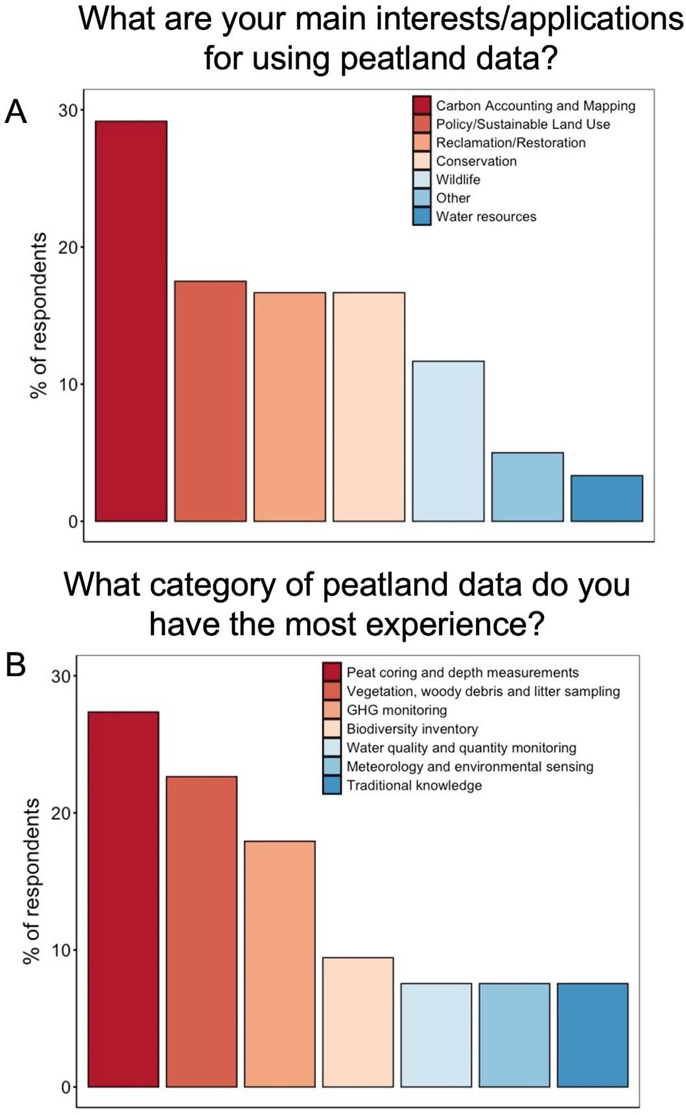
Participants in the workshop reflected different interests and expertise in peatlands with the goal to gain insight from a range of potential users of peatland data and information. Most participants were from Canada, but some were from other countries (see Supplementary material Table S1). The participants generally were composed of researchers using Western science approaches, with interest predominantly in carbon accounting, policy or sustainable land use, reclamation/restoration, or conservation (Fig. 1A). The expertise of the participants was primarily in the areas of peat coring and depth, vegetation, wood debris and litter, and GHG monitoring (Fig. 1B).
Fig. 1.
2.2. Plenary session on applications and end uses/users of peatland data and knowledge for decision-making
The first part of the workshop had a panel of five speakers representing four different peatland themes related to academic science research, conservation, reclamation/restoration, and national synthesis and reporting. Each presenter discussed data needs, challenges, and opportunities specific to those themes. Michelle Garneau (UQAM) presented on the need and value of a comprehensive peatland database. Two speakers presented peatland conservation perspectives. Lorna Harris (Wildlife Conservation Society (WCS) Canada) presented on peatland policy initiatives and Matt Munson (Dene Tha First Nation) discussed community-led monitoring initiatives. Bin Xu (Northern Alberta Institute of Technology (NAIT) Centre for Boreal Research) presented a reclamation/restoration perspective describing his work in the Alberta Oil Sands region on site-scale peatland restoration. A national synthesis and GHG reporting perspective presentation was given by Kelly Bona (Environment and Climate Change Canada (ECCC)).
Across all presentations, the importance of peatlands in Canada was highlighted alongside calls for collaborative collection and sharing of data and knowledge. Speakers stressed the need for data to support a range of actions related to peatland management, including land use planning and peatland protection strategies, national reporting to multilateral environmental agreements (e.g., anthropogenic GHG emission reporting to the United Nations Framework Convention on Climate Change), restoration planning and implementation, and policy guidance. In addition to access to peatland information, there is an urgent need to harmonize data, so that it can be used beyond specific project goals. Many tools are emerging to facilitate this harmonization, including community-led monitoring using apps for field data collection, national models such as the Canadian Model for Peatlands (CaMP; Bona et al. 2020, 2024), provincial databases on peat physical and chemical properties, and technical guides for peat sample collection (Magnan et al. 2023, 2024) and restoration (e.g., NAIT technical resources (ait.ca/borealresearch); Quinty et al. 2020).
2.3. Breakout group discussion on collecting peatland data and knowledge
The second part of the workshop was a group discussion on different types of peatland data collection, organized around different categories of peatland information. The categories included: (1) hydrometeorological and environmental sensing; (2) peat coring and depth; (3) GHG monitoring; (4) biodiversity; (5) vegetation, woody debris, and litter; (6) Traditional Knowledge; and (7) water quality.
The goals of the breakout session were to:
1.
Identify the types of peatland data/information that are collected within these different categories.
2.
For each type of data/information, discuss the best ways to measure them.
3.
Prioritize the types of data/information to be collected.
To do this, participants were asked to choose the category of peatland data collection that they felt they had the most expertise in. Each category was assigned a different table with a printout, pre-populated with data/information specific to that category. Each table had two facilitators to record the discussion. The participants were asked to add any data/information missing from the list for the category and then, for each of those types of data/information, discuss the best ways to measure/collect them. The focus was primarily on methods of measurement and data collection in the field. Specifically, participants were asked to consider questions, such as:
•
Where should measurements/samples be taken?
•
How should measurements/samples be taken and how many?
•
If samples are taken, how should samples be stored?
•
How should samples be processed (if needed before analysis)?
•
Recommendations, tips and tricks, advice about equipment, references, or existing written protocol.
Following information gathering, the participants took part in a prioritization exercise. For the application that they were most familiar with (i.e., carbon accounting and mapping, wildlife, water resources, reclamation/restoration, conservation, and policy or sustainable land use), they were asked what they felt the most important measurements were to make. Participants had the opportunity to visit all the tables/categories and place a vote (i.e., sticker dot with colour corresponding to their application) on what they felt were the most important data types. Each participant had 10 votes (i.e., stickers) and could decide on which data type to place them to reflect their values for prioritization (i.e., one sticker each on 10 different types of data (e.g., water table, peat depth, methane emissions, etc.), all 10 stickers on one key data type, or an intermediate approach).
Given there was an imbalance in the areas of expertise among participants (see overview of participants above), we summarized the types of data within each category based on ranking (most votes to least) and recorded which applications used the data, not the total number of votes per application. Although this analysis is imperfect and incomplete, we feel that many insights were gained from the exercise.
3. Results
3.1. Breakout group discussion
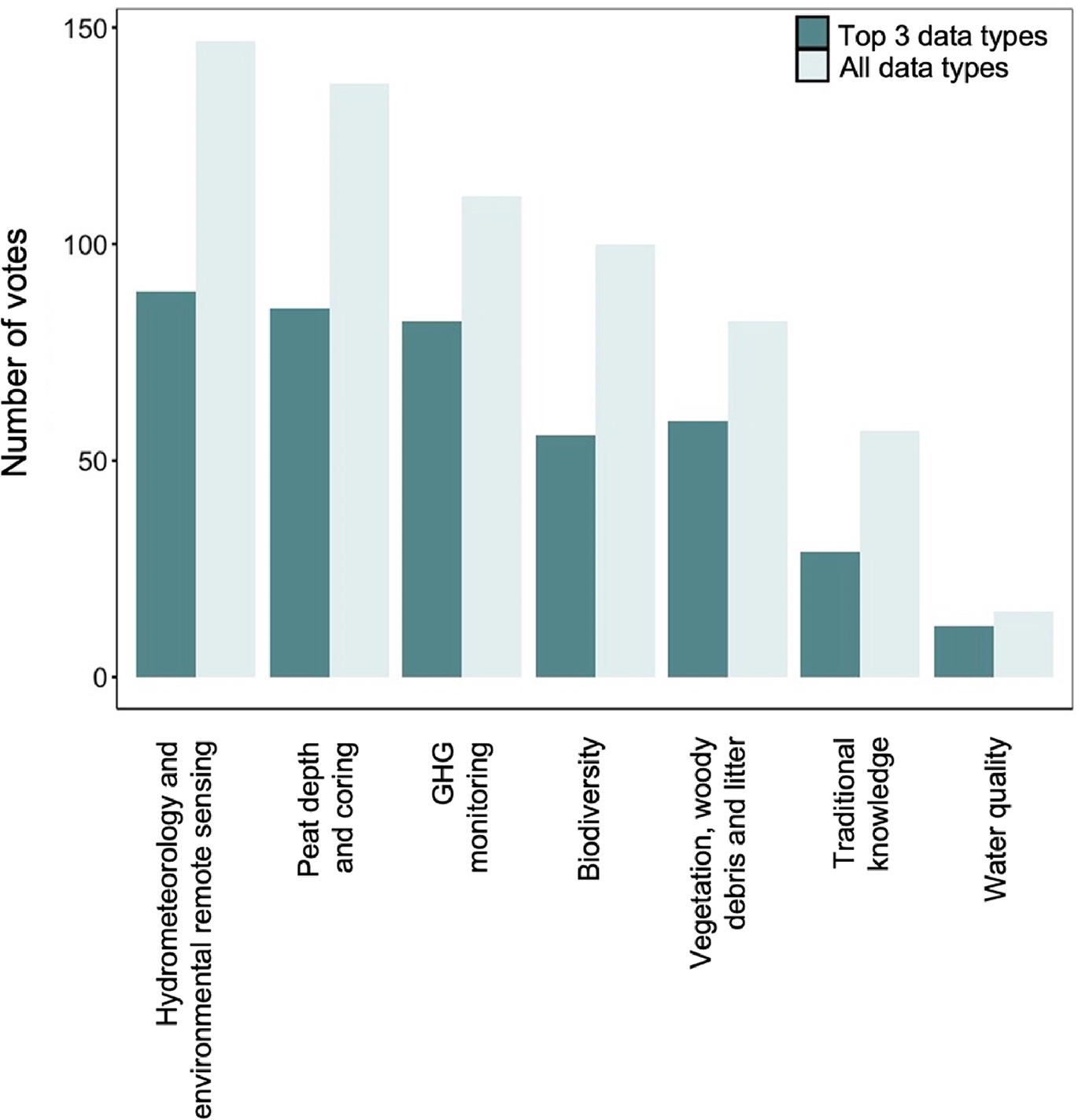
The following sections synthesize some of the key discussions from each of the groups for the different peatland data categories and the results of the prioritization exercise. The complete set of notes for each of the sections can be found in the supplemental material (Annex S2). The categories are considered in order of the number of votes (i.e., stickers) received in each category's top three data types (Fig. 2). This helps to account for the different number of data types reflected in each category. However, the order does not change significantly if the total number of votes across all data types is used as the metric, except the ranking of vegetation, wood debris, and litter switched with biodiversity (Fig. 2). In the two categories that received the least votes (Traditional Knowledge and water quality), we acknowledge that this likely reflects a lack of expertise in these areas among participants. We recognize that for these two categories, results represent incomplete information on the types of peatland information and how to collect that information.
Fig. 2.
3.1.1. Hydrometeorological and environmental sensing
Importance
Environmental variables, such as temperature and moisture, drive many key ecological and biogeochemical processes in peatlands (Yavitt et al. 1997; Turetsky et al. 2012; Page and Baird 2016). Notably, these factors drive water table fluctuations that influence microbial processes that control organic matter decomposition and nutrient cycling (Clymo 1984; Ise et al. 2008). In addition, soil temperature and moisture conditions determine oxidation-reduction potentials (amount of oxygen or other electron acceptors), which are important drivers of the amount and type of GHG emissions and rates of organic matter turnover (Marschner 2021). Meteorological conditions regulate these environmental controls and also affect vegetation–atmosphere processes such as evapotranspiration and gross primary productivity (Hesslerová et al. 2019). Understanding trends in these variables over time requires monitoring environmental conditions over event, seasonal, annual, and long-term time scales (Lindenmayer et al. 2012).
Discussion and recommendations
Water table depth, soil environmental conditions, and meteorological conditions were highlighted as priority measurements (Fig. 3).
Fig. 3.
Water table depth
Water table depth can be measured in a variety of ways within a dipwell, usually installed by hand, or hole dug in the peat, with water level measured via a blow tube, or dipwell with calibrated pressure transducers (Li and Gao 2020; Evans et al. 2021a, 2021b; Baird and Low 2022). At a minimum, data collection within peatlands should strive to include water table depth even if it is only a single measurement, although several measurements averaged across the peatland and at regular intervals in time is better. The simplest method is to make a small hole through the peat with a narrow diameter piece of tubing or solid probe. After the hole is created, time should be allowed for equilibration with the surrounding environment (Baird and Low 2022). Then, a hollow tube (or tubing attached to a rod) is lowered into the hole while blowing constantly until “bubbling” is heard. At this point, record the length of the tube to the peat surface (i.e., the total length of the tube minus the height above ground) to calculate the depth of the water table. If repeated measurements will be taken, installing a well (such as a PVC pipe with holes drilled along the entire length) is preferable.
Soil environmental conditions
Soil moisture was also identified as a priority measurement. There are a variety of probes that use capacitance or time domain reflectometry measurements (e.g., deltaT, WCR, etc.) that can be used synoptically or continuously to measure soil moisture (Cahn and Johnson 2017; Taufik et al. 2023) or an alternative low-tech option is to determine soil moisture gravimetrically by collecting peat samples (e.g., by taking a box core), weighing, drying, and then reweighing them to determine the mass of water (Baird and Low 2022). In practice, gravimetric measurements should be completed to calibrate probes as most manufacturer calibrations do not work well for peat soils (e.g., Dettmann and Bechtold 2018). Similarly, there are a variety of ways to measure soil temperature, from handheld thermometers to thermocouples and thermistors that can be connected to dataloggers or downloaded using Bluetooth or collected, downloaded, and redeployed (e.g., iButtons). For environmental conditions, consideration needs to be given as to the depth(s) at which data are collected as conditions fluctuate over various time scales.
Meteorological conditions
Precipitation (rain and snow) can be measured using a precipitation gauge, which could be made by simply using any clear plastic cylindrical bottle with a funnel and marking 1 cm increments, which must be read after a rainfall event and reset (Gires 2018). More complex systems that automatically measure the collected precipitation can be used to continuously measure precipitation in these systems if that is more aligned with the research goals (Richardson and Siccama 2000). Snow measurements can be more challenging to collect and could include heated precipitation collectors, or other methods such as using a camera with a graduated stick for scale, or snow depth surveys that account for snow water equivalents (Archer 1998).
3.1.2. Peat depth and coring
Importance
Peat depth and cores are used in peatland carbon accounting and mapping (pre-disturbance and post-reclamation/restoration) and in determining conservation, development, and land use policies (Loisel et al. 2014; Taillardat et al. 2020). Peat depths, along with bulk density, carbon and nutrient content, and degree of decomposition along the peat profile are used to calculate carbon stocks, and peat and carbon accumulation rates (Gorham et al. 2012). Peat cores can be used to determine the history and development of a site and its surroundings through radiometric dating, subfossil and microbial analysis, and chemical testing (e.g., Bilali et al. 2013; Packalen and Finkelstein 2014; Piilo et al. 2019). Furthermore, this peat profile information is essential to inform (parameterize, calibrate, and assess) peatland carbon models to understand past and present carbon dynamics and predict future responses because of direct anthropogenic changes and climate change (Gallego-Sala et al. 2018; Bauer et al. 2024).
Discussion and recommendations
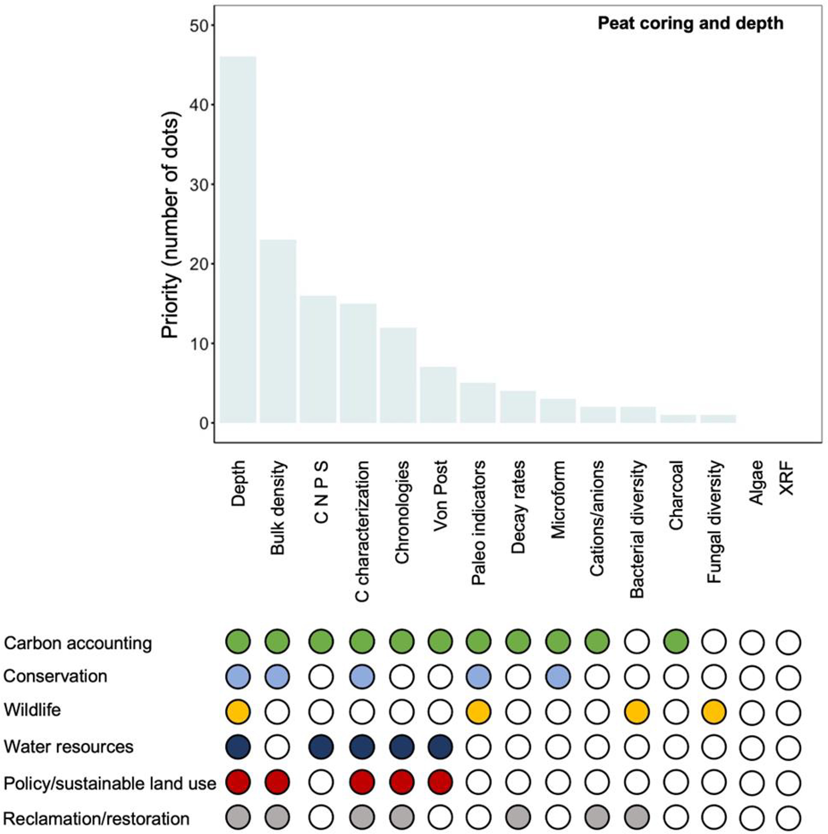
Peat depth, bulk density, and chemical characterization were highlighted as priority measurements (Fig. 4). Both bulk density determination and chemical characterization (as well as other peat properties) require the collection of peat cores.
Fig. 4.
Peat depth
There are multiple ways to sample peat depths in situ, with the simplest being a solid, narrow probe pushed down until resistance is met, signaling the mineral layer. Measuring from the point where the probe was at surface level (base of live moss layer, or if from the top of live layer indicate the depth of moss layer) to the bottom of the probe gives the peat depth. This method can be useful for quickly mapping peat depths using transects or a grid across a peatland, although there are some inherent uncertainties, including interference from large debris (e.g., rocks or buried wood), seasonal ground ice, permafrost, or ice lenses stopping the probe before the mineral layer is reached and thus recorded as too shallow. Taking multiple measurements at a single point using a narrow diameter corer is useful to remove the possibility that local debris is affecting the measurement and to ensure the peat–mineral interface has been reached (Parry et al. 2014).
Peat cores
The most common method for extracting peat samples is the collection of a peat core, in which a column of peat of known volume is extracted intact or in sections of known length. Although the outcome is the same, there are many variations in procedures and equipment used in the field for collecting peat, from many standardized instruments to any variety of homemade pipes, cylinders, and boxes. As many analyses across disciplines depend on sample volume, size, and continuous and (or) contiguous cores, standardizing collection procedures for low- and high-cost equipment options may be a priority (de Vleeschouwer et al. 2010; Shotyk and Noernberg 2020). Key considerations include whether the entire peat core should be collected or only a portion of the peat profile. Entire peat cores are extremely valuable but difficult and time-consuming to collect. Care should be taken when collecting cores to minimize the compression of the peat. Recording the depth of the core and the hole it was taken from may help estimate compression. Consideration should also be given to how many samples should be taken to be representative of the peatland. A general rule of thumb would be a minimum of three coring locations, with one core at the interior or deepest part of the peatland. Depending on the analyses to be done on the extracted peat cores, peat cores may need to be stored at specific temperatures (e.g., cool or frozen) or undergo special pre-analysis processing (e.g., cut into increments, dried, ground, preserved). Standard methods for characterizing wetland soil carbon stocks are being developed (e.g., Magnan et al. 2024).
Dry bulk density is needed to calculate peat C and nutrient pools (Renou-Wilson et al. 2022). Bulk density is calculated by taking a known volume of peat (cross-sectional area of corer multiplied by depth) and determining its dry weight. The optimal depth interval for measuring bulk density may vary, but frequently longer increments are used near the surface where density is lower, while shorter increments can be used at depth where density is higher. An optimal approach would be to take two cores, with one core for peat characterization and one core for bulk density estimation close to each other. A separate core for bulk density is often necessary since the heating required to dry the sample to determine mass and density may alter the chemical and biological characterization of the peat. Alternatively, subsamples can be taken if only one core is available, alternating subsections for characterizations and bulk density.
3.1.3. Greenhouse gas monitoring
Importance
Peatlands are important long-term carbon sinks but can also be sources of GHGs. Peatland plants draw down CO2 from the atmosphere via gross primary production (GPP) through photosynthesis but release CO2 via autotrophic respiration (AR). The balance between these two fluxes of CO2 is the net primary productivity (NPP) (Chapin et al. 2006). Heterotrophic respiration (HR) by microbes mineralizing dead organic matter produces CO2 and CH4 gases (Limpens et al. 2008). N2O production can also occur under certain conditions in peatlands, although exchanges of CO2 and CH4 dominate the peatland net ecosystem carbon balance. Monitoring of these important GHGs is required for carbon and GHG accounting and the policies that those applications support (Strack 2023). These measurements can be used to understand how peatlands respond to natural and anthropogenic disturbances, including forest fires, increasing air temperature, shifting precipitation patterns, and disturbance for industrial activities (e.g., Harris et al. 2020; Wilkinson et al. 2023), as well as the effectiveness of restoration efforts (e.g., Nugent et al. 2018; Satriawan et al. 2023).
Discussion and recommendations
GHG (CO2 and CH4) emissions and removals and primary productivity were highlighted as priority measurements (Fig. 5).
Fig. 5.
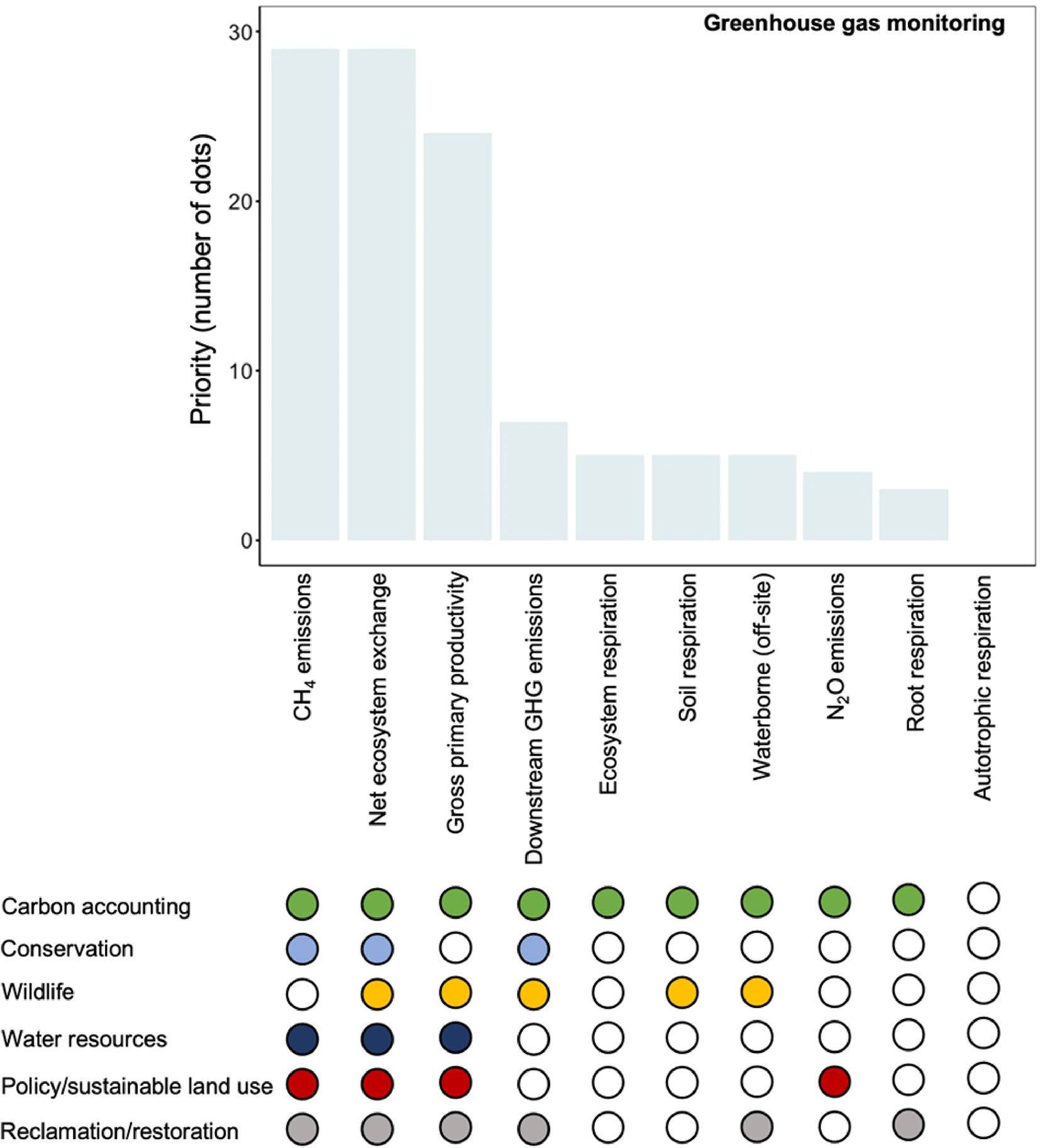
GHG emissions and removals
Measurements of net ecosystem exchange (NEE) of CO2 (NEE = GPP − AR − HR) and CH4 gases were the highest priority for session attendees. These variables can be directly measured and provide information about both the net quantity of gaseous CO2 or CH4 exchanged between the surface and the atmosphere, and the direction of the exchange. Measurement methods of CO2 and CH4 emissions can be divided into plot (<1 m2) versus ecosystem scale, and continuous versus non-continuous measurements. Employing methods at multiple spatial and temporal scales allows a variety of issues to be addressed, for example, how vegetation composition and moisture impact carbon emissions, how emissions vary diurnally and seasonally, and calculating emissions over a heterogenous landscape. At disturbed sites, researchers should consider not only the local emissions, but where applicable, also the downstream or down production chain emissions (where extracted material is processed) to capture the full impact of the disturbance. Bansal et al. (2023) provide an overview of measurement methods relevant to wetland carbon exchange.
The most common method is the use of static chambers to record plot-scale non-continuous CO2 and CH4 emissions. Plastic or aluminum chambers are manually placed onto collars inserted in the peat surface. The changes in gas concentration in the chamber headspace are measured for minutes to hours using trace gas analyzers (e.g., Bansal et al. 2023). A similar approach is the use of auto-chambers, which are connected to a power source and automatically open and close onto the collar, allowing for near continuous measurements without direct human involvement (e.g., Lai et al. 2012). Opaque and transparent chambers are used to partition this flux into its parts (see below). For example, the NEE of CO2 in the understory layer can be measured using clear chambers during the day, although this method does not account for aboveground AR or GPP in larger shrubs and trees.
The eddy covariance method is an alternative approach to plot-based chamber measurements and provides near-continuous ecosystem-scale measurements. The technique calculates the covariance in vertical fluctuations of trace gases (often CO2, CH4, and H2O) and wind velocity to estimate vertical fluxes of these gases between the surface and the atmosphere (e.g., Baldocchi 2014; Mauder et al. 2021). Since these measurements are taken above the tree canopy (if one is present), daytime eddy covariance measurements can capture both the canopy and understory NEE.
Ecosystem respiration (ER = AR + HR) can be measured using the chamber method with an opaque chamber, or under nighttime conditions with the eddy covariance method. However, separating ER into its two component fluxes is difficult. Soil HR can be measured by removing surface vegetation in a collar, and then using the chamber method with an opaque chamber; however, unless this vegetation removal is maintained or roots fully pulled out, the measurement will likely include some autotrophic root respiration and is thus not a true measure of HR (e.g., Rankin et al. 2023). Creating trenches around the base of the collar to limit the influence of adjacent vegetation roots on the collar fluxes can provide a more accurate HR value (Jovani-Sancho et al. 2018). Once HR is estimated, it can be subtracted from the measured ER to determine autotrophic root respiration (e.g., Munir et al. 2017).
Primary productivity
GPP and NPP were also identified as important variables. GPP is a derived value calculated by subtracting a measured ER from a measured NEE value collected using either chamber or eddy covariance methods. NPP can be calculated as GPP − AR, although in practice, it is very difficult to partition ER into AR and HR as discussed above. It can be also measured by tracking increases in plant biomass over time and then converting this biomass into carbon content (Strack et al. 2018).
3.1.4. Biodiversity inventory
Importance
Peatlands provide habitat for many plants, animals, invertebrates, and microorganisms. Biological diversity, or biodiversity, is defined as the variability among living organisms from all sources, including diversity within species, between species and of ecosystems (Convention on Biological Diversity 2011). Understanding species richness and diversity within peatlands is important for protecting these species and the ecological functions and services they provide. Peatlands are home to many plant species uniquely adapted to the wet, anoxic, and often acidic soil conditions. While this vegetation plays a key role in peatland carbon storage (see 3.3.5 Vegetation, woody debris, and litter section), it also provides habitat and forage for animals and humans, as well as traditional medicines (Mallon et al. 2016; Speller and Forbes 2022). Invertebrate and microbial communities also play critical roles in carbon and nutrient cycling in peatlands and are important lower trophic levels in local to regional food webs (Thormann 2006; Wyatt et al. 2021; Kamath et al. 2022; Allingham et al. 2023; Barreto et al. 2024). Additionally, peatlands provide habitat for many species at risk, and thus, understanding how these species use and interact with peatlands is important in developing species recovery plans. For example, habitat fragmentation across the boreal forest, particularly in peatlands, has been identified as a key contributor to declining woodland caribou populations (Courtois et al. 2007; Arsenault and Manseau 2011); and in Ontario, peatlands have been identified as key nesting and overwintering habitats for threatened reptile species (Markle et al. 2020).
Discussion and recommendations
Most participants at the workshop were not experts in invertebrate and (or) animal ecology, and thus the importance of biodiversity monitoring was likely under-represented in the prioritization exercise given the biases of the group. Vegetation inventory and linking that inventory to habitat for different organisms were rated as the highest priority measurements, followed by an inventory of other groups or organisms (Fig. 6). Vegetation inventory within this biodiversity category reflects some overlap with the “Vegetation, woody debris, and litter” category; although, when the focus is on assessing biodiversity, different measures are often used for plant species and plant species assemblages.
Fig. 6.
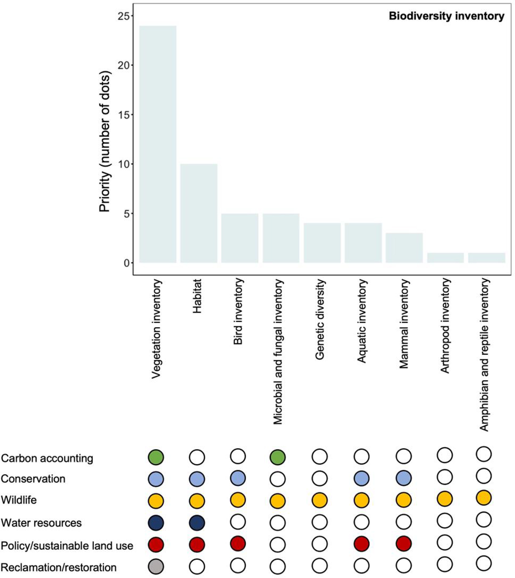
Different approaches to biodiversity inventories could be used depending on the purpose of the information. Some considerations include: (1) identification to species, genus, or family levels, use of functional group or trait-based approaches, or environmental DNA/RNA methods; (2) listing presence or absence or determining population size or percent cover; and (3) targeted surveys in specific areas or using opportunistic observations through crowdsourcing applications (e.g., iNaturalist) for regional inventory (e.g., Edaphobase).
Monitoring for many groups of organisms has advanced in recent years with the availability of camera traps and automatic recording units, yet data interpretation and on-the-ground field surveys continue to require highly trained experts (Stephenson 2020). However, these approaches reflect a Western science perspective and ignore traditional approaches and naming for biodiversity. Developing approaches that support the braiding of these knowledge systems will be valuable for advancing biodiversity monitoring in Canadian peatlands (Henri et al. 2021; Wilcox et al. 2023).
3.1.5. Vegetation, woody debris, and litter
Importance
Information on vegetation, woody debris, and litter is critical for accurate quantification of aboveground live carbon pools, estimating NPP, and quantifying dead organic matter pools on the peat surface (e.g., IPCC 2014; Bona et al. 2020). These data are also essential when classifying peatland type; characterizing species habitats, distributions, and abundance; and monitoring vegetation growth and successional trajectories over time (NWWG 1997; Warner and Asada 2006; Poulin et al. 2013; Baxendale et al. 2016; Pospíšilová et al. 2023).
Discussion and recommendations
Peatland type and vegetation cover, and biomass data were highlighted as priority measurements (Fig. 7).
Fig. 7.
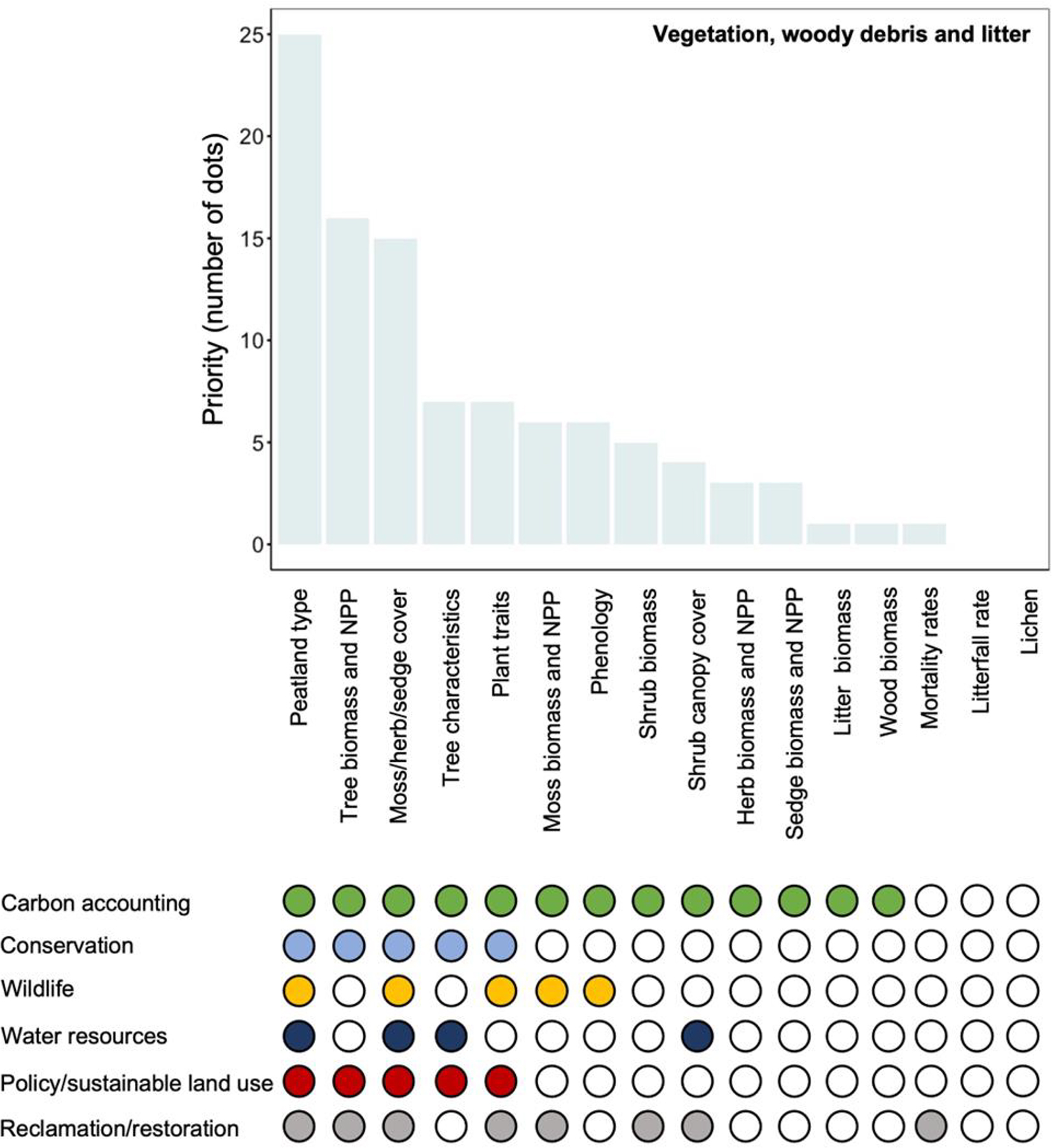
Vegetation cover and biomass
When collecting vegetation cover and biomass data, it is important to select appropriate plot sizes for each vegetation group. Ideally, understory vegetation plots should be nested; for example, 25 × 25 cm plots to identify mosses within a 1 × 1 m plot to identify vascular species (e.g., Gonzalez and Rochefort 2014). Plot sizes should, however, be adjusted to ensure that representative coverage of the various species within the site's community is obtained (Steenvoorden et al. 2022; Magnan et al. 2024). Further, allometric (diameter-height) equations that are peatland-specific would improve estimates of tree biomass (e.g., Bansal et al. 2023). For tracking vegetation change through time, permanent plots should be established, such as the plots used to monitor restoration outcomes on peat extraction sites (e.g., Poulin et al. 2013).
To understand the large spatial and temporal scale changes in vegetation cover, it is important that plot-scale measurements are both collected in a manner that can be linked to remote sensing products and that non-destructive techniques are used when possible. For example, plot- or field-scale measurements of tree structure and biomass can be linked to remote sensing products such as unpiloted aerial vehicle laser scanning (e.g., Brede et al. 2022). Furthermore, green leaf phenology (i.e., tracking the trajectory of plant greenness over the growing season; Davidson et al. 2021) and plant leaf traits, such as leaf area index, were also identified as potential ways to estimate NPP and biomass (Goud et al. 2017), while avoiding destructive sampling methods, which can be particularly challenging in remote locations, and can successfully be up-scaled using multi- and hyper-spectral remote sensing products (Davidson et al. 2016).
Peatland type
Peatland type is an integrative measure that is based on vegetation information (e.g., species present), direct measures of nutrient status (e.g., pH, conductivity, cation concentrations), and other information such as percent tree cover (e.g., NWWG 1997). Peatland type can be assigned using this information with relevant regional classification systems and guides (e.g., Alberta Environment and Sustainable Resource Development 2015; Government of Ontario 2022). Peatland-type identification is critical for scaling site-level information in national inventory models (e.g., Bona et al. 2020) and for verifying mapping products (e.g., Webster et al. 2018; Amani et al. 2019). However, peatland classification is challenging, particularly for the swamp category, and much work is still required to improve consistency across Canada (Webster et al. 2018).
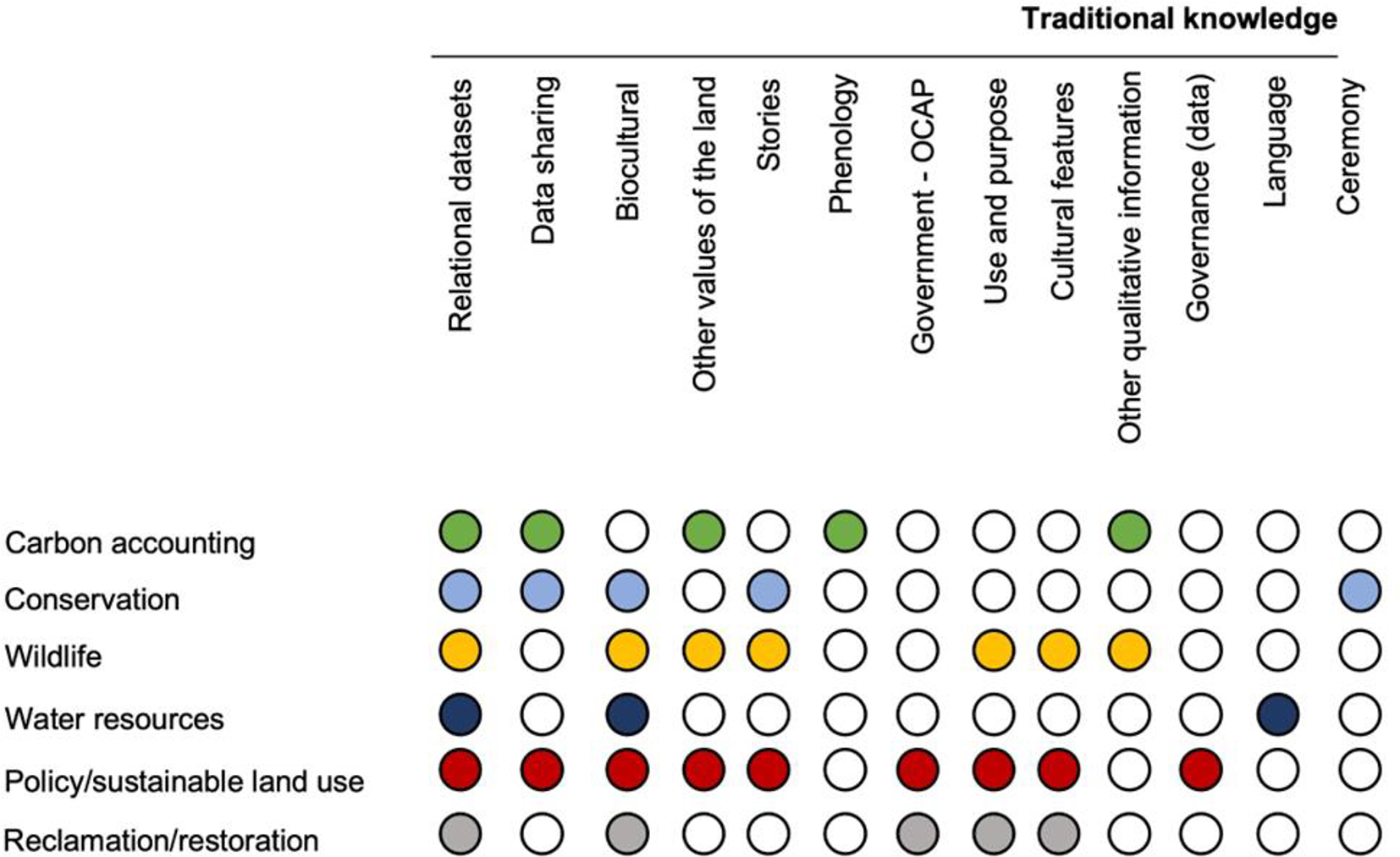
3.1.6. Traditional Knowledge
Importance
There is increased recognition of the importance of Traditional Knowledge and other ways of looking at the natural world and the importance of considering this different way of seeing as part of our path to reconciliation (TRCC 2015a, 2015b; Moola and Roth 2019; Wong et al. 2020). Only a few participants at the workshop had expertise in Traditional Knowledge, and we recognize that this is an important gap and does not cover the breadth of knowledge in this area.
Discussion and recommendations
Given that Traditional Knowledge was not represented well among the workshop participants and many, if not most participants, lack understanding of Traditional Knowledge, we have included the types of information discussed in the group, but not assigned a priority ranking (Fig. 8). Much more work is needed to advance efforts to weave this type of peatland information and knowledge with data types typically linked to Western science.
Fig. 8.
3.1.7. Water quality
Importance
The assessment of peatland water quality is an important tool in defining peatland types and their function. The biogeochemical characterization of these ecosystems can provide insights to processes in both upgradient (Rossi et al. 2012; Elmes et al. 2021) and downgradient (Ramchunder et al. 2011; Orlova and Branfireun 2014; Ferlatte et al. 2015) ecosystems. In the near surface, water quality can be both influenced by and in turn influence vegetation community productivity and composition (Lavallee and Campbell 2019; Serafin et al. 2023), while at depth, water quality can influence rates and types of decomposition (Beer et al. 2008; Leifeld et al. 2012), as well as the mixing of shallow and deep water sources (Balliston et al. 2023). Water-bound carbon can also be incorporated into carbon balances as a net carbon export from the peatland system (Waddington and Roulet 2000; Roulet et al. 2007; Gažovič et al. 2013; Taillardat et al. 2022; Prijac et al. 2023).
Discussion and recommendations
The water quality variables of porewater dissolved organic carbon (DOC), dissolved nutrients (e.g., nitrogen, phosphorus, sulfur), and measures that indirectly infer ionic concentrations, including alkalinity and conductivity, pH, and redox state were identified as priority measurements (Fig. 9).
Fig. 9.
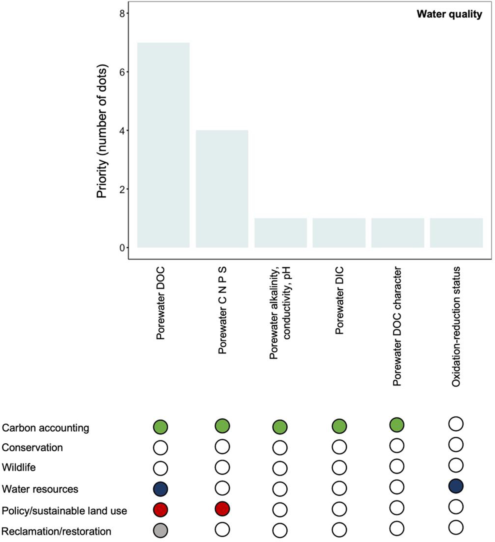
Water quality variables
Though specific techniques may vary by solute, water quality data are generally obtained by either deploying in situ sensors that continuously measure and record a given parameter or through the collection of ground or surface water samples, which are then analyzed either in-field or in a laboratory setting. Deployed in situ sensors are often used to capture a small number of variables at high temporal resolution and low spatial resolution, while water samples are often taken at discrete sampling events and better capture the spatial heterogeneity present across these landscapes. Common deployable sensors are cylindrical sondes that are generally housed in wells (e.g., perforated PVC pipes) and can be installed into both surface water features and soil profiles (Hensley et al. 2021).
Discrete water sampling is generally conducted from a well, piezometer (similar to wells, but perforations occur only at a specified depth), or grab sample from surface water (see Bansal et al. 2023 for more detailed descriptions of approaches). Water can be extracted manually using a purge tube equipped with a foot valve, or in an automated fashion using low-flow peristaltic pumps. Measurements may be taken in the field by extracting water into a sample cup and analyzing using a handheld water quality meter. If sample analysis is to occur in a laboratory, samples are collected into cleaned and rinsed sample bottles according to specifications for the solute. Many water quality variables require the samples to be stored at specific temperatures (e.g., freezing) to prevent the degradation of the sample before analysis. Some samples, such as those collected for the analysis of DOC (Moore 1987; Urban et al. 1989; Prijac et al. 2022), may need further processing before storage and analysis, such as filtering, dilution, and (or) acidification. Given that some water quality variables can change form or degrade over time, analyses may be time-sensitive and must be completed within a certain window of time.
4. Discussion
Three themes emerged from the summary and syntheses part of the workshop: (1) priority data/information common among peatland applications, (2) capturing temporal variability and spatial heterogeneity in data/information, and (3) peatland data acquisition and data mobilization and management.
4.1. Priority data/information common among peatland applications
Scanning across all the types of peatland information that were considered during the workshop, the following were highlighted as priority measurements (Table 1). We recognize there are some limitations to our approach and the choice of priority measurements likely reflect biases in expertise and applications of the participants, including the representation of Indigenous views and perspectives. Furthermore, aside from a few exceptions, each data subcategory had at least one vote, so many different data are recognized as important. Despite this limitation, this is an important first step in moving forward with standardized data collection protocols for peatland measurements and data.
Table 1.
| Category | Measurements |
|---|---|
| Peat coring and depth | Peat depth |
| Bulk density | |
| Nutrient concentration | |
| Hydrometeorological and environmental sensing | Water table |
| Soil moisture and temperature | |
| Precipitation | |
| GHG monitoring | CO2 emissions and removals (NEE) |
| CH4 | |
| GPP/NPP | |
| Vegetation, woody debris, and litter | Peatland type |
| Tree biomass | |
| Moss, herb, sedge % cover | |
| Biodiversity | Vegetation inventory |
| Habitat | |
| Animal inventory | |
| Water quality | DOC |
| Porewater nutrients | |
| Alkalinity/conductivity/pH |
Note: Note: NEE is net ecosystem exchange, GPP is gross primary productivity, NPP is net primary productivity.
In each of these categories some low-technology/readily available options to measure these key pieces of information were identified. These techniques may be appropriate for deployment by non-specialists (e.g., in a community science approach), but future work should focus on the accuracy and precision of the data produced (e.g., North et al. 2023). Further, while these approaches are inexpensive and simple to deploy, if an understanding of temporal variation is required, this would require frequent site visits. Frequent site visits may pose significant logistical challenges if the site is remote or only seasonally accessible; however, this could be addressed in part through more Indigenous partnerships and training to enhance the capacity to collect data in Traditional Territories, especially in areas around traditional camps. There were also high-tech options for taking these measurements; however, these options were not only more expensive but required more expertise to deploy and maintain, and frequently required a power source (e.g., solar panels and deep cycle batteries). Although more expensive and technically intense to maintain, these systems could allow higher temporal resolution in monitoring and could be left unattended for longer periods. However, there are risks associated with loss of data if systems fail (e.g., power outages) or are damaged (e.g., by wind or animals).
4.2. Capturing temporal variability and spatial heterogeneity in data/information
For either low-tech or high-tech options, year-round monitoring of peatlands is often problematic, particularly in cold climates. Capturing conditions and responses during the non-growing season is a critical gap in collecting peatland information. There is no easy solution to this, although establishing more peatland sites that are easily accessible year-round (e.g., Mer Bleue, Burns Bog) would be of tremendous value and more partnerships with Indigenous communities on Traditional Territories could enhance this effort. There is also enormous value in ensuring that these sites are maintained long-term to capture trends and tipping points over time (Havstad and Herrick 2003; Lindenmayer and Likens 2010; Lindenmayer et al. 2012).
Peatland data and information are often only collected at the plot or site/peatland scale. Understanding how those peatland properties scale from the plot to site, to other peatlands of the same type—both within and among ecozones—is a critical gap (Webster et al. 2018). Currently, there is a low density of peatland information across Canada, with bias to information in southern regions that can be more easily accessed. Again, although there is no easy solution to this gap, designing a network to monitor replicated peatland sites within and among ecozones would be valuable to understanding variability in peatland patterns and processes across scales (Minasny et al. 2023). To facilitate data compilation, it is also important that standard contextual information (e.g., geographic coordinates, peatland type) is recorded and consistently reported alongside the priority data types identified in Table 1. Continued efforts to better map the distribution of different peatland types (e.g., Government of Canada 2024) will aid in identifying where gaps exist in peatland data. Advancements in, and application of, remote sensing technologies (e.g., O'Leary et al. 2022) will be critical to mapping and filling these gaps.
4.3. Peatland data acquisition and data mobilization and management
Based on the experts’ discussions, it was clear that there is a need for the acquisition of more peatland data, particularly of the high-priority measurements identified. Participants identified various methods to measure different peatland parameters. Different methods have “pros” and “cons” for their use, depending on the purpose for which the information will be used and the expertise of those collecting the information. Therefore, there is a need to create standardized, yet flexible, protocols and best practices for measuring different peatland variables to promote consistent methodology (Beard et al. 1999). The Can-Peat project (https://uwaterloo.ca/can-peat/network) is working towards creating a repository of protocols for measuring different peatland parameters to which people can contribute. A recent review paper by Bansal et al. (2023) on “Practical guide to measuring wetland carbon pools and fluxes” can serve as a good resource for those interested in carbon accounting. Standardized and easy approaches for making peatland measurements also means that crowdsourcing or citizen science can aid in the collection of peatland data (e.g., Tracking the Colour of Peatlands: community science project; Davidson 2024). Lastly, systematically weaving Traditional Knowledge on peatlands and engaging Indigenous land stewards to collaborate on knowledge generation and sharing could also improve this knowledge gap. This work needs to be guided by the 2015 Truth and Reconciliation Commission's (TRC) final report (TRCC 2015a) and 94 Calls to Action (TRC 2015b), as well as adoption of Bill C-15: An Act respecting the United Nations Declaration on the Rights of Indigenous Peoples in 2021. As proposed in the 2023 Blueprint for Forest Carbon Science in Canada (Smyth et al. 2024), this could be facilitated through Indigenous-led research that is centred on Indigenous voices and experiences and application of Traditional Knowledge systems. This will require changes to research practices and collaborations to be respectful to Indigenous Peoples and Indigenous methodologies, which can only be achieved through authentic and respectful Indigenous engagement (Smyth et al. 2024).
The workshop results demonstrated that many types of peatland data and information are used for different applications. Two ECCC initiatives related to data collection and fieldwork planning were highlighted at the workshop. The ECCC Wetland Survey tool on ESRI Survey123 has been developed for collecting a variety of peatland information; Survey 123 is an app available from wherever you download your applications and can be installed onto a cell phone or a handheld GPS. After installing Survey 123, entering the address https://portal.nwrc.carleton.ca/arcgis will connect to the survey. The survey is set to public and selecting “continue without signing in” will allow access to the survey. All observations, photos, and measurements are kept together and linked via location and GPS point ID. Data collected can be sent to partners and will be available via web map for observation and downloading. Not all fields of the forms need to be filled, and thus, it is flexible enough to capture whatever information is possible based on one's expertise and time availability. The only mandatory questions are name, email, and key contextual information such as GPS point, date, and site photos.
The second initiative, co-developed by the Mushkegowuk Council of the Omushkego Cree, ECCC, and Parks Canada, is a tool to assist with planning and coordinating fieldwork in the Hudson Bay Lowlands (Yehewin Aski: The Breathing Lands–Hudson Bay Lowlands Field Planning application). This application allows researchers and their staff to input information related to location and type of information that will be collected on their field trip. Additional project information (i.e., title, team lead, contact information, activity objectives, description of activities, dates, equipment, team skill sets, and safety protocols) can also be included. Better knowledge of new planned acquisitions can benefit from value-added research being done on a core set of samples (e.g., molecular eDNA information on samples collected for nutrient analyses). Coordinating field collections ensures that financial resources are used more effectively and efficiently.
The intellectual value of collected peatland data is high, and having mechanisms to share data would be useful. There is a long history of wetland research in Canada (e.g., Price et al. 2023), but existing data are not always easily accessible or interoperable. In addition to coordinating new data collections, efforts to create atlases of historical and contemporary data collections, and creating a data hub of peatland information and databases will greatly improve opportunities to coordinate and collaborate on peatland-related topics. This effort is also being supported by the Can-Peat project, but funding beyond short-term project commitments is needed to ensure the longevity of developed products. These types of products and tools, alongside national legislation and policies that support them, will take time to develop and will need to carefully consider issues such as data use, sharing, acknowledgment, location sensitivity, and restrictions, including Indigenous data sovereignty.
Discussion among the participants of the workshop showed a willingness and eagerness to collaborate on all aspects of peatland conservation and management. Engagement and coordination of people through the Can-Peat network will be an important opportunity to leverage future investment in peatland monitoring and data collection. This network of peatland researchers and practitioners could build the foundation towards new initiatives such as coordinating a “blitzing” of core peatland measurements across Canada or leading the creation of a network of peatland “super sites” that measure core data/information at a higher temporal frequency and over the longer term. The passion and enthusiasm for increasing peatland knowledge and applying it to many scientific, management, conservation, and policy issues was clear among the participants. We must continue to expand our knowledge and understanding of these important ecosystems in a changing world. This is particularly relevant for Canadians as we are the stewards of one-quarter of the world's peatlands, much of which exists in a relatively pristine state.
Conclusions
It is clear that the need for peatland data is pressing for many different applications; however, collecting these data is challenging given the vast extent of Canada's peatlands, and that human and financial resources are few. Different types of peatland data and information are required for different applications and questions, but core needs among applications were highlighted. Furthermore, critical steps towards collecting peatland data accessible to a variety of end-users to address the many peatland-related challenges being faced were identified. This emerging scientific consensus included:
•
Create standardized, yet flexible protocols for data collection. Make these protocols available, and create a forum for sharing protocols and best practices for collecting data.
•
Coordinate field data collection where possible, ensure that appropriate contextual information (e.g., geographic coordinates, elevation, date) is recorded and included in data records, and consider collecting other important types of data that could benefit others.
•
Collect data while keeping in mind that it might be able to be used for other applications (e.g., modelling and remote sensing).
•
Weave more Traditional Knowledge into knowledge on peatlands.
•
Engage new partners, including Indigenous communities, to gather data, information, and knowledge on peatlands.
•
Create an atlas of past and current peatland data collections. Include metadata and links to data, and (or) create a data hub to link to data or databases. Support the maintenance of this tool.
•
Scope opportunities to create a network of peatland “super sites” (or Long-Term Ecological Research sites) that measure many different peatland variables frequently and over the long term reflecting peatland type and ecoregion diversity across Canada.
Acknowledgements
The authors would like to thank all of the participants of the GPI-RE3 peatland data and knowledge workshop, including Frederic Caron, Raphaël Deragon, Fannie Desrosiers, Paula Figueroa Delgado, Louis Gilet, Chloé Griaud, Markus Merkens, Trevor Paul, Emily Prystupa, Jade Skye, Alexandra Tekatch, and all other anonymous participants. We would like to acknowledge GPI, Can-Peat, and PERG for organizing and funding the workshop. This research was part of Can-Peat: Canadian peatlands as nature-based climate solutions. The Government of Canada's Environmental Damages Fund provided funding for this project under its Climate Action and Awareness Fund. Funding was granted for Project# EDF-CA-2021i005.
References
Alberta Environment and Sustainable Resource Development (ESRD). 2015. Alberta Wetland Classification System. Water Policy Branch, Policy and Planning Division, Edmonton, Alberta.
Allingham S.M., Nwaishi F.C., Andersen R., Lamit L.J., Elliot D.R. 2023. Microbial communities and biogeochemical functioning across peatlands in the Athabasca Oil Sands region of Canada: implications for reclamation and management. Land Degradation and Development, 34(5): 1504–1521.
Amani M., Mahdavi S., Afshar M., Brisco B., Huang W., Mohammad Javad Mirzadeh S., et al. 2019. Canadian wetland inventory using Google Earth Engine: the first map and preliminary results. Remote Sensing, 11(7): 842.
Archer D. 1998. Snow measurement. In Encyclopedia of hydrology and lakes. Encyclopedia of earth science. Springer, Dordrecht. pp. 618–621.
Arsenault A.A., Manseau M. 2011. Land management strategies for the long-term persistence of boreal woodland caribou in central Saskatchewan. Rangifer, 31(2): 33–48.
Baird A.J., Low R.G. 2022. The water table: its conceptual basis, its measurement and its usefulness as a hydrological variable. Hydrological Processes, 36(6): e14622.
Baldocchi D. 2014. Measuring fluxes of trace gases and energy between ecosystems and the atmosphere—the state and future of the eddy covariance method. Global Change Biology, 20(12): 3600–3609.
Balliston N., Sutton O., Price J. 2023. Solute depletion and reduced landscape connectivity in subarctic patterned peatlands disturbed by mine dewatering. Science of The Total Environment, 913: 169442.
Bansal S., Creed I.F., Tangen B.A., Bridgham S.D., Desai A.R., Krausset K.W., et al. 2023. Practical guide to measuring wetland carbon pools and fluxes. Wetlands, 43: 105.
Barreto C., Buchkowski R., Lindo Z. 2024. Restructuring of soil food webs reduces carbon storage potential in boreal peatlands. Soil Biology and Biochemistry, 193: 109413.
Bauer I.E., Davies M.A., Bona K.A., Hararuk O., Shaw C.H., Thompson D.K., et al. 2024. Peat profile database from peatlands in Canada. Ecology, e4398.
Baxendale C.L., Ostle N.J., Wood C.M., Oakley S., Ward S. 2016. Can digital image classification be used as a standardized method for surveying peatland vegetation cover? Ecological Indicators, 68: 150–156.
Beard G.R., Scott W.A., Adamson J.K. 1999. The value of consistent methodology in long-term environmental monitoring. Environmental Monitoring and Assessment, 54: 239–258.
Beer J., Lee K., Whiticar M., Blodau C. 2008. Geochemical controls on anaerobic organic matter decomposition in a northern peatland. Limnology and Oceanography, 53(4): 1393–1407.
Bilali H.E., Patterson R.T., Prokoph A. 2013. A Holocene paleoclimate reconstruction for eastern Canada based on δ18O cellulose of Sphagnum mosses from Mer Bleue Bog. The Holocene, 23(9): 1260–1271.
Bona K.A., Shaw C., Thompson D.K., Hararuk O., Webster K., Zhang G., et al. 2020. The Canadian model for peatlands (CaMP): a peatland carbon model for national greenhouse gas reporting. Ecological Modelling, 431: 109164.
Bona K.A., Webster K.L., Thompson D.K., Hararuk O., Zhang G., Kurz W.A. 2024. Using the Canadian Model for Peatlands (CaMP) to examine greenhouse gas emissions and carbon sink strength in Canada's boreal and temperate peatlands. Ecological Modelling, 490: 110633.
Brede B., Terryn L., Barbier N., Bartholomeus H.M., Bartolo R., Calders K., et al. 2022. Non-destructive estimation of individual tree biomass: allometric models, terrestrial and UAV laser scanning. Remote Sensing of Environment, 280: 113180.
Brown I. 2020. Challenges in delivering climate change policy through land use targets for afforestation and peatland restoration. Environmental Science and Policy, 107: 36–45.
Cahn M., Johnson L. 2017. New approaches to irrigation scheduling of vegetables. Horticulturae, 3(2): 28.
Canadian Council of Ministers of Environment. 2011. Protocols manual for water quality sampling in Canada. PN 1461. ISBN 978-1-896997-7-0 PDF.
Chapin F.S., Woodwell G.M., Randerson J.T., Rastetter E.B., Lovett G. M., Baldocchi D.D., et al. 2006. Reconciling carbon-cycle concepts, terminology, and methods. Ecosystems, 9(7): 1041–1050.
Cimellaro M. 2022. ‘Yehewin Aski’: the breathing lands: Protecting Canada from climate breakdown. Nature Canada. Available from https://naturecanada.ca/news/blog/yehewin-aski-protecting-canada-from-climate-breakdown/ [accessed 18 December 2024].
Clymo R.S. 1984. The limits to peat bog growth. Philosophical Transactions of the Royal Society of London. B, Biological Sciences, 303(1117): 605–654.
Convention on Biological Diversity 2011. Convention on Biological Diversity: Text and Annexes. Secretariat of the Convention on Biological Diversity: Montreal, Canada. Available from https://www.cbd.int/doc/legal/cbd-en.pdf [accessed 18 December 2024].
Courtois R., Ouellet J.P., Breton L., Gingras A., Dussault C. 2007. Effects of forest disturbance on density, space use, and mortality of woodland caribou. Ecoscience, 14(4): 491–498.
Davidson S.J. 2024. Tracking the Colour of Peatlands project [online]. Available from https://www.plymouth.ac.uk/research/plymouth-peatland-research-group/tracking-the-colour-of-peatlands-project [accessed 6 September 2024].
Davidson S.J., Goud E.M., Malhotra A., Estey C.O., Korsah P., Strack M. 2021. Linear disturbances shift boreal peatland plant communities toward earlier peak greenness. Journal of Geophysical Research: Biogeosciences, 126(8): e2021JG006403.
Davidson S.J., Santos M.J., Sloan V.L., Watts J.D., Phoenix G.K., Oechel W.C., et al. 2016. Mapping Arctic tundra vegetation communities using field spectroscopy and multispectral satellite data in North Alaska, U.S.A. Remote Sensing, 8(12): 978.
De Vleeschouwer F., Chambers F.M., Swindles G.T. 2010. Coring and sub-sampling of peatlands for palaeoenvironmental research. Mires and Peat, 7: 1–10.
Dettmann U., Bechtold M. 2018. Evaluating commercial moisture probes in reference solutions covering mineral to peat soil conditions. Vadose Zone Journal, 17: 170208.
Drever C.R., Cook-Patton S.C., Akhter F., Badiou P.H., Chmura G.L., Davidson S.J., et al. 2021. Natural climate solutions for Canada. Science Advances, 7(23): eabd6034.
Elmes M.C., Davidson S.J., Price J.S. 2021. Ecohydrological interactions in a boreal fen–swamp complex, Alberta, Canada. Ecohydrology, 14(7): e2335.
EPA (United States Environmental Protection Agency). 2023. Environmental Measures and Modelling. Available from https://www.epa.gov/measurements-modeling/collection-methods [accessed 24 March 2024].
Evans C.D., Peacock M., Baird A.J., Artz R.R.E., Burden A., Callaghan N., et al. 2021a. Overriding water table control on managed peatland greenhouse gas emissions. Nature (London), 593(7860): 548–552.
Evans C.D., Callaghan N., Jaya A., Grinham A., Sjogersten S., Page S.E., et al. 2021b. A novel low-cost, high-resolution camera system for measuring peat subsidence and water table dynamics. Frontiers in Environmental Science, 9: 630752.
Ferlatte M., Quillet A., Larocque M., Cloutier V., Pellerin S., Paniconi C. 2015. Aquifer–peatland connectivity in southern Quebec (Canada). Hydrological Processes, 29(11): 2600–2612.
Frolking S., Roulet N.T. 2007. Holocene radiative forcing impact of northern peatland carbon accumulation and methane emissions. Global Change Biology, 113: 1079–1088.
Gallego-Sala A.V., Charman D.J., Brewer S., Page S.E., Prentice I.C., Friedlingstein P., et al. 2018. Latitudinal limits to the predicted increase of the peatland carbon sink with warming. Nature Climate Change, 8(10): 907–913.
Gažovič M., Forbrich I., Jager D.F., Kutzbach L., Wille C., Wilmking M. 2013. Hydrology-driven ecosystem respiration determines the carbon balance of a boreal peatland. The Science of the Total Environment, 463: 675–682.
Gires A. 2018. How do we measure rainfall? Frontiers for Young Minds, 6: 38.
González E., Rochefort L. 2014. Drivers of success in 53 cutover bogs restored by a moss layer transfer technique. Ecological Engineering, 68: 279–290.
Gorham E., Lehman C., Dyke A., Clymo D., Janssens J., 2012. Long-term carbon sequestration in North American peatlands.Quaternary Science Reviews, 58: 77–82.
Goud E.M., Moore T.R., Roulet N.T. 2017. Predicting peatland carbon fluxes from non-destructive plant traits. Functional Ecology, 31(9): 1824–1833.
Government of Canada. 2023. Canada's Nature Legacy: Protecting Nature. Available from https://www.canada.ca/en/services/environment/conservation/nature-legacy.html [accessed 24 March 2024].
Government of Canada. 2024. Canadian National Wetlands Inventory. Environment and Climate Change Canada. Available from https://www.canada.ca/en/environment-climate-change/services/wildlife-habitat/canadian-national-wetland-inventory.html [accessed 18 December 2024].
Government of Ontario. 2022. Ontario Wetland Evaluation System—Northern Manual 2nd Edition. King's Printer for Ontario, Ontario. 246p.
Harris L.I., Richardson K., Bona K.A., Davidson S.J., Finkelstein S.A., Garneau M., et al. 2022. The essential carbon service provided by northern peatlands. Frontiers in Ecology and the Environment, 20(4): 222–230.
Harris L.I., Roulet N.T., Moore T.R. 2020. Drainage reduces the resilience of a boreal peatland. Environmental Research Communications, 2(6): 065001.
Havstad K.M., Herrick J.E. 2003. Long-term ecological monitoring. Arid Land Research and Management, 17(4): 389–400.
Henri D.A., Provencher J.F., Bowles E., Taylor J.J., Steel J., Chelick C., et al. 2021. Weaving Indigenous knowledge systems and Western sciences in terrestrial research, monitoring and management in Canada: a protocol for a systematic map. Ecological Solutions and Evidence, 2: e12057.
Hensley R., Harrison N., Goodman K., Cawley K., Litt G., Nance B., et al. 2021. A comparison of water quality sensor deployment designs in wadeable streams. Limnology and Oceanography: Methods, 19(10): 673–681.
Hesslerová P., Pokorný J., Huryna H., Harper D. 2019. Wetlands and forests regulate climate via evapotranspiration. In Wetlands: ecosystem services, restoration and wise use. Ecological studies. Vol 238. Edited by S. An, J. Verhoeven. Springer, Cham.
Indigenous Circle of Elders. 2018. We Rise Together: Achieving Pathway to Canada Target 1 through the creation of Indigenous Protected and Conserved Areas in the spirit and practice of reconciliation. The Indigenous Circle of Experts’ report and recommendations, March 2018. Available from https://static1.squarespace.com/static/57e007452e69cf9a7af0a033/t/5ab94aca6d2a7338ecb1d05e/1522092766605/PA234-ICE_Report_2018_Mar_22_web.pdf [accessed 18 December 2024].
IPCC (Intergovernmental Panel on Climate Change). 2014. 2013 Supplement to the 2006 IPCC Guidelines for National Greenhouse Gas Inventories: Wetlands. Edited by T. Hiraishi, T. Krug, K. Tanabe, N. Srivastava, J. Baasansuren, M. Fukuda, et al. Intergovernmental Panel on Climate Change (IPCC), Switzerland.
IPCC (The Intergovernmental Panel on Climate Change). 2021. Summary for policymakers. In Climate Change 2021: The Physical Science Basis. Contribution of Working Group I to the Sixth Assessment Report of the Intergovernmental Panel on Climate Change. Edited by V. MassonDelmotte, P. Zhai, A. Pirani, S.L. Connors, C. Péan, S. Berger, et al. Cambridge University Press, Cambridge, United Kingdom and New York, NY, USA. Available from http://hdl.handle.net/10204/12710 [accessed 18 December 2024].
Ise T., Dunn A.L., Wofsy S.C., Moorcroft P.R. 2008. High sensitivity of peat decomposition to climate change through water-table feedback. Nature Geoscience, 1(11): 763–766.
IUCN (International Union for Conservation of Nature). 2021. Peatlands and Climate Change. International Union for Conservation of Nature Issues Brief, Gland, Switzerland.
Joosten H. 2015. Peatlands, climate change mitigation and biodiversity conservation: an issue brief on the importance of peatlands for carbon and biodiversity conservation and the role of drained peatland as greenhouse gas emission hotspots. Nordic Council of Ministers: Climate and Air Pollution Group (KOL), Terrestrial Ecosystem Group (TEG). Copenhagen, Nordisk Ministerråd. 14p.
Jovani-Sancho A.J., Cummins T., Byrne K.A. 2018. Soil respiration partitioning in afforested temperate peatlands. Biogeochemistry, 141: 1–21.
Kamath D., Barreto C., Lindo Z. 2022. Nematode contributions to the soil food web trophic structure of two contrasting boreal peatlands in Canada. Pedobiologia, 93–94: 150809.
Lai D.Y.F., Roulet N.T., Humphreys E.R., Moore T.R., Dalva M. 2012. The effect of atmospheric turbulence and chamber deployment period on autochamber CO2 and CH4 flux measurements in an ombrotrophic peatland. Biogeosciences, 9: 3305–3322.
Lavallee A., Campbell D. 2019. Effects of simulated treated domestic wastewater on Sphagnum productivity, decomposition and nutrient dynamics in a subarctic ladder fen. Wetlands, 39(1): 29–38.
Leifeld J., Menichetti L. 2018. The underappreciated potential of peatlands in global climate change mitigation strategies. Nature Communications, 9: 1071.
Leifeld J., Steffens M., Galego-Sala A. 2012. Sensitivity of peatland carbon loss to organic matter quality. Geophysical Research Letters, 39(14): L14704.
Li Z., Gao P. 2020. Characterizing spatially variable water table depths in a disturbed Zoige peatland watershed. Journal of Hydro-Environment Research, 29: 70–79.
Limpens J., Berendse F., Blodau C., Canadell J. G., Freeman C., Holden J. 2008. Peatlands and the carbon cycle: from local processes to global implications—a synthesis. Biogeosciences, 5(5): 1475–1491.
Lindenmayer D.B., Likens G.E. 2010. The science and application of ecological monitoring. Biological Conservation, 143(6): 1317–1328.
Lindenmayer D.B., Likens G.E., Andersen A., Bowman D., Bull C.M., Burns E., et al. 2012. Value of long-term ecological studies. Austral Ecology, 37(7): 745–757.
Loisel J., Yu Z., Beilman D.W., Camill P., Alm J., Amesbury M.J., et al. 2014. A database and synthesis of northern peatland soil properties and Holocene carbon and nitrogen accumulation. The Holocene, 24(9): 1028–1042.
Magnan G., Garneau M., Beaulne J., Lavoie M., Pellerin S., Perrier L., et al. 2023. A simple field method for estimating the mass of organic carbon stored in undisturbed wetland soils. Mires & Peat, 29(8): 1–13.
Magnan G., Garneau M., Perrier L., Beaulne J., Sanderson N.K., Primeau G., Lachance D. 2024. Inventory guide for estimating carbon stocks in wetlands—May 2024 version, Québec, Ministère de l'Environnement, de la Lutte contre les changements climatiques, de la Faune et des Parcs, Direction des milieux humides, 20 pages + appendices. ISBN: 978-2-550-96333-2. Available from https://www.environnement.gouv.qc.ca/eau/rives/guide-inventaire-estimation-carbone-milieux-humides-en.pdf [accessed 18 December 2024].
Mallon E.E., Turetsky M.R., Thompson I.D., Fryxell J.M., Wiebe P.A. 2016. Effects of disturbance on understory succession in upland and lowland boreal forests and implications for woodland caribou (Rangifer tarandus caribou). Forest Ecology and Management, 364, 17–26.
Markle C.E., Moore P.A., Waddington J.M. 2020. Primary drivers of reptile overwintering habitat suitability: integrating wetland ecohydrology and spatial complexity. Bioscience, 70: 597–609.
Marschner P. 2021. Processes in submerged soils—linking redox potential, soil organic matter turnover and plants to nutrient cycling. Plant and Soil, 464, 1–12.
Mauder M., Foken T., Aubinet M., Ibrom A. 2021. Eddy-covariance measurements. In Springer Handbook of Atmospheric Measurments. Edited by T. Froken. Springer Handbooks. Springer, Cham. pp. 1473–1504.
Minasny B., Adetsu D.V., Aitkenhead M., Artz R.R., Baggaley N., Barthelmes A., et al. 2023. Mapping and monitoring peatland conditions from global to field scale. Biogeochemistry, 167: 383–425.
Minayeva T.Y., Sirin A.A. 2012. Peatland biodiversity and climate change. Biology Bulletin Reviews, 2: 164–175.
Mitchell M.G.E., Schuster R., Jacob A.I., Hanna D.E.L., Ouellet Dallaire C., Raudsepp-Hearne C., et al. 2021. Identifying key ecosystem service providing areas to inform national-scale conservation planning. Environmental Research Letters, 16: 014038.
Moola F., Roth R. 2019. Moving beyond colonial conservation models: Indigenous protected and Conserved Areas offer hope for biodiversity and advancing reconciliation in the Canadian boreal forest. Environmental Reviews, 27(2): 200–201.
Moore T.R. 1987. Patterns of dissolved organic matter in subarctic peatlands. Earth Surface Processes and Landforms, 12(4): 387–397.
Moxey A., Smyth M.A., Taylor E., Williams A.P. 2021. Barriers and opportunities facing the UK Peatland Code: a case-study of blended green finance. Land Use Policy, 108: 105594.
Munir T.M., Khadka B., Xu B., Strack M. 2017. Partitioning forest-floor respiration into source based emissions in a boreal forested bog: responses to experimental drought. Forests, 8(3): 75.
North T., Moore P., Birch W., Markle C., Freeman H., Furukawa A., et al. 2023. iWetland: a community science platform for monitoring wetland water levels. Citizen Science: Theory and Practice, 8(1): 7.
Nugent K.A., Strachan I.B., Strack M., Roulet N.T., Rochefort L. 2018. Multi-year net ecosystem carbon balance of a restored peatland reveals a return to carbon sink. Global Change Biology, 24(12): 5751–5768.
Nwaishi F., Petrone R.M., Price J.S., Andersen R. 2015. Towards developing a functional-based approach for constructed peatlands evaluation in the Alberta oil sands region, Canada. Wetlands, 35: 211–225.
NWWG (National Wetlands Working Group). 1997. The Canadian Wetland Classification System. 2nd ed. Edited by B.G. Warner, C.D.A. Rubec. Wetlands Research Centre, University of Waterloo, Waterloo, ON, Canada. pp. 1–68.
O'Leary D., Brown C., Daly E. 2022. Digital soil mapping of peatland using airborne radiometric data and supervised machine learning–implication for the assessment of carbon stock. Geoderma, 428, 116086.
Orlova J., Branfireun B.A. 2014. Surface water and groundwater contributions to streamflow in the James Bay Lowland, Canada. Arctic, Antarctic, and Alpine Research, 46(1): 236–250.
Packalen M.S., Finkelstein S.A. 2014. Quantifying Holocene variability in carbon uptake and release since peat initiation in the Hudson Bay Lowlands, Canada. The Holocene, 24(9): 1063–1074.
Padfield R., Waldron S., Drew S., Papargyropoulou E., Kumaran S., Page S., et al. 2015. Research agendas for the sustainable management of tropical peatland in Malaysia. Environmental Conservation, 42(1): 73–83.
Page S.E., Baird A.J. 2016. Peatlands and global change: response and resilience. Annual Review of Environment and Resources, 41(1): 35–57.
Parry L.E., West L.J., Holden J., Chapman P.J. 2014. Evaluating approaches for estimating peat depth. Journal of Geophysical Research: Biogeosciences, 119(4): 567–576.
Pastorello G., Trotta C., Canfora E., Chu H., Christianson D., Cheah Y.-W., et al. 2020. The FLUXNET2015 dataset and the ONEFlux processing pipeline for eddy covariance data. Scientific Data, 7: 225.
Piilo S.R., Zhang H., Garneau M., Gallego-Sala A., Amesbury M.J., Väliranta M.M. 2019. Recent peat and carbon accumulation following the Little Ice Age in northwestern Québec, Canada. Environmental Research Letters, 14(7): p.075002.
Pospíšilová P., Vítovcová K., Prach K. 2023. Importance of repeated sampling: vegetation analyses after 10 years revealed different restoration trends in formerly extracted peatlands. Restoration Ecology, 31(3): e13720.
Poulin M., Andersen R., Rochefort L. 2013. A new approach for tracking vegetation change after restoration: a case study with peatlands. Restoration Ecology, 21(3): 363–371.
Price J.S., Sutton O.F., McCarter C.P., Quinton W.L., Waddington J.M., Whittington P.N., et al. 2023. Advances in wetland hydrology: the Canadian contribution over 75 years. Canadian Water Resources Journal/Revue canadienne des ressources hydriques, 48(4): 379–427.
Prijac A., Gandois L., Jeanneau L., Taillardat P., Garneau M. 2022. Dissolved organic matter concentration and composition discontinuity at the peat–pool interface in a boreal peatland. Biogeosciences, 19(18): 4571–4588.
Prijac A., Gandois L., Taillardat P., Bourgault M.A., Riahi K., Ponçot A., et al. 2023. Hydrological connectivity controls dissolved organic carbon exports in a peatland-dominated boreal catchment stream. Hydrology and Earth System Sciences Discussions, 27(21): 3935–3955.
Quinty F., LeBlanc M.C., Rochefort L. 2020. Peatland restoration guide—site preparation and rewetting. PERG, CSPMA and APTHQ. Québec, Québec.
Ramchunder S.J., Brown L.E., Holden J., Langton R. 2011. Spatial and seasonal variability of peatland stream ecosystems. Ecohydrology, 4(4): 577–588.
Rankin T., Roulet N., Humphreys E., Peichl M., Järvoeja J. 2023. Partitioning autotrophic and heterotrophic respiration in an ombrotrophic bog. Frontiers in Earth Science, 11: 1263418.
Reed M.S., Young D.M., Taylor N.G., Andersen R., Bell N.G., Cadillo-Quiroz H., et al. 2022. Peatland core domain sets: building consensus on what should be measured in research and monitoring. Mires and Peat, 28(26): 1–21.
Renou-Wilson F., Byrne K.A., Flynn R., Premrov A., Riondato E., Saunders M., et al. 2022. Peatland properties influencing greenhouse gas emissions and removal. Available from https://www.ucd.ie/auger/t4media/AUGER_FinalReport_June2021.pdf [accessed 18 December 2024].
Richardson A.D., Siccama T.G. 2000. Are soils like sponges? Journal of the American Water Resources Association, 36(4): 913–918.
Rochefort L., Strack M., Chimner R., Andersen K., Guêné-Nanchen M., Hough M., et al. 2022. Regional assessment for North American. In Global Peatlands Assessment—The State of the World's Peatlands: evidence for action toward the conservation, restoration, and sustainable management of peatlands. Main Report. Global Peatlands Initiative. United Nations Environment Programme, Nairobi. 418p.
Rossi P.M., Ala-aho P., Ronkanen A.K., Kløve B. 2012. Groundwater–surface water interaction between an esker aquifer and a drained fen. Journal of Hydrology, 432–433: 52–60.
Roulet N.T., Lafleur P.M., Richard P.J., Moore T.R., Humphreys E.R., Bubier J. 2007. Contemporary carbon balance and late Holocene carbon accumulation in a northern peatland. Global Change Biology, 13(2): 397–411.
Rowland J.A., Walsh J.C., Beitzel M., Brawata R., Brown D., Chalmers L., et al. 2023. Setting research priorities for effective management of a threatened ecosystem: Australian alpine and subalpine peatland. Conservation Science and Practice, 5(3): e12891.
Satriawan T.W., Nyberg M., Lee S.-C., Christen A., Black T.A., Johnson M.S., et al. 2023. Interannual variability of carbon dioxide (CO2) and methane (CH4) fluxes in a rewetted temperate bog. Agricultural and Forest Meteorology, 342: 109696.
Serafin A., Pogorzelec M., Bronowicka-Mielniczuk U. 2023. The influence of shallow peatland water quality on characteristics of the occurrence of selected herb species in the peatlands of Eastern Poland. International Journal of Environmental Research and Public Health, 20(4): 2788.
Shotyk W., Noernberg T. 2020. Sampling, handling, and preparation of peat cores from bogs: review of recent progress and perspectives for trace element research. Canadian Journal of Soil Science, 100(4): 363–380.
Smyth C., Metsaranta J., Fortin M., Le Noble S., MacDonald H., Wolfe J., et al. 2024. 2023 Blueprint for Forest Carbon Science in Canada. Natural Resources Canada Canadian Forest Service, Ottawa, Canada. Cat. no: Fo4-43/2024E-PDF.
Speller J., Forbes V. 2022. On the role of peat bogs as components of indigenous cultural landscape in Northern North America. Arctic, Antarctic, and Alpine Research, 54: 96–110.
Steenvoorden J., Limpens J., Crowley W., Schouten M.G.C. 2022. There and back again: forty years of change in vegetation patterns in Irish peatlands. Ecological Indicators, 145: 109731.
Stephenson P.J. 2020. Technological advance in biodiversity monitoring: applicability, opportunities and challenges. Current Opinions in Environmental Sustainability, 45: 36–41.
Strack M. (Editor). 2023. Peatlands and Climate Change. 2nd ed. International Peatland Society, Jyväskylä. 414p.
Strack M., Softa D., Bird M., Xu B. 2018. Impact of winter roads on boreal peatland carbon exchange. Global Change Biology, 24(1): e201–e212.
Taillardat P., Bodmer P., Deblois C.P., Ponçot A., Prijac A., Riahi K., et al. 2022. Carbon dioxide and methane dynamics in a peatland headwater stream: origins, processes and implications. Journal of Geophysical Research: Biogeosciences, 127(7): e2022JG006855.
Taillardat P., Thompson B.S., Garneau M., Trottier K., Friess D.A. 2020. Climate change mitigation potential of wetladns and the cost-effectiveness of their restoration. Interface Focus, 10: 20190129.
Taufik M., Widyastuti M.T., Santikayasa I.P., Arif C., Minasny B. 2023. Peat moisture dataset of Sumatra peatlands. Data in Brief, 46: 108889–108889.
Taylor N., Grillas P., Fennessy M.S., Goodyear E., Graham L.L.B., Karofeld E., et al. 2019. A synthesis of evidence for the effects of interventions to conserve peatland vegetation: overview and critical discussion. Mires and Peat, 24(18): 1–21.
Thormann M.N. 2006. Diversity and function of fungi in peatlands: a carbon cycling perspective. Canadian Journal of Soil Science, 86(Special Issue): 281–293.
Truth and Reconciliation Commission of Canada (TRCC). 2015a. Honouring the Truth, Reconciling for the Future: Summary of the Final Report of the Truth and Reconciliation Commission of Canada, Winnipeg, Manitoba. 527 p. ISBN 978-0-660-02078-5. Cat. No.: IR4-7/2015E-PDF. Available from www.trc.ca [accessed 18 December 2024].
Truth and Reconciliation Commission of Canada (TRCC). 2015b. Truth and Reconciliation Commission of Canada: Calls to Action, Winnipeg, Manitoba. 11 p. Available from, www.trc.ca [accessed 18 December 2024].
Turetsky M.R., Bond-Lamberty B., Euskirchen E., Talbot J., Frolking S., McGuire A.D., Tuittila E-S. 2012. The resilience and functional role of moss in boreal and arctic ecosystems. New Phytologist, 196: 49–67.
UNEP. 2022. Global Peatlands Assessment—The State of the World's Peatlands: evidence for action toward the conservation, restoration, and sustainable management of peatlands. Main Report. Global Peatlands Initiative. United Nations Environment Programme, Nairobi. 418p.
Urban N.R., Bayley S.E., Eisenreich S.J. 1989. Export of dissolved organic carbon and acidity from peatlands. Water Resources Research, 25(7): 1619–1628.
Waddington J.M., Roulet N.T. 2000. Carbon balance of a boreal patterned peatland. Global Change Biology, 6(1): 87–97.
Wang J.A., Sulla-Menashe D., Woodcock C.E., Sonnentag O., Keeling R.F., Friedl M.A. 2020. Extensive land cover change across Arctic-boreal Northwestern North America from disturbance and climate forcing. Global Change Biology, 26: 807–822.
Warner B.G., Asada T. 2006. Biological diversity of peatlands in Canada. Aquatic Sciences, 68: 240–253.
Webster K.L., Bhatti J.S., Thompson D.K., Nelson S.A., Shaw C.H., Bona K.A., et al. 2018. Spatially-integrated estimates of net ecosystem exchange and methane fluxes from Canadian peatlands. Carbon Balance and Management, 13(16): 1–21.
Wilcox A.E., Provencher J.E., Henri D.A., Alexander S.M., Taylor J.J., Cooke S.J., et al. 2023. Braiding Indigenous knowledge systems and Western-based sciences in the Alberta oil sands region: a systematic review. Facets, 8: 1–32.
Wilkinson S.L., Andersen R., Moore P.A., Davidson S.J., Granath G., Waddington J.M. 2023. Wildfire and degradation accelerate northern peatland carbon release. Nature Climate Change, 13(5): 456–461.
Wong C., Ballegooyen K., Ignace L., Johnson M.J.(G.), Swanson H. 2020. Towards reconciliation: 10 calls to Action to natural scientists working in Canada. Facets, 5: 769–783.
Wyatt K.H., McCann K.S., Rober A.R., Turetsky M.R. 2021. Trophic interactions regulate peatland carbon cycling. Ecology Letters, 24: 781–790.
Xu J., Morris P.J., Liu J., Holden J. 2018. Hotspots of peatland-derived potable water use identified by global analysis. Nature Sustainability, 1: 246–253.
Yavitt J.B., Williams C.J., Wieder R.K. 1997. Production of methane and carbon dioxide in peatland ecosystems across North America: effects of temperature, aeration, and organic chemistry of peat. Geomicrobiology Journal, 14: 299–316.
Supplementary material
Supplementary Material 1 (XLSX / 24 KB).
- Download
- 23.47 KB
Supplementary Material 2 (DOCX / 319 KB).
- Download
- 318.56 KB
Information & Authors
Information
Published In
FACETS
Volume 10 • 2025
Pages: 1 - 19
Editor: Colin J Whitfield
History
Received: 16 July 2024
Accepted: 25 October 2024
Version of record online: 20 February 2025
Notes
This paper is one of a collection entitled Canadian biogeoscience research in the food–water–energy nexus: advances from processes to modelling.
Copyright
© 2025 Authors Strack, Balliston, Davies, Hettinga, Hunter, Kleinke, Schmidt, Bird, Davidson, Garneau, Harris, He, Howie, Pontone, Sanderson, Xu, Yin; The Nature Conservancy; Wildlife Society Conservation Canada; Trinity College, Dublin; and The Crown. This work is licensed under a Creative Commons Attribution 4.0 International License (CC BY 4.0), which permits unrestricted use, distribution, and reproduction in any medium, provided the original author(s) and source are credited.
Data Availability Statement
Data generated or analyzed during this study are provided in full within the published article and its Supplementary material. The TK (Traditional Knowledge) Notice is a visible notification that there are accompanying cultural rights and responsibilities that need further attention for any future sharing and use of this material. The TK Notice may indicate that TK Labels are in development and their implementation is being negotiated. Local Contexts Project ID: ee80fe4d-201f-46cf-a9e3-825a7954ce2a.
Key Words
Sections
Subjects
Plain Language Summary
Data and knowledge needs for improving science and policy for peatlands in Canada in a changing world
Authors
Author Contributions
Conceptualization: KLW, MS
Formal analysis: KLW, KK
Funding acquisition: MS
Methodology: KLW
Project administration: MS, KK
Resources: MS
Visualization: SJD
Writing – original draft: KLW, MS, NB, MAD, EKH, MH, KK, MS, KB, MG, LH, HH, NS, BX
Writing – review & editing: KLW, MS, NB, MAD, EKH, MH, KK, MS, CB, MB, KB, KB, AC, JC, SJD, LF, MG, LH, HH, SH, AK, NP, KR, NS, GS, BX, XY
Competing Interests
The authors declare there are no competing interests.
Funding Information
Can-Peat: Canadian peatlands as nature-based climate solutions: Climate, Action, and, Awareness, Fund, Environmental, Damages, Fund, EDF-CA-2021i005
Metrics & Citations
Metrics
Other Metrics
Citations
Cite As
Kara L. Webster, Maria Strack, Nicole Balliston, Marissa A. Davies, E. Kathryn Hettinga, Miranda Hunter, Kimberly Kleinke, Megan Schmidt, Carlos Barreto, Melanie Bird, Kristen Blann, Kelly Bona, Allison Cassidy, John Connolly, Scott J. Davidson, Lee Fedorchuk, Michelle Garneau, Lorna Harris, Hongxing He, Sarah Howie, Adam Kirkwood, Nicholas Pontone, Karen Richardson, Nicole Sanderson, Gilles Seutin, Bin Xu, and Xiangbo Yin. 2025. Data and knowledge needs for improving science and policy for peatlands in Canada in a changing world: insights from Global Peatlands Initiative Workshop, June 2023. FACETS.
10: 1-19.
https://doi.org/10.1139/facets-2024-0142
Export Citations
If you have the appropriate software installed, you can download article citation data to the citation manager of your choice. Simply select your manager software from the list below and click Download.
Cited by
1.