Open access

Inuit uses of weather, water, ice, and climate indicators to assess travel safety in Arctic Canada, Alaska, and Greenland: a scoping review

Publication: FACETS
7 February 2025

Abstract

Environmental indicators are naturally occurring variables, conditions, and events that are used to assess and monitor environmental conditions and change. Inuit throughout Inuit Nunaat (Inuit circumpolar homelands) observe and experience environmental indicators as they travel year-round for harvesting and other cultural practices. Inuit draw on their observations of current conditions and their knowledge of weather, water, ice, and climate (WWIC) indicators, when seeking to predict and understand conditions that impact safe travel. This scoping review documents the types and diversity of WWIC indicators articulated in peer-reviewed and grey literature as being used by Inuit in Canada, Alaska, and Greenland to assess travel safety. Two reviewers independently screened 512 studies using pre-determined eligibility criteria and 123 studies were included for review. A total of 163 unique WWIC indicators were used across 85 communities in Canada, Alaska, and Greenland. Indicators reflect a broad range of ways that Inuit experience their environment, through sight, feel, and sound. Indicators can be considered as causal, conditional, or predictive (or a combination thereof), where knowledge of the interactions among various indicators is especially important to support safe travel. Identified gaps and future research directions included assessing key indicators to better target development of locally relevant research and information services.

1. Introduction

The Arctic is experiencing ongoing climatic changes, including warming air temperatures, permafrost loss, declining sea ice extent and thickness, sea level rise (or fall near areas of isostatic rebound), increasing ocean temperatures (near the surface and in deeper water), changing ocean salinity and increased stratification, and shifting hydrological regimes (AMAP 2017, 2021; Box et al. 2019). Such changes are due in part to polar amplification causing the region to warm nearly four times faster than the global average (Bekryaev et al. 2010; Rantanen et al. 2022). These changes are substantially impacting travel safety throughout Inuit Nunaat—or Inuit homelands—which are home to over 180 000 Inuit (Indigenous people who are part of a cultural and linguistic continuum spanning from Alaska and Chukotka (Russia) in the west, across the Canadian Arctic, to Greenland in the east). Inuit from these regions share a common language family and a high degree of mobility on the land (including water and ice; hereafter, “the land”) to facilitate hunting and harvesting practices (Huntington et al. 2020). Inuit have been stewards of the Arctic for millennia and their culture and traditions reflect a deep knowledge of and respect for the land, sea, and ice (Inuit Circumpolar Council-Canada 2014).
Key aspects of Inuit Knowledge include understanding which environmental conditions are safe to travel in, how to respond when unexpected conditions are encountered, and approaches for sharing that knowledge intergenerationally through a deep familiarity with the land and passing on of land-based skills (Bates 2007; Hirsch et al. 2017; Laidler et al. 2010). Inuit Knowledge is inherently experiential, flexible, and adaptable in the face of changing and dynamic Arctic conditions (Gearheard et al. 2010; Oozeva et al. 2004). For Inuit, the boundaries between the land, sea, and ice are dynamic, where the ice and ocean act as an extension of the land, facilitating mobility outside of communities (Aporta 2011; Inuksuk 2011). Sustained access to the land is a critical aspect of socio-economic and cultural wellbeing, where travelling enables hunting, harvesting, visiting other communities, accessing essential resources, and connecting with ancestral homelands (Aporta 2009; Cunsolo Willox et al. 2013; Davis et al. 2022). Being out on the land has a profound importance for Inuit identity and spirituality (Cunsolo Willox et al. 2013; Inuit Circumpolar Council-Canada 2008; Inuit Tapiriit Kanatami 2019; Sawatzky et al. 2021).
Climate change is substantially impacting Inuit livelihoods and well-being, particularly through influencing travel safety and how, when, and why Inuit travel on the land. Travel safety is characterized in relation to factors that influence decision making while on the land, such as reason for travel, presence or absence of preferred environmental conditions, convenience, and tradition (Druckenmiller et al. 2013). Increased risks to travel safety are negatively affecting the rate of successful harvests, with cascading effects on Inuit food security, cultural practices, intergenerational knowledge sharing, and increased risk and loss of life (Dowsley et al. 2011; Durkalec et al. 2014; Ford et al. 2019; Gearheard et al. 2006; Harper et al. 2015; Hauser et al. 2021).
While Inuit experience climatic changes first-hand, practices for understanding, observing, and adapting to weather, water, and ice, climate (WWIC) conditions and phenomena have been developed over millennia. Inuit describe WWIC through a rich and nuanced vocabulary that conveys a shared understanding of how WWIC influences various dimensions of the environment and ecosystem, including socio-cultural values and decision making related to safe travel (Aporta 2016; Fox et al. 2020; Laidler et al. 2008; Laidler and Elee 2008; Laidler and Ikummaq 2008). How Inuit engage with and travel through the environment is changing. This is due to in part to rapid environmental change, but also due to changes in transportation and wayfinding technologies (e.g., use of global positioning system (GPS) technologies and faster mechanized transportation), which have enabled successful travel without requiring the same type of wayfinding and environmental knowledge that was used in the past (Aporta and Higgs 2005). Such changes can be compounded by challenges to intergenerational land-based knowledge sharing due to historic and ongoing colonial processes which can have profound effects on Inuit mobilities (Davis et al. 2022). These factors are collectively impacting travel safety, which is also threatened by increasingly unpredictable and variable WWIC conditions, in-turn influencing the timing, abundance, and quality of species that Inuit hunt and harvest. As a result, Inuit are increasingly integrating their knowledge with a suite of environmental monitoring and forecasting services (e.g., weather and marine forecasts, tide tables, sea ice charts, satellite imagery) to support and sustain safe travel and access to the land (Aporta and Higgs 2005; Laidler et al. 2009; Simonee et al. 2021; Weatherhead et al. 2010).
Environmental monitoring and forecasting services use environmental indicators, which are variables or conditions that can be observed and monitored through direct or indirect measurement. Environmental indicators are used to describe the status and progress of a specific phenomenon of interest and allow for comparison to assess change over time (Kenney et al. 2016). They are widely used in WWIC research, decision-making, and reporting of information services. For example, the Arctic Monitoring and Assessment Programme (AMAP) utilizes numerous Arctic climate observational indicators, including air temperature, precipitation change, permafrost change, terrestrial snow cover, river ice (freeze-up and break-up dates, thickness), river discharge, tundra greenness, wildfire frequency and severity, sea ice (extent, thickness, export, snow on sea ice), and land ice change (AMAP 2017, 2021). These indicators allow for an assessment of statistically significant trends and anomalous events occurring throughout the Arctic. While these indictors (among others) inform environmental monitoring and forecasting programs that provide information services across Inuit Nunaat, their selection and use is grounded in Western scientific methods.
Inuit have been keen observers of the environment for millennia and use a variety of environmental indicators to understand, forecast, and adapt to WWIC conditions (Laidler et al. 2010; Weatherhead et al. 2010). Inuit Knowledge of environmental indicators is often derived through lived experiences and passed on intergenerationally and is highly situated and contextualized at spatial and temporal scales of land use and occupancy. Narratives describing the lived experiences and observations of Inuit are also a rich source of environmental information (Itchuaqiyaq 2023). There exist many examples of Inuit Knowledge strengthening research and the provision of WWIC information services throughout Inuit Nunaat (Fox et al. 2020; Mercer et al. 2023; Segal et al. 2021; Simonee et al. 2021; Wilson et al. 2021a), but to the authors knowledge no comprehensive review of WWIC indicators used across Inuit Nunaat has been conducted.
The rational for this scoping review is to understand what kind of environmental conditions (indicators) are considered by Inuit to be important when assessing travel safety. This is an essential starting point to develop and/or improve locally-relevant WWIC research and information services across Inuit homelands. As such, the objective of this scoping review is to investigate the types and diversity of WWIC indicators articulated in academic and grey literature as being used by Inuit in Canada, Alaska, and Greenland to assess travel safety. In applying a geographic scope to include Canada, Alaska, and Greenland, knowledge associated with the cultural and linguistic continuum encompassing Yup'ik, Cupik, St. Lawrence Island Yupik, Iñupiat, Inuvialuit, Inuit, Inughuit, Tunumiut and Kalallit are included. While these individual groups use different terms to describe themselves, the Inuit Circumpolar Council uses the term Inuit to be inclusive of all these groups, and this convention is adhered to throughout this paper. Understanding the types and diversity of WWIC indicators used by Inuit will help inform future research, monitoring, and forecasting initiatives that aim to develop community focused research and information services.

2. Methodology

2.1. Positionality

The authors have been working with communities in Inuit Nunaat throughout our careers. We come from a mix of disciplinary backgrounds, providing our review with a lens that is unique to this authorship team. Of note, the authors involved in screening and coding for our review (BB and EP) are non-Inuit, and thus our collective positionality is important to situate as our review focuses on Inuit Knowledge. To help with this, an explanation of individual backgrounds and motivations is provided:
Breanna Bishop is a non-Indigenous researcher of European settler descent. She has been working with communities in Nunatsiavut, Canada since 2018 to document Inuit Knowledge of the changing ice and ocean. She is motivated to explore ways of understanding and adapting to climate change that can be achieved by bringing together different ways of knowing, ultimately supporting Inuit self-determination and addressing Inuit priorities.
Emmelie Paquette is a non-Indigenous researcher of mixed European and First Nation descent. She has been working with Kitikmiut (people of Kitikmeot) since 2017 on several projects related to wildlife-food management. She is passionate about supporting Inuit leadership in research and the development of robust harvest economies. She is keen to continue working with Inuit, notably women, to enhance their representation in territorial and national wildlife-food management groups.
Natalie Carter is a settler woman of European descent. She is the Community Engagement Lead for StraightUpNorth. She has been conducting collaborative research with communities in Inuit Nunangat since 2016, documenting Inuit Knowledge and perspectives on marine shipping, light geese, and Inuit uses and needs for weather, water, ice, and climate information. She is committed to supporting Inuit self-determination in research and dedicated to the conduct of research that addresses Inuit priorities.
Gita Ljubicic is a non-Indigenous researcher of Euro-Canadian settler heritage. Since 2001, she has been working with Inuit communities across Nunavut, learning from Inuit Knowledge in relation to implications of climate change, northern livelihoods and well-being, and contributions to decision-making. Ljubicic leads the StraightUpNorth research team at McMaster University, a dedicated interdisciplinary group of northern and southern researchers working together to address northern community priorities. She works from community to international scales, trying to ensure Inuit priorities are addressed in tailoring environmental forecasting services to enhance northern travel safety.
Eric C.J. Oliver is an Inuk from Nunatsiavut and is an Associate Professor in the Department of Oceanography at Dalhousie University. He is interested bridging scientific and Inuit Knowledge of the ocean, sea ice and climate and finding ways to elevate the visibility, respect, and power that Inuit Knowledge has in scientific and decision-making spaces. He is currently involved in a number of projects documenting Inuit Knowledge and contemporary observations of the sea ice and coastal ocean in Nunatsiavut as well as efforts to scientifically measure, model, and understand that system.
Claudio Aporta is originally from Argentina and moved to Canada in 1997 to pursue graduate studies in cultural anthropology. He did most of his ethnographic research in Igloolik, while completing his PhD at the University of Alberta. He has worked with Inuit communities and organizations across Canada for 25 years, mostly on mapping and documenting local knowledge. His main motivation is to understand and visualize Inuit mobility and senses of home.

2.2. Study background and design

This scoping review contributes to an ArcticNet and Crown-Indigenous Relations and Northern Affairs Canada funded project endorsed as a part of the Year of Polar Prediction and led by co-author GL (see Carter et al. 2023). The project, entitled “Understanding Inuit community uses and needs for weather, water, ice and climate information and services”, aimed to improve the WWIC information that is available, and how it is communicated in northern communities throughout Inuit Nunangat (Inuit homelands in Canada made up of the Inuvialuit Settlement Region, Nunavut, Nunavik, and Nunatsiavut). The project was comprised of two main parts: (1) a survey across eight Nunavut communities to learn about what kinds of WWIC information Inuit are using to make safe travel decisions (Carter et al. 2023); and (2) two workshops to receive feedback from community members, northern/Inuit organizations, researchers, and service providers living and working across Inuit Nunangat on how environmental services can be better tailored to meet community needs (Ljubicic and Carter 2022, 2023). This scoping review contributes to the broader project by undertaking a comprehensive compilation and analysis of academic and grey literature on Inuit environmental knowledge and indicators used in relation to safe travel and decision making.
This scoping review was conducted using an adaptation of the Joanna Briggs Institute (JBI) methodology for scoping reviews which focuses on rigour, reproducibility, and transparency (Peters et al. 2020). This methodology was originally developed for use in synthesising quantitative evidence from healthcare literature (Peters et al. 2015), however the approach provides an effective framework that can be mobilized into other research areas (for examples, see Khalil et al. 2020). The first (BB) and fourth (NC) authors completed a JBI Comprehensive Systematic Review Training course before starting this scoping review. The JBI methodological and reporting guidelines for scoping reviews were followed, including the PRISMA-ScR (Preferred Reporting Items for Systematic reviews and Meta-Analyses extension for Scoping Reviews) (Peters et al. 2020; Tricco et al. 2018).

2.2.1. Review question

What weather, water, ice, and climate (WWIC) indicators are used by Inuit in Canada, Alaska, and Greenland to assess travel safety?

2.2.2. Eligibility criteria

The JBI “Population, Concept, and Context" (PCC) framework was used to guide and construct the review question and inclusion criteria (Peters et al. 2020). The following outlines the inclusion criteria applied to each stage of the review:
Population: Publications were included provided they explicitly reported original research results derived from Inuit Knowledge. Studies that included other non-Inuit participants and presented only aggregated information were excluded so as to ensure environmental indicators reported were attributed specifically to sources of Inuit Knowledge.
Concept: Publications were included provided they presented original research conducted with/by Inuit in Canada, Alaska, or Greenland. Studies that included other regions and presented only aggregated information were excluded.
Context: Publications related to environmental change, climate change, travel, or safety were included. Publications had to draw on or describe Inuit Knowledge of any aspect of weather, water, ice, or climate. If the methods/results did not present how Inuit Knowledge was included in the publication, it was excluded as it could not be determined with certainty if/how Inuit Knowledge contributed to the study.

2.2.3. Types of sources

This scoping review considered primary research within the peer-reviewed and grey literature. Literature reviews and publications based on secondary sources were excluded.

2.3. Methods

2.3.1. Search strategy

The search strategy was designed to locate published primary research in the academic and grey literature. Five databases were identified to search: Scopus, Web of Science, Environment Complete, America: History and Life (index of literature covering history and culture of USA and Canada), and Bibliography of Indigenous Peoples in North America. The latter three databases were identified in consultation with a subject librarian at Dalhousie University. The database search was supplemented with a Google Scholar search that included results from the first 10 pages. An initial limited search of Scopus, America: History and Life, and Bibliography of Indigenous Peoples in North America was undertaken to identify articles on the topic. Terms contained in the titles and abstracts of relevant articles, and the index terms used to describe the articles informed the development of a full keyword search strategy for Scopus, Web of Science, Environment Complete, America: History and Life, Bibliography of Native North Americans, and Google Scholar. The search strategy (see Supplementary Material 1), including all identified keywords and index terms, was adapted to the search parameters available for each database. Due to language limitations of the reviewers, only English keywords were used, and only English publications were included. Literature published online through 2021 were included. Thus, while some book chapters available online arose from the search, books published in print did not. The search results collated from all databases with duplicates removed totalled 514 publications that required screening.

2.3.2. Publication screening and selection

Publications were selected for inclusion by two independent reviewers (BB and EP) who conducted title and abstract screening followed by full-text screening. A random sample of 40 publications were selected to conduct pilot screening of the titles and abstracts against the inclusion criteria in Table 1. This helped ensure the reviewers were interpreting the screening criteria consistently and allowed for any issues or discrepancies to be addressed. After the pilot screening, all identified publications were uploaded into Covidence (a web-based platform for collaborative systematic reviews). All 514 publication titles and abstracts were screened independently by BB and EP, who read the titles and abstracts and assessed them per the inclusion criteria in Table 1, resulting in 264 potentially relevant publications requiring a detailed full text review to verify inclusion criteria was met.
Table 1.
Table 1. Population, content, and context inclusion criteria applied when screening titles and abstracts and then for the full texts.
CriteriaDescriptionTitles and abstractsFull text
PopulationThe research includes Inuit*
 The research population is wrong.X 
ContextThe research occurs in Arctic North America, Canada, Inuit Nunangat, Nunatsiavut, Nunavik, Nunavut, Inuvialuit Settlement Region, Alaska, and/or Greenland (Inuit Nunaat, Kalaallit Nunaat).
 The research location is wrong.X 
ContentThe research describes or draws on Inuit* knowledge.
 The methods/results do not describe or present how Inuit* knowledge was drawn on. X
 The research is related to environmental/ecological change, climate change, travel, or safety.
 The research is not related to environmental change, climate change, travel, or safety.X 
 Any aspect of weather, water, ice, or climate is mentioned.
 Inuit* knowledge of weather, water, ice, or climate is absent.X
SourcePeer-reviewed, primary research or literature review reporting on Inuit* knowledge.
 Literature review, based on secondary sources, or not peer-reviewed primary study.XX
 Google scholar 

Note: The ✓ or X indicates the stage of the review (title and abstract screening or full text screening) where the criteria could be applied to assess inclusion (✓) or exclusion (X) of the publication.

*
Inuit is inclusive of Inuit, Inuvialuit, Inupiat, Yup'ik, Cup'ik, St. Lawrence Island Yupik, and Greenland Inuit.
The full texts of all potentially relevant publications were retrieved and imported into Covidence and were read in full and assessed in detail against the inclusion criteria. The primary reasons for excluding full texts that did not meet the inclusion criteria are presented in Fig. 1. Any differences in applying inclusion/exclusion criteria that arose between the reviewers at each stage of the selection process were resolved through discussion. This screening procedure resulted in 123 publications being included for the scoping review. The results of the search and the publication selection are included in the Preferred Reporting Items for Systematic Reviews and Meta-analyses extension for scoping review (PRISMA-ScR) flow diagram (Fig. 1; Tricco et al. 2018).
Fig. 1.
Fig. 1. PRISMA flowchart summarizing literature screening, identification, and inclusion.

2.3.3. Coding WWIC indicators

Included publications were uploaded into NVivo (Version 1.7.1) to facilitate thematic coding and analysis. Temporal and geographic information were identified for each publication, specifically publication year and the community, region, and country where the research was based. Indicators related to weather, water, and ice conditions that impact safe travel were identified and coded individually through a detailed reading of the publications. Through coding, it became evident that there is no distinct category of “climate indicators”, rather the long-term trends of weather, water, and ice indicators are collectively constructed as “climate”. In this case, weather, water, and ice indicators described in relation to long-term changes (i.e., over decades) or changing predictability may be constructed as “climate” indicators. While insufficient detail was available to develop a distinct category of climate indicators, key indicators related to changing predictability are highlighted in the results.
The text was cross-coded to all indicators described (one section of text might include codes for several distinct indicators). Cross-coding helped identify and quantify where multiple indicators were described together (e.g., described adjacently) or in relation to one another (e.g., where an explicit relationship of influence was identified). To develop a preliminary codebook, BB piloted coding a 10% sample of papers, identifying WWIC indicators related to travel safety. EP independently coded the same 10% sample of papers, using and adding additional indicators to the codebook. Both reviewers again coded the same 10% sample of papers, using the full codebook. A coding comparison query in NVivo was ran to assess inter-rater reliability. NVivo uses Cohen's Kappa coefficient (a statistical measure between -1 and 1 where values ≤ 0 indicate no agreement, and 1 indicates perfect agreement) to assess inter-rater reliability. This statistical measure calculates agreement across multiple users and accounts for agreement that could occur through chance. All coding discrepancies were resolved through discussion. This process of coding and resolving discrepancies was repeated until an inter-rater reliability value of kappa = 0.85 was met. BB and EP then independently coded the same 25% sample of the papers. Inter-rater reliability was calculated again and once kappa = 0.85 was met with the 25% sample, BB continued coding the remaining papers.

2.3.4. Analysis and results presentation

The publications were analysed to identify trends over time and geographic location. WWIC indicators were analysed using constant comparison, which involved sorting the text into thematic indicator groups based on the attributes described and comparing the text descriptions to ensure accurate thematic grouping (Glaser 1965; Glaser and Strauss 2017). During constant comparison, characteristics were identified to describe/summarize each indicator and indicator thematic category (Supplementary Material 2). All indicators were analysed to identify higher level thematic groupings that conveyed shared characteristics, resulting in the three overarching indicator themes: weather, water, and ice (with sub-categories presented in the results), and three indicator use/application themes: causal (directly causing conditions that impact travel), conditional (resulting from the confluence of various conditions which result in impacts to travel), and predictive (used to predict conditions that will impact travel). These categorizations are not mutually exclusive, are relatively broad in scope, and would likely be much more nuanced from the perspective of Inuit Knowledge holders. While the authorship team collectively determined the causal, conditional, and predictive categories, future research should consider collaborating with Inuit Knowledge holders to develop this categorization further. Many indicators could fit within multiple subcategories or use/application themes however, they serve as a way to organize and present the results thematically while showing the breadth indicators that arose from the review. Identifying the specific relationship category for each set of cross-coded indicators was determined to be beyond the scope of the current study, but in principle could be gleaned from the source texts where sufficient details are available (as was done for the examples provided in the results). Beyond relying on the source texts, future research should consider assessing the indicators presented here in collaboration with Inuit from across Inuit Nunaat to determine their use in causal, conditional, or predictive capacities.
Data showing publication years, the number of studies per region and community, and the number of WWIC indicators identified per region were analysed to identify temporal and geographic trends. All numbers presented in the results represent the volume of publications mentioning specific indicators, as opposed to the frequency of indicator mentions across publications, which could skew the numbers depending on the focus of the publication and frequency of individual mentions within it. Narrative summaries were developed based on the indicator characteristics and six themes described previously, providing examples of casual, conditional, and predictive WWIC indicators.

2.4. Limitations

During coding, data saturation was reached once no new indicators were being identified while new papers were being coded (instead, existing indicators were being reinforced). Because of this, the reference lists were not scanned to identify additional literature, as is sometimes done in scoping reviews. As such, additional literature may exist that could contribute new indicators to the list identified by our review. We also conducted the review using English search terms only. While this was due to language limitations within the review team, it may have resulted in the exclusion of relevant publications published in other languages. For example, publications written in Danish may have provided a larger volume of research based in Greenland, or publications written in French may have provided a larger volume of research based in Nunavik, Québec, Canada.
Publications often used different or inconsistent terminology to describe WWIC conditions and processes. For example, drift ice, floating ice, pack ice, and moving ice were often used interchangeably within and across publications without a specific definition being provided by the author(s). In some cases, WWIC was not the focus of the study, and therefore the precision and accuracy of terminology might not have been addressed by the researchers and project contributors. In other cases, authors used English translations of the respective Inuit language. Many Inuit language terms do not have a direct English equivalent, particularly those tied to WWIC processes and thus translation can often require interpretation and simplification. This introduced a challenge to the scoping review in how to appropriately code and categorize different WWIC features and conditions being described. Interpretation and translation challenges can be compounded when there is a non-Inuit research team involved in the primary research, which is published and then read and re-interpreted by non-Inuit (for example, in the case of this scoping review). This limitation was addressed through coding each indicator to include the surrounding description to provide as much relevant context as possible to assist with interpretation. These levels of interpretation are inherent to cross-cultural work given the potential for different languages to be involved, and the respective connotations associated with specific terminology.

3. Results

3.1. Temporal and geographic trends

All sources (n = 123) were published between 1999 and 2021, with ≤ 3 publications per year in 1999–2005, and an increase in annual publications occurring from 2006 onwards (Fig. 2). Research was reported from 85 communities in Canada (n = 91), Alaska (n = 31), and Greenland (n = 9). The majority of publications (n = 66) presented research from Nunavut, Canada, followed by Alaska, USA (n = 31), Inuvialuit Settlement Region, Canada (n = 14), Nunatsiavut, Canada (n = 12), Nunavik, Canada (n = 9), and Greenland (n = 9). These are not mutually exclusive counts as research spanned multiple jurisdictions (countries, regions, and communities). While the majority of communities had relatively few publications representing their knowledge, select communities have had their knowledge represented in substantially more research outputs. Of 85 communities recorded through our review, 43 communities had 1–2 related publications; 20 communities had 3–4 publications; 12 communities had 5–6 publications; 8 communities had 7–9 publications, and 2 communities had 13–15 publications (Fig. 3). This may lead to an overrepresentation of WWIC indicators pertinent to select communities as compared to WWIC indicators utilized in underrepresented or other communities not identified here.
Fig. 2.
Fig. 2. Number of publications per year (1999–2021) reporting primary research that includes Inuit Knowledge of weather, water, ice, and climate related to travel safety and decision making.
Fig. 3.
Fig. 3. Number of publications per community across Canada, Alaska, and Greenland. Counts per community include every time a community was represented in publications, thus totalling more than the total number of publications included in the review (n = 123).
Studies most often focused on the following communities: Igloolik, Nunavut (n = 15); Utqiaġvik (Barrow), Alaska (n = 13); Clyde River (Kangiqtugaapik), Nunavut (n = 9), Pangnirtung, Nunavut (n = 9), Kinngait, Nunavut (n = 8), Arctic Bay (Ikpiarjuk), Nunavut (n = 7), Iqaluit, Nunavut, (n = 7), Pond Inlet (Mittimatalik), Nunavut (n = 7), Nain, Nunatsiavut (n = 7), and Savoonga, Alaska (n = 7) with 6 or fewer publications focused on all other communities. Figure 4 presents the total number of publications per community identified in our review. In some cases, higher volumes of publications associated with certain communities was tied to a breadth of results from specific research programs and does not necessarily indicate an intensity of different research projects. That being said, our review made evident that there is a dearth of research stemming from some Inuit communities and regions. Out of Nunavut's 25 communities, knowledge from 19 (76%) communities was identified through our review, and 10 of those communities had ≥ 5 publications. In contrast, of the 94 communities in the Inuit regions of Alaska, 31 (33%) were represented in the publications reviewed, and 8 had ≥ 5 publications. Nunavik has 14 communities, 6 (43%) of which were represented in the publications reviewed, all of which had 3 or fewer associated publications. Of Greenland's approximately 77 occupied settlements (including some that were abandoned in the last few decades), 6 (8%) were represented by the publications included in the review, all of which had 2 or fewer associated publications. Both the Inuvialuit Settlement Region and Nunatsiavut had all communities represented in the publications reviewed (6 and 5 respectively, both 100%), and each had 6 or fewer associated publications. Thus, the intensity of research by community represented in Fig. 4 should be considered alongside the communities that are not identified in the figure, to get a complete picture of the geographic research trends being presented.
Fig. 4.
Fig. 4. Distribution of publications reporting primary research that includes Inuit Knowledge of weather, water, ice, and climate related to travel safety and decision making from research in communities from (a) Nunavut, Canada, (b) Inuvialuit Settlement Region, Canada, (c) Nunatsiavut, Canada, (d) Nunavik, Canada, (e) Alaska, USA, and (f) Greenland.
One hundred and sixty-three unique WWIC indicators were described, which are organized and presented based on the overarching themes of (1) weather, (2) water, and (3) ice indicators. The relative frequency of all WWIC indicators that were identified in publications covering each region are presented in Fig. 5. Notably, despite some regions such as Greenland only being represented in nine publications (7% of the total), 24% of all ice indicators, 36% of all water indicators, and 35% of all weather indicators were described within those publications. How each indicator is understood is directly tied to how Inuit perceive and experience their specific environments, and thus represents understandings that are place-based, highly contextualized, and nuanced in their use and application. Certain indicators were described across a higher volume of publications, demonstrating the relative importance of such indicators in a variety of different contexts reporting Inuit Knowledge related to travel safety.
Fig. 5.
Fig. 5. Publications reporting primary research that includes Inuit Knowledge of weather, water, ice, and climate related to travel safety and decision making from Alaska, USA; Nunavut, Canada; Inuvialuit Settlement Region, Canada; Nunatsiavut, Canada; Nunavik, Canada; and Greenland. (a) Publication volume by region and (b) Percentage of total indicators (by type) identified for each region.

3.2. WWIC relationality

Cross-coding revealed that WWIC indicators were often described in connection to each other: 156 were cross-coded to at least 1 other indicator and 70 were cross-coded to 5 or more other indicators (Fig. 6). Note that cross-coded indicators were described adjacently with or without an explicit relationship identified. However, very high rates of cross-coding can be reasonably interpreted as likely stemming from relationships between those indicators being a part of the underlying Inuit Knowledge system. For example, ice strength and stability (Fig. 6, node 130) was cross-coded to the highest number of other indicators, implying its central importance for Inuit assessments of travel safety and decision making. Additionally, ice strength and stability was also most frequently cross-coded with ice thickness (Fig. 6, node 134), indicating some degree of influence between those two indicators is likely occurring. These relationships of influence were not assumed prior to the literature review but emerged during the analysis and resulted in the generation of the causal, conditional, and predictive indicator themes described below.
Fig. 6.
Fig. 6. Relationships identified amongst weather, water, ice, and climate indicators with cross-codes to at least 30 other indicators, or any indicator with at least a single instance cross-coding of 25 times. Circles indicate weather (green), water (yellow), and ice (blue) indicators and lines indicate cross-coding between indicators. The number inside each circle represents the indicator name in the legend. The circle size corresponds with the number of cross-coded indicators and conveys the relative importance of the indicator in relation to others. The line thickness represents the number of times the indicator pair was cross-coded. This is interpreted as increasing confidence that a relationship exists, where thicker lines indicate a degree of influence (e.g., causal, conditional, predictive) between indicators is likely occurring.
The following presents an overview of the WWIC indicators identified through the review, including indicator relationships that are causal, conditional, and predictive. The examples of causal, conditional, and predictive indicators were drawn from cross-coded text (identifying two or more indicators) where a relationship was explicitly described within the coded text. The examples are not necessarily tied to the highest frequency of cross-coding, rather they were selected to demonstrate a breadth of relationality and the nature of some of the relationships that were described amongst various indicators identified by our review.

3.3. Weather indicators

Fifty-one weather indicators were identified across the publications reviewed (Fig. 7). The top 10 weather indicators described in the highest volume of publications include air temperature (n = 60), seasonality of wind direction (n = 51), wind strength (n = 51), weather predictability (n = 35), snowfall amount (n = 34), storm strength, intensity, and frequency (n = 33), snow depth/accumulation (n = 29), rain amount, timing and intensity (n = 26), snow timing (n = 21), and snow melt (n = 21). Fig. 7 includes the total number of publications that described each weather indicator that arose from the scoping review, with the top 10 bolded for reference.
Fig. 7.
Fig. 7. Weather indicators identified in publications reporting primary research that includes Inuit Knowledge of weather, water, ice, and climate related to travel safety and decision making from Alaska, USA; Nunavut, Canada; Inuvialuit Settlement Region, Canada; Nunatsiavut, Canada; Nunavik, Canada; and Greenland. The total number of publications that described each indicator are included. Some category headings (e.g., visibility) are also indicators that were identified when limited descriptions in-text prevented more detailed classification.

3.3.1. Causal weather indicators

Interactions amongst causal indicators such as air temperature, rain and snowfall amount, and wind direction, strength and frequency are considered by Inuit simultaneously and comprehensively to assess changing conditions and impacts to safe travel while out on the land (Di Francesco et al. 2021; Ford et al. 2019; Hanke et al. 2021; Huntington et al. 2016b). Causal weather indicators can be thought of as pre-conditions from which other conditions and phenomena can emerge. They are commonly described in relation to how they influence other indicators, or directly create the conditions that are critical to travel safety. Air temperature was described in relation to 90 other indicators, and many of the relationships depicted a causal influence. For example, travel decisions can require understanding current and future air temperatures: “[a] trail that crosses large flat pans of thinner ice is at greater risk of having the ice wear dangerously thin once air temperatures warm, snow melts, and the warm current from the southwest arrives [emphasis added]” (Druckenmiller et al. 2010, p. 210). The effects of air temperature on sea ice formation, thickness, and melt or break-up were described frequently throughout the literature included in our review, particularly as the effects of warming temperatures are making access to the land more difficult and shortening the length of the sea ice season overall (Berkes and Jolly 2001; Bunce et al. 2016; Cunsolo Willox 2012; Fienup-Riordan 2010; Ford et al. 2013).

3.3.2. Conditional weather indicators

In contrast, indicators that impact visibility such as fog, whiteout conditions (flat light) or blowing snow emerge conditionally, resulting from the confluence of other conditions, such as wind, snowfall, temperature, or humidity. Each unique indicator has relevance for travel safety and decision making, although the context of indicator use and application is the result of the confluence of other conditions/phenomena. For example, fog (described in relation to 29 other indicators) is formed through key conditions tied to moisture availability, air temperatures, sea surface temperatures, and wind. Fog significantly impacts visibility and is thus considered a risk to safe travel as it can impede navigational decision making (Schmidt et al. 2021; Simonee et al. 2021). Similarly, whiteout conditions (flat light) can also create a hazardous travel environment: “when there is low light, snow cover with no contrast, and a stratus/leaden type of sky that blends into the horizon, often producing very light precipitation. Often you can see a long way, but there is no way to distinguish many terrain features such steep drops over which a traveler might fall” (Fox et al. 2020, p. 274). Such impacts on visibility require a shift to rely on other senses, such as smell and hearing, or looking at the direction of snow drifts rather than the landscape (Ford et al. 2019; Johansson 2008; Johansson and Manseau 2012) or the reflection of open water and ice in the fog to help guide you through the ice (Huntington et al. 2016a). Ultimately, knowing when there is potential for visibility to be impacted through whiteout conditions (flat light), blowing snow, or fog is of critical importance, requiring observation of the potential for the confluence of other indicators which cause such conditions to arise.

3.3.3. Predictive weather indicators

There were also predictive weather indicators identified, for example cloud formations and the colour and appearance of the sky. Such indicators have been long used in a predictive capacity to determine incoming weather. For example, cloud formation/appearance, including height, form, colour, direction of movement, and location relative to geographic features are all used to assess weather conditions (often wind and precipitation) and determine if it is safe to travel (Ford et al. 2006a; Fox et al. 2020; Laidler et al. 2011; Panikkar et al. 2018). For example, an Iqaluit resident described reading the clouds: “we have the huge cumulus cloud you know it's not going to get that windy or that cold. We get double clouds… say the high cirrus clouds and the lower ones… we know there's going to be a tunnel there… like the wind. There's one… big long cloud…we know there's going to be a down draft so it's going to be pretty windy that day or that evening” (quoted in Penessi et al. 2012, p. 908). In contrast, unfamiliar cloud formations negatively impact people's ability to predict weather (Anastario et al. 2021), and traditional prediction practices using cloud formations are no longer considered to be as accurate or trustworthy (Henshaw 2009; Laidler et al. 2010), where “clouds in the sky don't talk to you like they used to” Allen Niptanatiak, quoted in Prno et al. 2011, p. 9). Certain sounds were also described as being used to predict and assess specific weather conditions. For example, the way that sound travels was described as an indicator of cold temperatures (Rathwell 2020), or the distance that sounds travel indicates that the weather will become windy (winds allow sound to travel farther than usual) (Simonee et al. 2021). While these examples highlight the predictive nature of some weather indicators, the majority of predictive cross-coding identified where conditions were no longer predictable, which will be discussed in more detail in Section 3.6.

3.4. Water indicators

Twenty-two water indicators were described as influencing travel safety (Fig. 8). The top 10 water indicators described in the highest volume of publications include current strength (n = 29), wave action (general) (n = 24), ocean temperature (n = 17), freshwater levels (n = 16), current direction (n = 16), currents under ice (n = 15), tidal range (low-high) (n = 13), tides (general) (n = 9), tidal strength (n = 8), and bathymetry/depth (n = 7) and sea levels/coastal water levels (n = 7; the latter two indicators were tied for 10th place). Fig. 8 includes an overview of each water indicator that arose from the scoping review. Water indicators were considered largely in relation to their impacts on ice conditions/travel over ice, ease of travel/navigability of routes (both water and ice), and as they are used to support decision-making while travelling. While water indicators are important on their own to understand, it is their impact on other conditions (particularly ice conditions) that was described most frequently throughout the included publications.
Fig. 8.
Fig. 8. Water indicators identified in publications reporting primary research that includes Inuit Knowledge of weather, water, ice, and climate related to travel safety and decision making from Alaska, USA; Nunavut, Canada; Inuvialuit Settlement Region, Canada; Nunatsiavut, Canada; Nunavik, Canada; and Greenland. The total number of publications that described each indicator are noted. Some category headings (e.g., tides, wave action) are also indicators that were identified when limited descriptions in-text prevented more detailed classification.

3.4.1. Causal water indicators

Some examples of causal water indicators which influence other indicators or directly create the conditions/phenomena impacting safe travel include current strength and direction, ocean temperature, and salinity. Current strength and direction were described largely in relation to open water conditions within the sea ice, either influencing the size and frequency of polynyas, leads and cracks in the sea ice (Barber et al. 2012) sea ice thickness (Kaiser et al. 2019; Laidler and Elee 2008) as well as the nature and speed of landfast ice formation, melt and breakup (Druckenmiller et al. 2010, 2013; Ford et al. 2013). Only two publications described the impacts of currents on safety and decision making when travelling by boat (Bishop et al. 2021; Buijs 2010). In contrast, most publications referenced current strength and direction in terms of impacts to sea ice conditions, making evident that currents are closely observed to understand and assess sea ice safety. For example, Inuit hunters in Barrow Alaska describe that “in mid-to-late May, there is a shift in the major current direction to that from the southwest (qaisagnaq) and also an increase in current speed. Qaisagnaq is known to bring warm water that accelerates the melt and break-up of shorefast ice” (Huntington et al. 2010, p. 206). Salinity levels were described in terms of impact to ice conditions, including the rates of freeze up and melt (Johansson 2008; Tremblay et al. 2006). Ocean temperature was another indicator described in terms of its impact on other important conditions, for example through influencing the timing and rate of sea ice freezing (Rathwell 2020), melting (Derry 2011; Druckenmiller et al. 2010) or thinning (Mahoney et al. 2009; Segal et al. 2021). Ocean temperature also influences the timing and quality of various species (Anastario et al. 2021; Brewster et al. 2016; Buijs 2010), which in turn impacts when and where Inuit will travel to hunt and harvest, the risks they may be exposed to, and the level of risk tolerance they may have (Ford et al. 2008). Each of these examples impacts the ability for Inuit to travel over the sea ice (e.g., timing, thickness), the features they might encounter and thus need to adapt to (e.g., polynyas, leads, cracks), as well as the reason for travelling (e.g., hunting, harvesting of specific species at a specific time and place).

3.4.2. Conditional water indicators

Examples of water indicators that result from the confluence of other conditions include currents under the ice and flooding, both of which lead to conditions that can impact travel safety and decision making. For example, In Igloolik, multi-year ice freezing into the landfast ice “contributed to enhanced travel danger through the winter by strengthening currents under the ice (due to the underwater topography of the [multi-year ice] funnelling and strengthening the water flow underneath) [emphasis added]” (Laidler et al. 2009, p. 381). Impacts from currents under the ice emerge from a specific current strength and direction interacting with the bathymetry and the underwater ice surface (including ice that is anchored/grounded). These conditions can cause currents under the ice to thin sea ice from below (Ford et al. 2013; Johansson 2008; Laidler et al. 2008; Laidler and Elee 2008) or maintain open water areas or areas of thin ice year round (Laidler et al. 2009; Wilson et al. 2021b). This example positions currents under the ice as both conditional (emerging from current speed/direction, bathymetry, and under ice surfaces) as well as causal (causing the ice to thin from below). Flooding is another example of a conditional water indicator, and it was described as occurring both on the land and on the ice. On-ice flooding results from strong winds over open water offshore forcing water up over the ice. Dangerous travel conditions emerge when on-ice flooding coincides with thin, weakly anchored ice soon after freeze up and cold temperatures (Carmack and Macdonald 2008). Flooding on the land was associated with the timing of spring melt and fast-moving river waters, as well as storm surge resulting from high winds and water levels impacting people's ability to access traditional on-the-land camps (Fienup-Riordan 1999; Henri et al. 2020; Pearce et al. 2010; Worden et al. 2020).

3.4.3. Predictive water indicators

While fewer studies reported on predictive water indicators, salinity (seal buoyancy) and seaweed movement (current direction) were described as predictive. How deep a seal floats in the water column after a hunter has shot it (it's buoyancy) was described as a predictive indicator of ocean salinity levels. For example, it is important for hunters to “know when seals float (winter and early spring when water salinity is higher and blubber is thicker)” (Gadamus and Raymond-Yakoubian 2015, p. 92). In Sachs Harbour, Riedlinger and Berkes (2001) described hunter observations that seals were sinking deeper in the water during late winter/spring at the floe edge, which hunters attributed to a lowered fat content and/or lower salinity levels due to melting sea ice. Observations of seals sinking deeper or faster during certain times of the year were linked to assessments of changing (reduced) salinity levels and a thicker layer of low-salinity surface water (Johansson 2008; Riedlinger and Berkes 2001). This example highlights how Inuit Knowledge of WWIC is contextualized by the reason why people travel, in this case for hunting and harvesting, where travel safety is bound up in how easy it is to retrieve a seal. Seaweed movement was also described as an important indicator of tidal direction, which is relevant to know for navigation, especially during fog (Aporta and Higgs 2005). Additionally, seaweed was described as being studied to assess “whether winter will be bad with less animals or good with lots of animals” (Anastario et al. 2021, p. 58). While how was not explicitly explained by the authors, this highlights the predictive nature of relationships amongst various indicators that extend beyond WWIC conditions to encompass hunting and harvesting contexts that occur within the larger climate system.

3.5. Ice indicators

Ninety unique ice indicators were described in relation to travel safety and decision making and/or assessment of environmental change (Fig. 9). The top 10 ice indicators described in the highest volume of publications include landfast ice strength and stability (general) (n = 89), ice thickness (n = 80), ice break-up (n = 69), ice freeze-up (n = 62), ice melt (n = 40), ice amount, timing, duration, and distribution (general) (n = 38), ice texture and consistency (n = 35), open water (n = 33), floe edge location and extent (n = 32), and cracks (n = 31). Fig. 9 presents the total number of publications that described each ice indicator that arose from the scoping review. Ice indicators were grouped according to how various properties of the ice are observed and experienced. While useful to categorize and present the results of our review, this grouping does not equate a hard distinction between ice indicators allocated to each category. For example, there is a high degree of cross over between ice age and landfast ice strength and stability, where the presence of thick multi-year ice floes can help hold the younger landfast ice cover in place, indicating increased ice strength and stability overall (Druckenmiller et al. 2009; Huntington et al. 2017; Huntington et al. 2016a).
Fig. 9.
Fig. 9. Ice indicators identified in publications reporting primary research that includes Inuit Knowledge of weather, water, ice, and climate related to travel safety and decision making from Alaska, USA; Nunavut, Canada; Inuvialuit Settlement Region, Canada; Nunatsiavut, Canada; Nunavik, Canada; and Greenland. The total number of publications that described each indicator are noted. Some category headings (e.g., amount, timing, distribution; landfast ice strength and stability) are also indicators that were identified when limited descriptions in-text prevented more detailed classification.

3.5.1. Causal ice indicators

Ice indicators are more aligned with conditional and predictive indicators rather than causal, in part due to the seasonal nature of sea ice environments and the nature of conditions that enable sea ice formation and decay. However, certain indicators can still be considered causal (influencing other indicators or directly creating conditions that impact safe travel), such as ice age. Specifically, multi-year ice was cross-coded to 40 other indicators, with many of the descriptions depicting the influential relationship that multi-year ice has on other conditions. For example, travelling over new ice requires a different approach than crossing multi-year ice due to differences in thickness, strength and stability, ease of travel related to surface conditions, and overall safety (Aporta 2004; Druckenmiller et al. 2013; Eicken et al. 2014). Inuit in Sachs Harbour, Nunavut described that if there is less multi-year ice during freeze-up in the fall, they must travel over first year ice all winter, which is less safe (Berkes and Jolly 2001). In Utqiaġvik (Barrow), Alaska, multi-year ice is favoured for its strength, as well as a source of drinking water, while hunters also acknowledge that large pans of salt-free multi-year ice can also be more brittle and vulnerable to shattering due to stresses (Druckenmiller et al. 2010). The presence of multi-year ice frozen into landfast ice was described as determining the position of the floe edge, as well as anchoring and protecting it from break-off events (Druckenmiller et al. 2009; Huntington et al. 2016a; Laidler et al. 2009, 2010) and creating rougher ice conditions (Laidler and Ikummaq 2008). Reduced multi-year ice (replaced by thinner annual ice) was noted as an indicator of ongoing environmental change (Inuit Circumpolar Council-Canada 2014; Nichols et al. 2004; Rode et al. 2021). More drifting multi-year ice was noted as hampering boat travel, while less multi-year ice was also described negatively impacting boat travel through increased wave height and propagation (Laidler et al. 2010; Laidler and Elee 2008). Less multi-year ice was also associated with warmer water and air temperatures (Laidler et al. 2010; Nichols et al. 2004) and impacting the timing and speed of freeze-up (Huntington et al. 2017).

3.5.2. Conditional ice indicators

Slush ice and ice texture are examples of conditional indicators, as they result from the confluence of other conditions. Slush ice was described as forming through shear or thermodynamic processes and can be found at the floe edge or anywhere within the landfast ice. Slush ice was described in relation to 22 other indicators, often depicting a conditional relationship. It poses particular risk as it can freeze in place as the ice develops, but rapidly loses its integrity during spring when it warms and currents erode it from underneath, despite still appearing stable at the surface (Druckenmiller et al. 20102013; Laidler et al. 2009; Laidler and Ikummaq 2008). It is not a consistent feature of the ice, but one that varies season to season depending on other factors that lead to its formation and freezing in place. Ice texture is another conditional indicator described in relation to 82 other indicators. Ice texture is subject to a variety of different processes to determine the specific texture and the degree of impact that it has on travel safety and decision making. For example, rough ice (described in relation to 60 other indicators) is associated with certain anchoring features such as a build-up of grounded ridges that can indicate safe travel relative to smooth, darker ice (Aporta 2002), while rough ice can also pose a challenge to the ease of travel by snow machine, requiring detours (Aporta 2004). Warmer temperatures and wind impact how the ice forms, causing some areas to have more rough ice (caused by freezing, breaking up, and re-freezing) which can make areas dangerous or even impassable requiring people to change their travel routes or abandon travel entirely (Barber et al. 2012; Cunsolo Willox 2012; Dawson et al. 2020; Durkalec et al. 2015; Henshaw 2009). A thicker layer of snow (snow on ice) can act as a sort of padding to buffer the impacts of rough ice and make travel more passable (Huntington et al. 2016a), but snow freezing under the influence of winds can also form a rough surface (Bell et al. 2014). These examples offer a window into the in-depth contextualized understanding of conditional sea ice relationships that Inuit assess while travelling on the ice.

3.5.3. Predictive ice indicators

A variety of indicators categorized as landfast ice strength and stability and ice surface conditions (among others) are used to predict ice conditions. Predictive indicators can require sensory engagement with the landscape, including assessing certain sounds and looking for a “water sky” or dark band on the horizon. Sounds (cross-coded to 12 indicators) are used to predict a variety of conditions such as break-off events, the location of seal dens, the potential for ice pile up events, or the opening of cracks by the tides and winds (Aporta 2002; Furgal et al. 2002; Laidler et al. 2009). In Alaska, break-up was described as having been very loud in the past (Herman-Mercer et al. 2011), whereas the absence of sound (or a quiet break-up process, which is becoming more common) is “disconcerting to hunters since they often rely on sounds to warn of potentially threating conditions, such as cracking and ridging” (Druckenmiller et al. 2010, p. 214). A “water sky” or a dark band along the horizon reflecting open water in the sky (cross-coded to eight other indicators) is used to identify where the open water is. If the water sky is well defined, the open water is closer, while if it is barely visible, open water is further away (Aporta 2002). If it begins to disappear, the pack ice is approaching which can present a threat to those at the floe edge (Druckenmiller et al. 2010). This reflection is also important under foggy conditions, as it can guide hunters through the ice when they cannot see ahead (Huntington et al. 2016a).

3.6. Challenges to predicting WWIC conditions

Predictive indicators were described throughout the literature, and examples were included in the previous sections detailing WWIC indicators. However, challenges to predicting WWIC were described across many publications, particularly where expected “normal” patterns and conditions were changing. The shifting relationship amongst different indicators is creating increased challenges where traditional modes of prediction are becoming less trustworthy and previously expected relationships are no longer holding true. For example, snow drifts have long been used as a navigational aid, with their shape and orientation marking the prevailing wind direction (Aporta 2002; Clark et al. 2016; Laidler et al. 2010; Nichols et al. 2004). Six publications described knowledge from Pangnirtung, Igloolik, Clyde River, Cambridge Bay, and Kugluktuk, (all in Nunavut) where Inuit have noticed a reduced prevalence of prevailing winds and increased unpredictability in wind direction shifts (Ford et al. 2006b; Gearheard et al. 2010; Laidler et al. 2010; Panikkar et al. 2018; Prno et al. 2011). This can change the shape and orientation of snow drifts (e.g., no longer formed relative to “typical” prevailing winds). The change in snow drift shape/orientation (relative to the seasonal prevailing wind direction) must be recognized in order for snow drifts to continue to be used for navigation (Laidler et al. 2010). Shifting predictability in wind direction and wind strength has further implications for ice conditions at the floe edge, an important hunting destination.
Difficulties in travelling, safety issues, and accidents are associated with increasingly unpredictable WWIC conditions (Buijs 2010; Bunce et al. 2016; Christie et al. 2018). Community members from Nunatsiavut noted that “you really don't know what is safe and what isn't out there [anymore]” and consequently “the ice is not predictable, it is not stable, people don't trust it” (as cited in Harper et al. 2015). Predicting WWIC conditions is essential for safe travel and supporting people's ability to anticipate and respond to dangers, opportunities, and changes while out on the land (Ford et al. 2010). Coding for our review revealed no distinct “climate” indicator category. Yet, indicators associated with changing predictability have the potential to convey where impacts of climate change are being noticed, and weather, water, and ice indicators cross-coded with changes in predictability have been included in Fig. 10. Given the challenges to prediction that are being experienced by Inuit across Canada, Alaska, and Greenland, there is increased importance in being able to access reliable and relevant WWIC information services to support travel safety and decision making (Simonee et al. 2021; Wilson et al. 2021a, 2021b).
Fig. 10.
Fig. 10. Weather, water and ice indicators cross-coded with changes in predictability. The indicators were identified in publications reporting primary research that includes Inuit Knowledge of weather, water, ice, and climate related to travel safety and decision making from Alaska, USA; Nunavut, Canada; Inuvialuit Settlement Region, Canada; Nunatsiavut, Canada; Nunavik, Canada; and Greenland.

4. Discussion

4.1. Distribution of WWIC research intensity

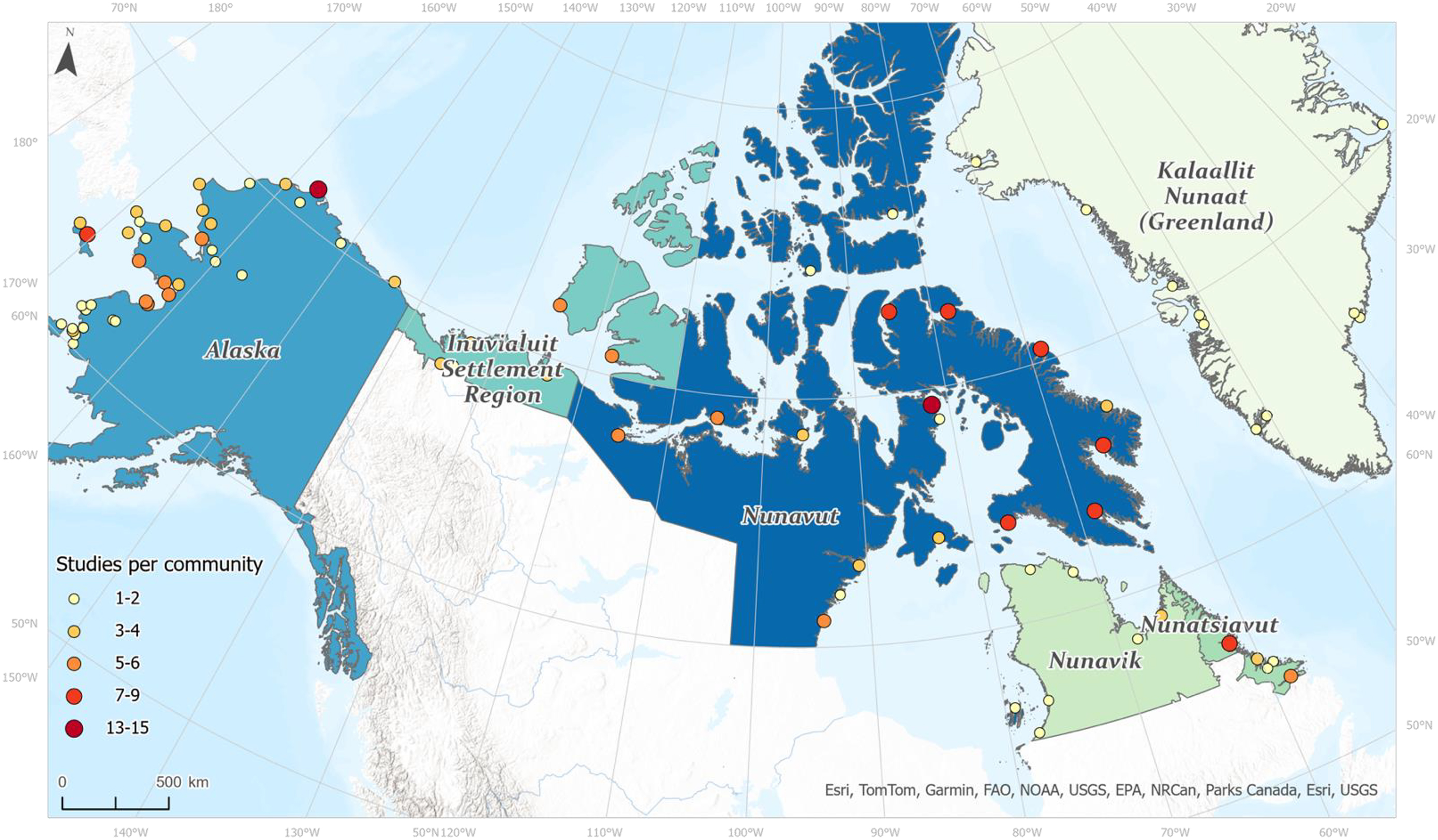
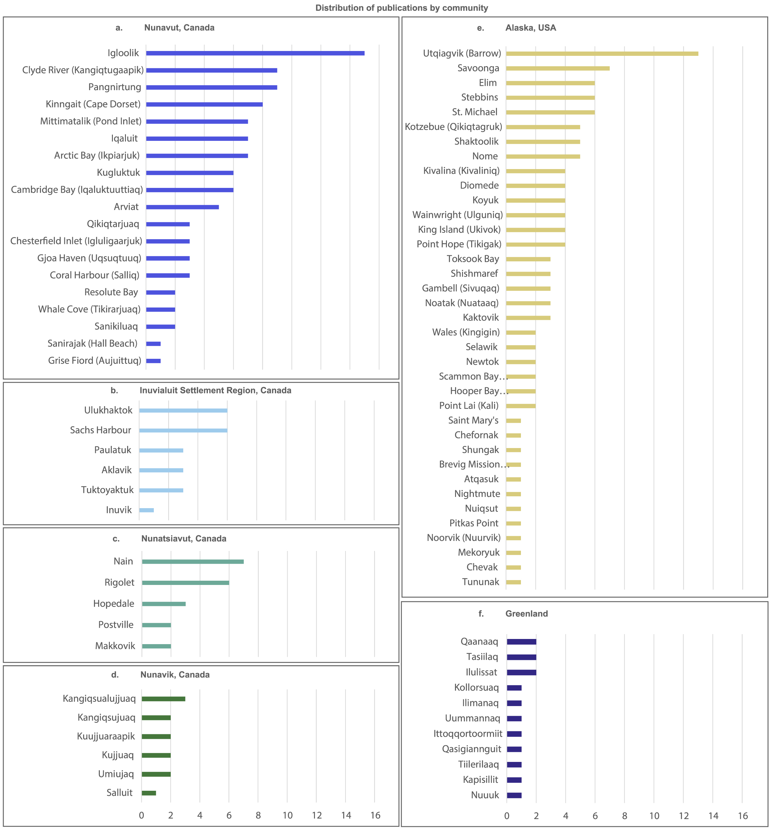
Inuit Knowledge, as recorded and presented in the publications reviewed, emerges from research that was based in 85 communities throughout Inuit Nunaat. This involves knowledge of place- and context-specific indicators that hold value at certain spatial and temporal scales of mobility on the land, as conveyed by participants in the related research projects. Our research reveals an uneven distribution of research intensity and related volume of publications reporting Inuit Knowledge of WWIC, with some communities and regions being disproportionately represented in the breadth of indicators presented in our review (Figs. 34). For example, 54% of all publications reviewed were associated with Nunavut, while Alaska was associated with 25%, and other Inuit regions were associated with between 7% and 11% of the reviewed publications. Inuit Knowledge from Igloolik, Nunavut and Utqiagvik (Barrow), Alaska was reported in 15 and 13 publications respectively, all other communities were associated with ≤ 9 publications (and the majority being represented in ≤ 6). There were limited publications stemming from Greenland and Nunavik, and less than 40% of WWIC indicators identified were associated with Greenland, Nunavik, and Nunatsiavut. While some research limitations listed in Section 2.4 may have impacted these numbers, a clear discrepancy remains. The implication of the uneven geographic variation in publications is that what we presented does not represent the full scope and context of WWIC indicators used in different Inuit regions and communities. The reported indicators likely reflect WWIC conditions experienced in regions/communities with a higher volume of associated publications. For example, out of all weather, water, and ice indicators identified in the publications we reviewed, 84% of ice, 86% of water, and 96% of weather indicators were described by Inuit in Nunavut. In contrast, 24% of ice, 36% of water, and 35% of weather indicators were described by Inuit in Greenland. This could imply that the indicators presented here bias towards those that are most relevant for Inuit in Nunavut. However, it is important to note that any communities not identified or regions and communities that were under-represented in our review may still use the extent of WWIC indicators in the results. As such, the WWIC indicators presented here cannot be considered comprehensive, but they can provide a broad baseline around which future research, monitoring, and/or forecasting can be developed. Such initiatives could aim to work with communities not identified through our review, or communities and regions that are under-represented (Petzold et al. 2020). Assessing the relevance of the WWIC indicators amongst Inuit communities and regions would help develop a more inclusive understanding of indicator use across Inuit Nunaat. Ultimately, it is essential to account for community-to-community and region-to-region differences as well as commonalities to achieve a more comprehensive understanding of regional dynamics and indicator relevance.

4.2. Interconnected assessments of WWIC

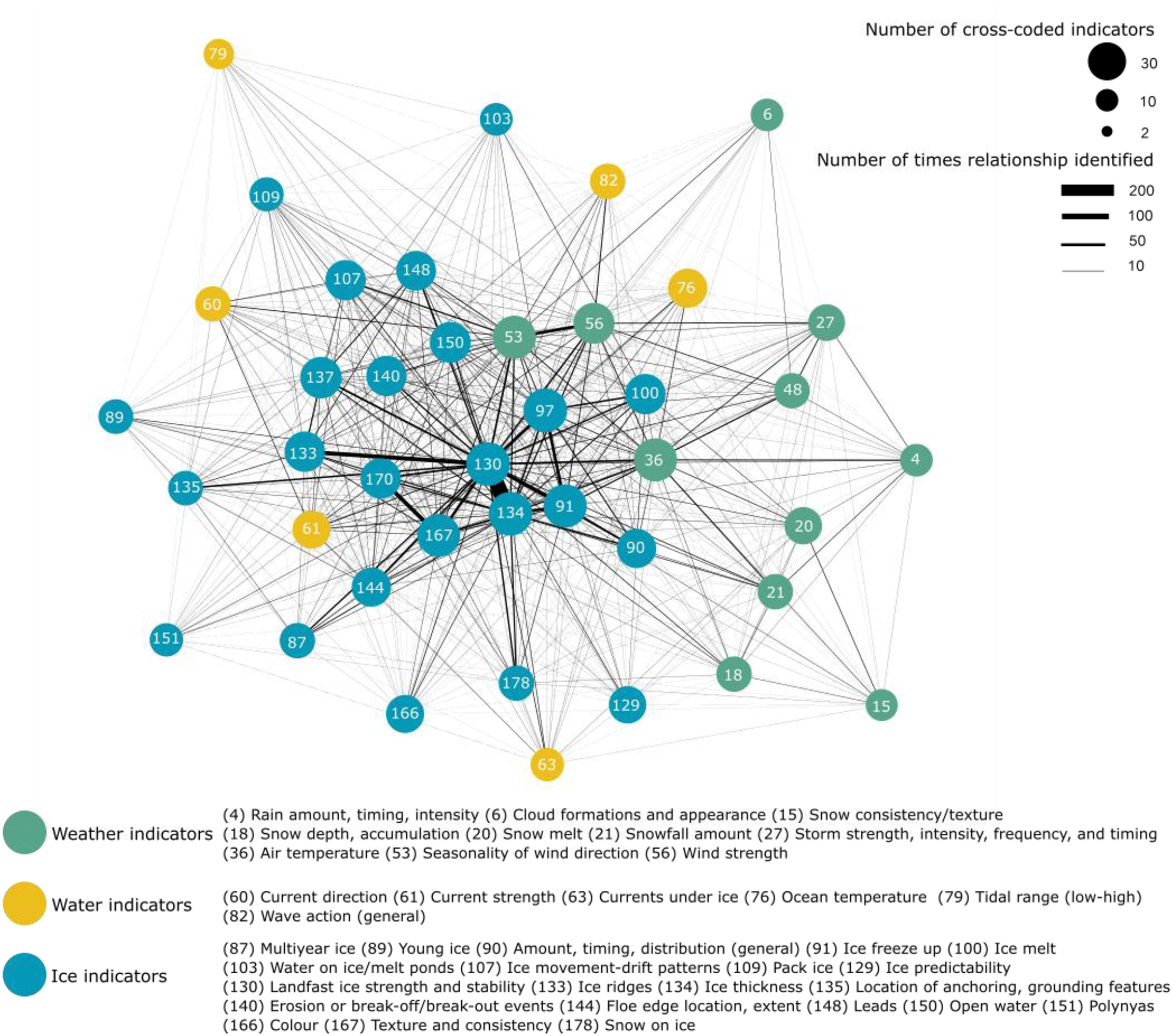
Weather, water, and ice conditions are time- and place- specific. The ice and water indicators identified through our review (Figs. 89) largely reflect the conditions of a platform upon which Inuit travel—one that connects people, animals, land, and sea (Aporta et al. 2018). Weather, in contrast, creates the conditions through which Inuit can or will travel, which in-turn influences the perceived quality of ice and water as a platform for travel (i.e., the conditions that may be encountered). Changes in weather, water, and ice are experienced first-hand and closely observed through day-to-day activities. In contrast, climate change has been framed as a more abstracted scientific concept (Ingold and Kurtilla 2000; Riedlinger and Berkes 2001). This abstraction could be linked to why a distinct “climate” indicator category was not identified. However, descriptions of predictive indicators and those associated with changing (reduced) predictability can convey where climate change impacts are being noticed more frequently. Relationships among weather, water, and ice indicators that once held true (trends over time) are no longer as predictable as they once were (indicative of changes to trends over time). These have the potential to be constructed as climate indicators. However, future research is warranted to explore this conceptualization further in collaboration with Inuit communities.
The importance of the WWIC indicators presented here is grounded in how Inuit perceive and understand their relationships with other conditions, which collectively influence travel safety and decision-making. Inuit Knowledge is the culmination of many generations of experiences within the Arctic climate system (Itchuaqiyaq 2023). While individual “components” of the climate system have direct impacts on travel safety, the ability to make decisions and understand the environment is predicated on understanding and assessing the system as whole. Cross-coding of indicators revealed an inherent relationality in how Inuit Knowledge of WWIC involves an integrated assessment of various conditions that influence specific indicators in causal, conditional, or predictive ways. Notably, these categories are not mutually exclusive, rather the nature of the relationship being described allows for causal, conditional, and/or predictive framing. For example, the season and the air temperature associated with rainfall amount, timing, and intensity can determine whether hazardous conditions will develop (conditional), while increased rainfall in the winter can lead to increased snowmelt, slush formation, and unstable ice conditions (causal, predictive).
For Inuit to understand WWIC conditions (and impacts to travel safety), it is not individual indicators alone but the interconnected relationships between elements of the climate system that must be interpreted (Nichols et al. 2004). This highlights the unique approach of collecting and passing on information as highly meaningful “environmental packages”, where the more relationships Inuit know, the more precise their observations and predictions can be (Oozeva et al. 2004). For example, rather than looking at ice strength and stability alone, Inuit are also assessing how conditions such as current speed and wind direction influence ice thickness, which is then contextualized further by the reason why Inuit are travelling in the first place (e.g., hunting on ice or by boat). These relationships are nuanced, context-based, and reflective of Inuit ways of knowing-being-doing-accounting relationally (McGrath 2018) which are deeply entrenched in processes of perceptually engaging with the environment (Ingold 2011). Such a perspective allows for in depth familiarity with WWIC situated according to—and contextualized by—the temporal and spatial scales of Inuit mobility on the land.
The relationships amongst WWIC indicators have been shifting, making traditional modes of prediction more difficult for Inuit to trust in the same way as in the past. Given this, Inuit are increasingly relying on information services to assess environmental conditions that might be encountered when travelling. This reliance is not replacing Inuit Knowledge, as information services can have limited value in certain contexts. Rather, information services are being evaluated and applied in conjunction with Inuit Knowledge (Hauser et al. 2023; Simonee et al. 2021; Wilson et al. 2021a). This dynamic mirrors efforts of other Indigenous groups globally (Balehegn et al. 2019; Chambers et al. 2019; Green et al. 2010; Masinde and Bagula 2011), where novel approaches to co-producing weather and climate information services are also being advanced with and for Indigenous communities (Barihaihi and Mwanzia 2017; Nyzadi et al. 2022; Plotz et al. 2017.

4.3. Gaps and insights for future research, monitoring, and forecasting

Monitoring and forecasting programs that provide information services use various environmental variables to create products and services that provide long- or short-range forecasts at local and regional scales. These forecasts rely on various data sources including conventional in-situ stations and satellite observing systems to produce predictive system models. Effective monitoring and forecasting in Inuit Nunaat are challenged by biases in in-situ station coverage, with the Arctic having notably sparse coverage when compared to more temperate latitudes (Cowtan and Way 2014; Johnson et al. 2015; Simonee et al. 2021). As such, the spatial and temporal coverage of many long-term assessment programs and long- and short-range forecasting products and services do not always correspond with WWIC conditions that impact Inuit living in coastal communities throughout Inuit Nunaat (Eicken et al. 2021; Fox et al. 2020; Stewart et al. 2020). Because of this, they may not capture where Inuit travel, phenomena of importance to Inuit, or Inuit approaches to observing the environment (Gearheard et al. 2010; Huntington et al. 2004).
Weather stations, if present, are typically located at community airports, whereas Inuit travel outside of their communities and can encounter conditions that do not correspond with weather station observations (Gearheard et al. 2010; Ljubibic and Carter 2022). Arctic coverage can also be entirely absent from critical information services. For example, the Canadian weather radar network has stations located exclusively in southern Canada, providing radar coverage only surrounding the locations of those stations (Voosen 2023). Some weather services provide hours-old or days-old information, while real-time information is critical for short-term planning and in the case of an emergency (Simonee et al. 2021). Similarly, certain information services are not available during the seasons that are most relevant for Inuit communities. For example, marine forecasts are only available during the marine shipping season, but that information would be very useful for communities year-round (Ljubicic and Carter 2022). Inadequate temporal and spatial coverage can be incredibly dangerous for people travelling on the land, where forecast accuracy can mean the difference between life and death (Way 2023, as cited in Sanders 2023). The focus of environmental monitoring and forecasting programs may not be representative of how Inuit observe and experience their local environments (Gearheard et al. 2010; Huntington et al. 2004). For example, while wind speed and direction may be monitored, the potential for blowing snow, or other indicators that can conditionally emerge might be more important for Inuit when making decisions related to safe travel.
The mandate driving the provision of information services may also misalign with Inuit uses of the environment. For example, while sea ice and the ocean act as a platform (or highway) for Inuit to access subsistence resources, sea ice information services provided by organizations such as the Canadian Ice Service (CIS) have been developed to meet their federal mandate to support safe shipping in Arctic waters by avoiding hazardous ice (Government of Canada 2022). Inuit have identified that sea ice charts are often inaccurate to local conditions, linked to the coarser spatial scale and an inadequate representation of ice thickness (concentration) or surface conditions (Ljubicic and Carter 2022; Segal et al. 2021; Wilson et al. 2021a). The conceptual tensions arising from how information services are designed and delivered can amplify the inaccessibility and inaccuracy of information services used by Inuit throughout Inuit Nunaat. It is essential to understand Inuit perspectives on the relevant indicators, appropriate temporal and spatial scales, and uses for WWIC information to effectively tailor information services to meet the needs of Inuit communities.
Despite the challenges identified above, WWIC information still plays an important role to support northern travel safety and decision making. Federal, open source, and industry provided online environmental services are just some, among many, tools that Inuit use to make decisions about when and where it is safe to travel (Laidler et al. 2011; Simonee et al. 2021; Wilson et al. 2021b). Currently, Inuit access these services through a range of apps and websites to use for their own purposes, while some Inuit experts skillfully translate relevant information into a local context to share over local radio or social media (Carter et al. 2023; Panikkar et al. 2018; Schiøtt et al. 2022; Simonee et al. 2021). Inuit Knowledge is essential to interpret this information, filling critical spatial and temporal gaps related to safety during sea ice travel (Laidler et al. 2011; Oozeva et al. 2004; Simonee et al. 2021; Wilson et al. 2021a). While WWIC information products and services may be increasingly used due to unpredictable weather and more time constraints on land travel, Inuit Knowledge is the “framework” through which information services are interpreted (Oozeva et al. 2004; Pennesi et al. 2012).
Given the holistic Inuit approach to understanding and assessing the environment, some environmental indicators used by Inuit may not be suited to systematic uptake and use in Western applications. This might include certain predictive indicators that involve sensory engagement with the landscape, or conditional indicators that emerge from the confluence of other conditions which could be time and place specific. However, the results of our review outline the breadth of WWIC indicators used by Inuit to assess travel safety in Inuit Nunaat, giving researchers and information service providers the opportunity to learn from these indicators and the relationality amongst them. 
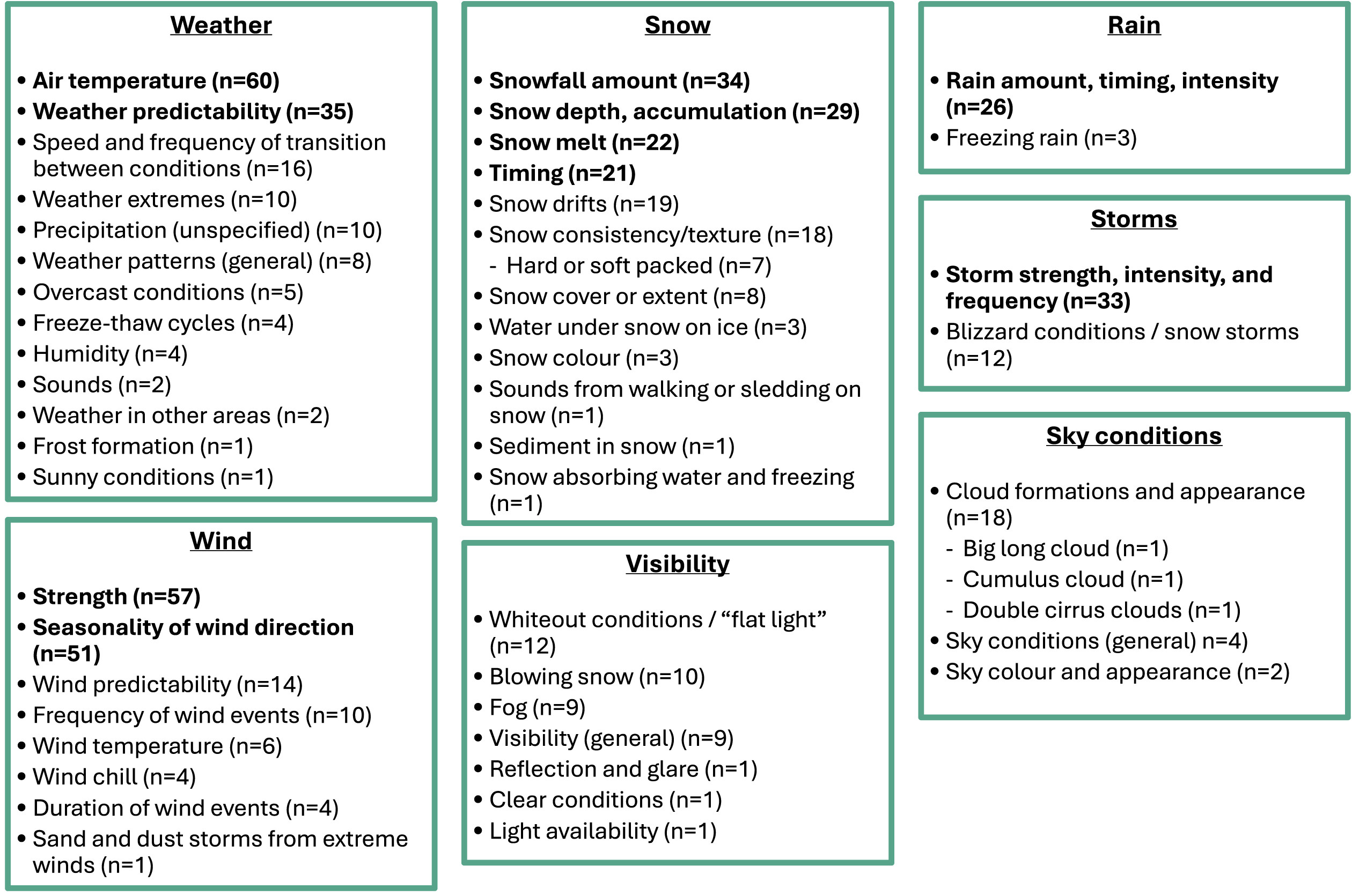
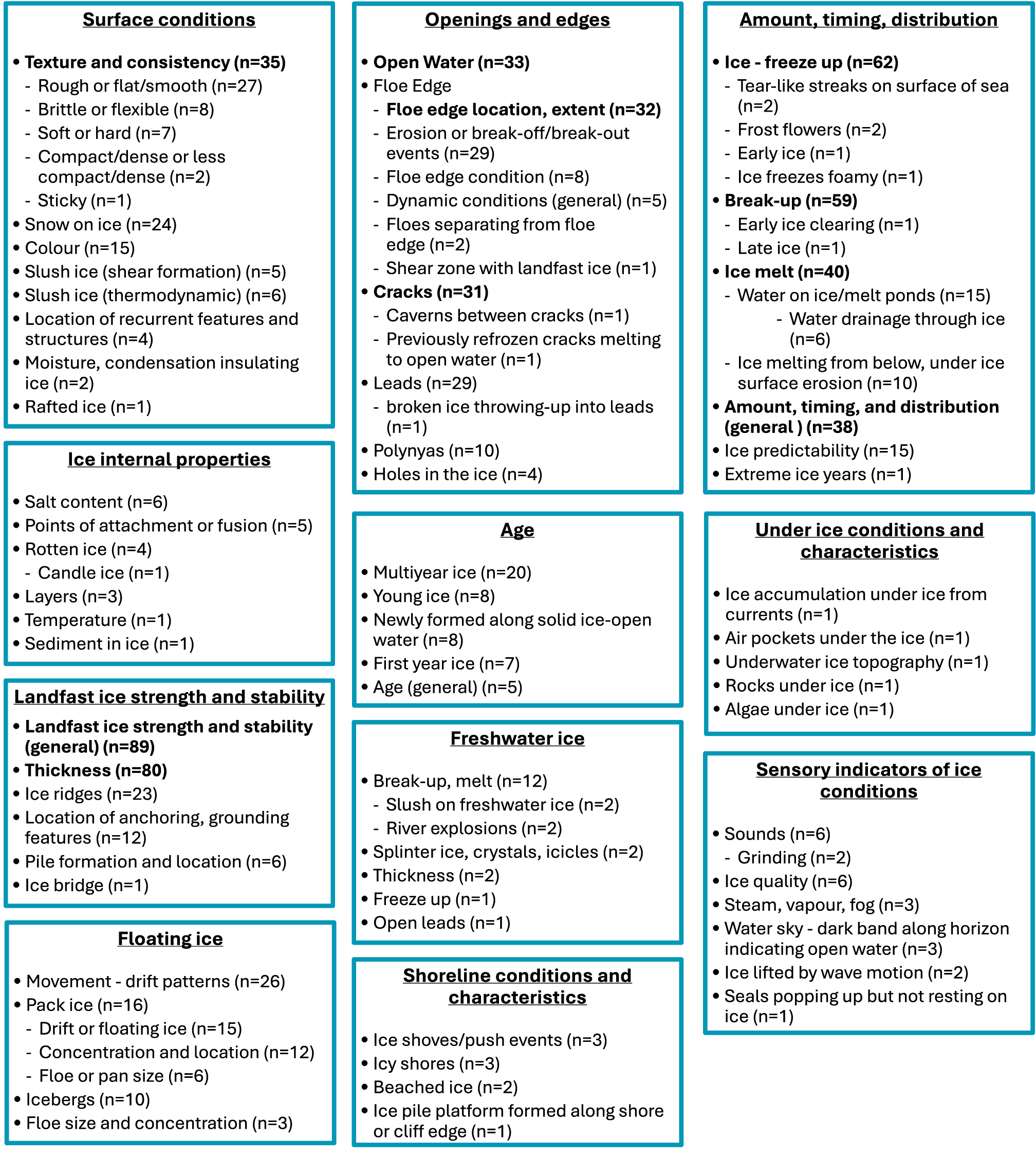
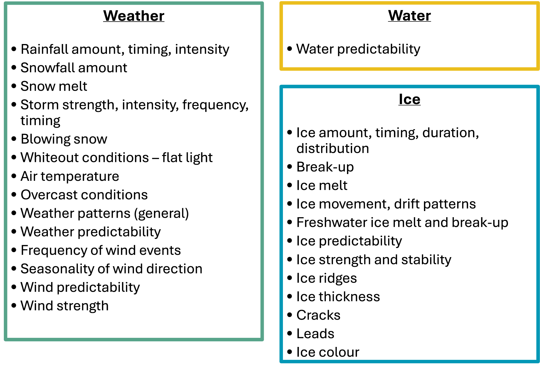
Table 2 details the top 10 weather, water, and ice indicators identified in the highest volume of publications. These indicators appear to be common across most regions, are critical to safe travel, and are already included (or could readily be included) in established monitoring programs to improve the relevance of information services accessed and used in Inuit communities.
Table 2.
Table 2. Top 10 weather, water, and ice indicators identified in the highest volume of publications as being used by Inuit in Canada, Alaska, and Greenland to support travel safety and decision making.
Weather indicatorsWater indicatorsIce indicators
air temperature (n = 60)current strength (n = 29)landfast ice strength and stability (general) (n = 89)
seasonality of wind direction (n = 51)wave action (general) (n = 24)ice thickness (n = 80)
wind strength (n = 51)ocean temperature (n = 17)ice break-up (n = 69)
weather predictability (n = 35)freshwater levels (n = 16)ice freeze-up (n = 62)
snowfall amount (n = 34)current direction (n = 16)ice melt (n = 40)
storm strength, intensity, and frequency (n = 33)currents under ice (n=15)ice amount, timing, duration, and distribution (general) (n = 38)
snow depth/accumulation (n = 29)tidal range (low-high) (n = 13)ice texture and consistency (n = 35)
rain amount, timing, and intensity (n = 26)tides (general) (n = 9)open water (n = 33)
snow timing (n = 21)tidal strength (n = 8)floe edge location and extent (n = 32)
snow melt (n = 21)bathymetry/depth (n = 7) and sea levels/coastal water levels (n = 7)cracks (n = 31)

Note: The total number of publications that described each indicator are noted. These indicators are common across most regions and are already included (or could readily be included) in established monitoring programs to improve the relevance of information services accessed and used in Inuit communities throughout Inuit Nunaat.

Practitioners can use our review to assess key indicators according to ease of prediction and degree of consistency across regions, which can help target the development of locally relevant research and information services. It will be critical to collaborate with communities to develop these programs. The results presented here come from various research contexts and can provide a starting off point for future collaborations aimed at increasing the accessibility of WWIC information services. This should include assessing the relevance and application of WWIC indicators through engagement with individual communities to better understand the extent of mobility on the land, indicator use/application, and what information is needed to support travel safety. The spatial/temporal application of indicators must also be assessed against currently available coverage, including those that are multi-scalar (e.g., wind) versus those that are location-specific (e.g., recurrent ice features such as polynyas or cracks).
Differing cultural perceptions of indicators must be addressed to effectively co-produce WWIC services. For example, Inuit notions of WWIC are not exclusively external environmental variables such as those favoured in Western environmental monitoring and forecasting. This difference in perception is exemplified by the Inuktitut term sila, which is commonly translated to “weather” in Western research. For Inuit, sila also embodies a permeating cultural and spiritual lifeforce which contextualizes human relations within broader ecological processes, including the weather (Leduc 2007). Reaching this level of understanding requires intentional engagement and conscious contextualization of Inuit Knowledge and experiences (Itchuaqiyaq 2023). Our review made evident the depth and specificity of Inuit terminology used to describe various WWIC conditions and processes. Accordingly, our results highlight the value of researchers and information service providers dedicating adequate time to learning—and translating—local terminology and associated conceptual meanings (whether in an Inuit language, English, or otherwise). This is critical for effective communication, and importantly, to avoid misunderstandings or misinterpretation. Doing so can help communicate the meaning of WWIC indicators that are used within and across various communities in Inuit Nunaat, and better asses their suitability for potential up-take into WWIC research, monitoring, and forecasting initiatives.
Inuit travel to hunt, harvest, visit other communities, access resources and connect with ancestral homelands, all of which is important to situate and contextualize the 163 unique indicators that arose from this scoping review (Aporta 2009; Cunsolo Willox et al. 2013; Davis et al. 2022). WWIC conditions are experienced in conjunction with ecological, social, cultural, political, and economic factors which collectively influence safe travel and access to the land (Moerlein and Carothers 2012). For example, weather, water, and ice conditions can influence the availability and distribution of wildlife and the ability for Inuit to safely access hunting and harvesting areas (Brinkman et al. 2016). However, the decision to travel may also be influenced by other socio-economic factors such as food security, the financial cost of a hunting trip, or the ability to take time off from work. In focusing on WWIC indicators, our review contributes to one aspect of this broader assessment. Thus, future research could consider WWIC indicators and their capacity to influence decision making in relation to other social, cultural, political, and economic considerations which impact access and safety.
While indicators can serve as a jumping off point in developing locally relevant research and information services, there are extensive co-production efforts that researchers and practitioners working in Inuit Nunaat can learn from to generate more accessible and usable information services. Moving beyond isolated WWIC indicators to address relational and socio-ecological underpinnings of observing the environment, Fox et al. (2020)   discuss the value of human-relevant environmental variables (HREVs). HREVs are complex synthesis variables that are used in conjunction with social factors to inform safe travel (Fox et al. 2020). Such an approach may help better translate the critical relationships that Inuit observe amongst various indicators, and the broader social, cultural, and economic determinants influencing travel safety. If co-developed, HREVs could become the focus of monitoring, forecasting, and prediction programs, or they may be used to help translate existing products and services to better communicate them in locally relevant terms. It is important to consider how WWIC indicators might be monitored relationally, where causal, conditional, or predictive indicator relationships are accounted for.
Pennesi et al. (2012) suggest establishing community-based weather hazard impact advisory groups as a format to bring together local and scientific weather knowledge and make information more accessible to communities. Creating such a group can help Western scientists connect directly with community members to understand how the information they produce is used, and how it may be better tailored to account for local experiences of travel hazards. Ultimately, this can support developing information services that combine Indigenous and Western forecasting, for example through a consensus approach or integrated probability forecasting (Nyzadi et al. 2022; Plotz et al. 2017). Co-producing information services in this way can increase local accessibility, relevance, and usefulness for Indigenous communities involved (Nyzadi et al. 2022).

5. Conclusions

For future research involving Inuit, or for monitoring and forecasting programs seeking community input or co-production of information services, it is important to understand the place- and context-specificity of Inuit Knowledge. It is also crucial to ensure adequate engagement with, and representation of communities (i.e., information users) in WWIC research and information service development/provision. Understanding Inuit experiences of their environment will be an important step to ensure future research, monitoring, and forecasting programs are locally-relevant and applicable to support the needs of communities throughout Inuit Nunaat. The breadth of indicators identified in this scoping review demonstrates the diversity of ways in which Inuit assess WWIC conditions to inform safe travel, including causal, conditional, and predictive uses of environmental indicators. Not all indicators used by Inuit are appropriate or even possible to apply in Western scientific research contexts. However, researchers and information service providers can draw on the breadth of indicators presented in our review, and especially those identified most frequently, to (re)evaluate or develop new approaches to working with communities to facilitate program development. Furthermore, a spatial-temporal analysis of indicator use/application could help situate and identify gaps in coverage that are important to address.
This scoping review emphasizes the importance of considering the context and meaning behind WWIC indicator use and application, particularly as Inuit Knowledge is locally situated, embedded, and experiential, which contrasts Western approaches to monitoring and forecasting. Our review also highlights the relationality amongst different WWIC indicators, whereby changes in one indicator can be related to changes in other indicators. These interconnections must be recognized to collectively assess WWIC conditions in terms of their impacts on safe travel and decision making (i.e., human-relevant environmental variables). Co-developing WWIC monitoring programs and/or information services with these interrelations in mind can enable reframing spatial and temporal scales of interest based on community defined place- and context-based indicators. Collective efforts to improve and tailor WWIC monitoring and services must prioritize relationships, whereby scientists need to recognize that the environmental changes they seek to understand are not taking place in an unknown frontier, but within a homeland. Therefore, efforts towards knowledge co-production require a conscious contextualization of the landscapes through which Inuit travel. Such landscapes are not an objective reality, but one whose nuances can only be understood through a collaborative and contextually perceptual engagement with Inuit homelands.

Acknowledgements

The authors wish to thank Sarah Stevenson for providing technical support in identifying relevant databases for the review. The broader project was funded by ArcticNet (a Network of Centres of Excellence Canada) and Crown-Indigenous Relations and Northern Affairs Canada (Climate Change Preparedness in the North Program). BB acknowledges support from a Social Sciences and Humanities Research Council (SSHRC) doctoral award. ECJO acknowledges support from a National Sciences and Engineering Research Council Discovery Grant (RGPIN-2018-05255).

References

AMAP. 2017. Snow, water, ice and permafrost in the Arctic (SWIPA) 2017. Arctic Monitoring and Assessment Programme (AMAP). 269p. Available from https://www.amap.no/documents/download/2987/inline.
AMAP. 2021. AMAP Arctic Climate Change Update 2021: Key Trends and Impacts. Arctic Monitoring and Assessment Programme (AMAP). 148p. Available from https://www.amap.no/documents/download/6890/inline.
Anastario M., Rink E., Reimer G.A., Peterson M. 2021. More-than-Human intimacies and traditional knowledge among hunting families in Northwest Greenland. Arctic Anthropology, 58(1): 54–65.
Aporta C. 2002. Life on the ice: understanding the codes of a changing environment. Polar Record, 38(207): 341–354.
Aporta C. 2004. Routes, trails and tracks: trail breaking among the Inuit of Igloolik. Études/Inuit/Studies, 28(2): 9–38.
Aporta C. 2009. The trail as home: Inuit and their Pan-Arctic network of routes. Human Ecology, 37(2): 131–146.
Aporta C. 2011. Shifting perspectives on shifting ice: documenting and representing Inuit use of the sea ice. Canadian Geographies / Géographies canadiennes, 55(1): 6–19.
Aporta C. 2016. Markers in space and time: reflections on the nature of place names as events in the Inuit approach to the territory. In Marking the Land: Hunter-Gatherer creation of meaning in their environment. Edited by W.A. Lovis, R. Whallon. Taylor and Francis. pp. 67–88.
Aporta C., Higgs E. 2005. Satellite culture: global positioning systems, Inuit wayfinding, and the need for a new account of technology. Current Anthropology, 46(6): 729–753.
Aporta C., Kane S.C., Chircop A. 2018. Shipping corridors through the Inuit homeland. Limn. Available from https://limn.it/articles/shipping-corridors-through-the-inuit-homeland/.
Balehegn M., Balehey S., Fu C., Liang W. 2019. Indigenous weather and climate forecasting knowledge among Afar pastoralists of north eastern Ethiopia: role in adaptation to weather and climate variability. Pastoralism, 9(1): 1–14.
Barber D.G., Asplin M.G., Raddatz R.L., Candlish L.M., Nickels S., Meakin S., et al. 2012. Change and variability in sea ice during the 2007–2008 Canadian International Polar Year program. Climatic Change, 115(1): 115–133.
Barihaihi M., Mwanzia J. 2017. Enhancing farmers’ resilience and adaptive capacity through access to usable weather information: A case study from Uganda. In Climate Change Adaptation in Africa Fostering Resilience and Capacity to Adapt, Edited by W.L. Filho, S. Belay, J. Kalangu, W. Menas, P. Munishi, K. Musiyiwaal. Springer, pp. 617–627.
Bates P. 2007. Inuit and scientific philosophies about planning, prediction, and uncertainty. Arctic Anthropology, 44(2): 87–100. Available from https://www.jstor.org/stable/40316694.
Bekryaev R.V., Polyakov I.V., Alexeev V.A. 2010. Role of polar amplification in long-term surface air temperature variations and modern Arctic warming. Journal of Climate, 23(14): 3888–3906.
Bell T., Briggs R., Bachmayer R., Li S. 2014. Augmenting Inuit knowledge for safe sea-ice travel—the SmartICE information system. 2014 Oceans—St. John's, OCEANS 2014.
Berkes F., Jolly D. 2001. Adapting to Climate change: social-ecological resilience in a Canadian Western Arctic community. Conservation Ecology, 5(2): 18.
Bishop B., Oliver E.C.J., Aporta C. 2021. Co-producing maps as boundary objects: bridging Labrador Inuit knowledge and oceanographic research. Journal of Cultural Geography, 39(1): 55–89.
Box J.E., Colgan W.T., Christensen T.R., Schmidt N.M., Lund M., Parmentier F.J.W., et al. 2019. Key indicators of Arctic climate change: 1971–2017. Environmental Research Letters, 14(4): 045010.
Brewster J., Neumann D., Ostertag S., Loseto L. 2016. Traditional Ecological Knowledge (TEK) at Shingle Point, YT: Observations on Changes in the Environment and Fish Populations   (3174; Canadian Technical Report of Fisheries and Aquatic Sciences).
Brinkman T.J., Hansen W.D., Chapin F.S.,Kofinas G.,BurnSilver S., Rupp T.S. 2016. Arctic communities perceive climate impacts on access as a critical challenge to availability of subsistence resources. Climatic Change 139(3-4):413–427.
Buijs C. 2010. Inuit perceptions of climate change in East Greenland. Études/Inuit/Studies, 34(1): 39–54.
Bunce A., Ford J., Harper S., Edge V. 2016. Vulnerability and adaptive capacity of Inuit women to climate change: A case study from Iqaluit, Natural Hazards, 83(3): 1419–1441.
Carmack E., Macdonald R. 2008. Water and ice-related phenomena in the coastal region of the Beaufort Sea: some parallels between native experience and western science. ARCTIC, 61(3): 265–280.
Carter N., Buttle C., Ljubicic G., Sinclair R., Paquette E. 2023. Nunavut: results of a community survey on environmental forecasting uses and needs. Available from https://straightupnorth.ca/community-wwic-uses-and-needs/.
Chambers L., Lui S., Plotz R., Hiriasia D., Malsale P., Pulehetoa-Mitiepo R., et al. 2019. Traditional or contemporary weather and climate forecasts: reaching Pacific communities. Regional Environmental Change, 19(5): 1521–1528.
Christie K.S., Hollmen T.E., Huntington H.P., Lovvorn J.R. 2018. Structured decision analysis informed by traditional ecological knowledge as a tool to strengthen subsistence systems in a changing Arctic. Ecology and Society, 23(4): 42.
Clark D.G., Ford J.D., Pearce T., Berrang-Ford L. 2016. Vulnerability to unintentional injuries associated with land-use activities and search and rescue in Nunavut, Canada. Social Science & Medicine, 169: 18–26.
Cowtan K., Way R.G. 2014. Coverage bias in the HadCRUT4 temperature series and its impact on recent temperature trends. Quarterly Journal of the Royal Meteorological Society, 140(683): 1935–1944.
Cunsolo Willox A. 2012. Lament for the Land: On the Impacts of Climate Change on Mental and Emotional Health and Well-Being in Rigolet, Nunatsiavut, Canada.
Cunsolo Willox A., Harper S.L., Edge V.L., Landman K., Houle K., Ford J.D. 2013. The land enriches the soul: on climatic and environmental change, affect, and emotional health and well-being in Rigolet, Nunatsiavut, Canada. Emotion, Space and Society, 6: 14–24.
Davis K., Ford J.D., Quinn C.H., Mosurska A., Flynn M.,   Harper S.L.,   I.H.A.C.C. Research Team, 2022. Shifting safeties and mobilities on the land in Arctic North America: A systematic approach to identifying the root causes of disaster. Sustainability, 14(12): 7061.
Dawson J., Carter N., van Luijk N., Parker C., Weber M., Cook A., et al. 2020. Infusing Inuit and local knowledge into the low impact shipping corridors: an adaptation to increased shipping activity and climate change in Arctic Canada. Environmental Science & Policy, 105: 19–36.
Derry K.W. 2011. New Risks, New strategies: Greenlandic Inuit responses to climate change Master's Thesis. Colorado State University.
Di Francesco J., Hanke A., Milton T., Leclerc L.M., Gerlach C., Kutz S., Kugluktuk Angoniatit Association, 2021. Documenting indigenous knowledge to identify and understand the stressors of Muskoxen (Ovibos moschatus) in Nunavut, Canada. ARCTIC, 74(4): 418–436.
Dowsley M., Gearheard S., Johnson N., Inksetter J. 2011. Should we turn the tent? Inuit women and climate change. Études/Inuit/Studies, 34(1): 151–165.
Druckenmiller M.L., Eicken H., George J.C. “Craig,”, Brower L. 2013. Trails to the whale: reflections of change and choice on an Iñupiat icescape at Barrow, Polar Geography, 36(1–2): 5–29.
Druckenmiller M.L., Eicken H., George J.C., Brower L. 2010. Assessing the shorefast ice: Iñupiat whaling trails off barrow, Alaska. In SIKU: Knowing Our Ice: Documenting Inuit Sea Ice Knowledge and Use. Edited by I. Krupnik, C. Aporta, S. Gearheard, G.J. Laidler, L.K. Holm. pp. 203–228.
Druckenmiller M.L., Eicken H., Johnson M.A., Pringle D.J., William C.C. 2009. Toward an integrated coastal sea-ice observatory: system components and a case study at Barrow, Alaska. Cold Regions Science and Technology, 56(2–3): 61–72.
Durkalec A., Furgal C., Skinner M.W., Sheldon T. 2014. Investigating environmental determinants of injury and trauma in the Canadian North. International Journal of Environmental Research and Public Health, 11(2): 1536–1548.
Durkalec A., Furgal C., Skinner M.W., Sheldon T. 2015. Climate change influences on environment as a determinant of indigenous health: relationships to place, sea ice, and health in an Inuit community. Social Science & Medicine, 136-137: 17–26.
Eicken H., Danielsen F., Sam J.M., Fidel M., Johnson N., Poulsen M.K., et al. 2021. Connecting top-down and bottom-up approaches in environmental observing. Bioscience, 71(5): 467–483.
Eicken H., Kaufman M., Krupnik I., Pulsifer P., Apangalook L., Apangalook P., et al. 2014. A framework and database for community sea ice observations in a changing Arctic: an Alaskan prototype for multiple users. Polar Geography, 37(1): 5–27.
Fienup-Riordan A. 1999. Yaqulget Qaillun Pilartat (What the Birds Do): Yup'ik Eskimo understanding of geese and those who study them. Arctic Journal, 52(1): 1. Available from https://www.jstor.org/stable/40512176.
Fienup-Riordan A. 2010. Yup'ik perspectives on climate change: “the world is following its people.” Études/Inuit/Studies, 34(1): 55–70.
Ford J.D., Bell T., St-Hilaire-Gravel D. 2010. Vulnerability of community infrastructure to climate change in Nunavut: A case study from Arctic Bay. In Community Adaptation and Vulnerability in Arctic Regions. Edited by G.K. Hovelsrud, B. Smit. pp. 107–130. Springer Netherlands.
Ford J.D., Clark D., Pearce T., Berrang-Ford L., Copland L., Dawson J., et al. 2019. Changing access to ice, land and water in Arctic communities. Nature Climate Change; London, 9(4): 335–339.
Ford J.D., McDowell G., Shirley J., Pitre M., Siewierski R., Gough W., et al. 2013. The dynamic multiscale nature of climate change vulnerability: an Inuit harvesting example. Annals of the Association of American Geographers, 103(5): 1193–1211. Available from https://www.jstor.org/stable/23485661.
Ford J.D., Pearce T., Gilligan J., Smit B., Oakes J. 2008. Climate change and hazards associated with ice use in northern Canada. The Geographical Journal, 174(4): 45–62.
Ford J.D., Smit B., Wandel J. 2006a. Vulnerability to climate change in the Arctic: A case study from Arctic Bay, Canada. Global Environmental Change, 16(2):145–160.
Ford J.D., Smit B., Wandel J., MacDonald J. 2006b. Vulnerability to climate change in Igloolik, Nunavut: what we can learn from the past and present. Polar Record, 42(2): 127–138.
Fox S., Qillaq E., Angutikjuak I., Tigullaraq D.J., Kautuk R., Huntington H., et al. 2020. Connecting understandings of weather and climate: steps towards co-production of knowledge and collaborative environmental management in Inuit Nunangat. Arctic Science, 6(3): 267–278.
Furgal C.M., Innes S., Kovacs K.M. 2002. Inuit spring hunting techniques and local knowledge of the ringed seal in Arctic Bay (Ikpiarjuk), Nunavut. Polar Research, 21(1): 1–16.
Gadamus L., Raymond-Yakoubian J. 2015. A Bering Strait indigenous framework for resource management: respectful seal and walrus hunting. Arctic Anthropology, 52(2): 87–101.
Gearheard S., Matumeak W., Angutikjuaq I., Maslanik J., Huntington H.P., Leavitt J., et al. 2006. “It's not that simple”: A collaborative comparison of sea ice environments, their uses, observed changes, and adaptations in Barrow, Alaska, USA, and Clyde River, Nunavut, Canada. AMBIO: A Journal of the Human Environment, 35(4): 203–211. Available from https://www.jstor.org/stable/4315720.
Gearheard S., Pocernich M., Stewart R., Sanguya J., Huntington H.P. 2010. Linking Inuit knowledge and meteorological station observations to understand changing wind patterns at Clyde River, Nunavut. Climatic Change, 100(2): 267–294.
Glaser B.G. 1965. The constant Comparative method of qualitative analysis. Social Problems, 12(4): 436–445.
Glaser B.G., Strauss A.L. 2017. The discovery of grounded theory: strategies for qualitative research. Routledge.
Green D., Jack B., Tapim A. 2010. Indigenous Australians’ knowledge of weather and climate. Climatic Change, 100: 337.
Hanke A.N., Angohiatok M., Leclerc L.M., Adams C., Kutz S. 2021. A Caribou decline foreshadowed by Inuit in the Central Canadian Arctic: A retrospective analysis. ARCTIC, 74(4): 437–455.
Harper S.L., Edge V.L., Ford J., Cunsolo Willox A., Wood M., McEwen S.A. 2015. Climate-sensitive health priorities in Nunatsiavut, Canada. BMC Public Health [Electronic Resource], 15(1): 1–18.
Hauser D.D., Glenn R.T., Lindley E.D., Pikok K.K., Heeringa K., Jones J., et al. 2023. Nunaaqqit Savaqatigivlugich—Working with communities: evolving collaborations around an Alaska Arctic observatory and knowledge hub. Arctic Science, 9(3): 1–22.
Hauser D.D., Whiting A.V., Mahoney A.R., Goodwin J., Harris C., Schaeffer R.J, et al. 2021. Co-production of knowledge reveals loss of Indigenous hunting opportunities in the face of accelerating Arctic climate change. Environmental Research Letters, 16(9): 095003.
Henri D.A., Carter N.A., Irkok A., Nipisar S., Emiktaut L., Saviakjuk B., et al. 2020. Qanuq ukua kanguit sunialiqpitigu? (What should we do with all of these geese?) Collaborative research to support wildlife co-management and Inuit self-determination. Arctic Science, 6(3): 173–207.
Henshaw A. 2009. Sea ice: The sociocultural dimensions of a melting environment in the Arctic. In Anthropology and Climate Change: From encounters to actions. Edited by S.A. Crate, M. Nuttall. Left Coast Press, Inc. pp. 153–165.
Herman-Mercer N., Schuster P., Maracle K. 2011. Indigenous observations of climate change in the Lower Yukon River Basin, Alaska. Human Organization, 70(3): 244–252.
Hirsch R., Furgal C., Hackett C., Sheldon T., Bell T., Angnatok D., et al. 2017. Going off, growing strong: A program to enhance individual youth and community resilience in the face of change in Nain, Nunatsiavut. Études/Inuit/Studies, 40(1): 63–84.
Huntington H.P., Binder R., Comeau R., Holm L.K., Metcalf V., Oshima T., et al. 2020. Crossroads of continents and modern boundaries: an introduction to Inuit and Chukchi experiences in the Bering Strait, Beaufort Sea, and Baffin Bay. Water. 12(6):1808.
Huntington H.P., Callaghan T., Fox S., Krupnik I. 2004. Matching traditional and scientific observations to detect environmental change: A discussion on arctic terrestrial ecosystems. AMBIO: A Journal of the Human Environment. 33: 18–23. Available from https://www.jstor.org/stable/25094583.
Huntington H.P., Gearheard S., Holm L.K. 2010. The power of multiple perspectives: behind the scenes of the Siku–Inuit–Hila project. In SIKU: Knowing Our Ice. Edited by I. Krupnik, C. Aporta, S. Gearheard, G.J. Laidler, L.K. Holm. Springer Netherlands. (pp. 257–274).
Huntington H.P., Gearheard S., Holm L.K., Noongwook G., Opie M., Sanguya J. 2016a. Sea ice is our beautiful garden: indigenous perspectives on sea ice in the Arctic. In Sea Ice. Edited by D.N. Thomas. John Wiley and Sons, Ltd. (pp. 583–599).
Huntington H.P., Quakenbush L.T., Nelson M. 2016b. Effects of changing sea ice on marine mammals and subsistence hunters in northern Alaska from traditional knowledge interviews. Biology Letters. 12(8): 20160198.
Huntington H.P., Quakenbush L.T., Nelson M. 2017. Evaluating the effects of climate change on indigenous marine mammal hunting in Northern and Western Alaska using traditional knowledge. Frontiers in Marine Science, 4: 1–17.
Ingold T. 2011. The perception of the environment: Essays on livelihood, dwelling and skill. Routledge, Taylor and Francis Group.
Ingold T., Kurtilla T. 2000. Perceiving the environment in Finnish Lapland. Body & Society, 6(3–4): 183–196.
Inuit Circumpolar Council-Canada. 2014. The sea ice never stops: circumpolar Inuit reflections on sea ice use and shipping in Inuit Nunaat. Available from https://secureservercdn.net/104.238.71.250/hh3.0e7.myftpupload.com/wp-content/uploads/Sea-Ice-Never-Stops-Final.pdf.
Inuit Tapiriit Kanatami. 2019. National Inuit Climate Change Strategy. Available from https://www.itk.ca/wp-content/uploads/2019/07/ITK_Climate-Change-Strategy_English.pdf.
Inuksuk A. 2011. On the nature of sea ice around Igloolik. The Canadian Geographer / Le Géographe canadien 55(1): 36–41.
Itchuaqiyaq C.U. 2023. “When the sound is frozen”: extracting climate data from traditional Inuit narratives. In Technical Communication for Environmental Action. Edited by S.D. Williams. pp. 19–38.
Johansson K. 2008. Inuit safety culture and its potential influence on management practices in Auyuittuq National Park, Nunavut. Master's Thesis. University of Manitoba.
Johansson K., Manseau M. 2012. Inuit safety culture and its relevance to safety management in Auyuittuq National Park. Society & Natural Resources, 25(2): 176–190.
Johnson N., Alessa L., Behe C., Danielsen F., Gearheard S., Gofman-Wallingford V., et al. 2015. The contributions of community-based monitoring and traditional knowledge to Arctic observing networks: reflections on the State of the field. ARCTIC, 68: 1–13.
Kaiser B.A., Hoeberechts M., Maxwell K.H., Eerkes-Medrano L., Hilmi N., Safa A., et al. 2019. The importance of connected ocean monitoring knowledge systems and communities. Frontiers in Marine Science, 6: 309.
Kenney M.A., Janetos A.C., Lough G.C. 2016. Building an integrated U.S. National Climate Indicators System. Climatic Change, 135(1): 85–96.
Khalil H., Bennett M., Godfrey C., McInerney P., Munn Z., Peters M. 2020. Evaluation of the JBI scoping reviews methodology by current users. International Journal of Evidence-Based Healthcare, 18(1): 95–100.
Laidler G.J., Elee P. 2008. Human geographies of sea ice: freeze/thaw processes around Cape Dorset, Nunavut, Canada. Polar Record, 44(1): 51–76.
Laidler G.J., Ikummaq T. 2008. Human geographies of sea ice: freeze/thaw processes around Igloolik, Nunavut, Canada. Polar Record, 44(2): 127–153.
Laidler G.J., Dialla A., Joamie E. 2008. Human geographies of sea ice: freeze/thaw processes around Pangnirtung, Nunavut, Canada. Polar Record, 44(4): 335–361.
Laidler G.J., Elee P., Ikummaq T., Joamie E., Aporta C. 2010. Mapping Inuit Sea ice knowledge, use, and change in Nunavut, Canada (Cape Dorset, Igloolik, Pangnirtung). In SIKU: Knowing Our Ice(pp. 45–80). Edited by I. Krupnik, C. Aporta, S. Gearheard, G.J. Laidler, L. Kielsen Holm. Springer Netherlands.
Laidler G.J., Ford J.D., Gough W.A., Ikummaq T., Gagnon A.S., Kowal S., et al. 2009. Travelling and hunting in a changing Arctic: assessing Inuit vulnerability to sea ice change in Igloolik, Nunavut. Climatic Change, 94(3–4): 363–397.
Laidler G.J., Hirose T., Kapfer M., Ikummaq T., Joamie E., Elee P. 2011. Evaluating the Floe Edge service: how well can SAR imagery address Inuit community concerns around sea ice change and travel safety? Canadian Geographies / Géographies canadiennes, 55(1): 91–107.
Ljubicic G.J., Carter N.A. 2022. Weather and society in Inuit Nunangat: user needs, service provider efforts, and opportunities for the future (Weather and Society)   [Proceedings of the Weather and Society online workshop focused on Inuit Nunangat]. McMaster University. Available from https://straightupnorth.files.wordpress.com/2022/10/weather-society_oct2022-report.pdf.
Ljubicic G.J., Carter N.A. 2023. Weather and society: tailoring weather, water, ice, and climate services to northern community needs (Weather and Society)    [Summary of the Weather and Society side meeting hosted at the ArcticNet Annual Scientific Meeting]. McMaster University. Available from https://straightupnorth.files.wordpress.com/2023/08/weather-society_2023-report.pdf.
Mahoney A., Gearheard S., Oshima T., Qillaq T. 2009. Sea ice thickness measurements from a community-based observing network. Bulletin of the American Meteorological Society, 90(3): 370–378.
Masinde M., Bagula A. 2011. ITIKI: bridge between African indigenous knowledge and modern science of drought prediction. Knowledge Management for Development Journal, 7(3): 274–290.
McGrath J.T. 2018. The Qaggiq Model: toward a theory of Inuktut knowledge renewal. Nunavut Arctic College Media.
Mercer L., Whalen D., Lim M., Cockney K., Cormier S., Irish C., Mann P.J. 2023. Towards more inclusive and solution orientated community-based environmental monitoring. Environmental Research Letters, 18, 064003.
Moerlein K.J., Carothers C. 2012. Total environment of change: impacts of climate change and social transitions on subsistence fisheries in Northwest Alaska. Ecology and Society, 17(1): art10.
Nichols T., Berkes F., Jolly D., Snow N.B., The Community of Sachs Harbour (N.W.T.). 2004. Climate change and sea ice: local observations from the Canadian western Arctic. ARCTIC 57(1): 68–79.
Nyzadi E., Werners S., Beisbroek R., Ludwig F. 2022. Towards weather and climate services that integrate indigenous and scientific forecasts to improve forecast reliability and acceptability in Ghana. Environmental Development 42: 100698.
Oozeva C., Noongwook C., Noongwook G., Alowa C., Krupnik I. 2004. Watching ice and weather our way: Sikumengllu eslamengllu esghapalleghput. Edited by I. Krupnik, H.P. Huntington, C. Koonooka, G. Noongwook. Arctic Studies Center, Smithsonian Institution.
Panikkar B., Lemmond B., Else B., Murray M. 2018. Ice over troubled waters: navigating the Northwest Passage using Inuit knowledge and scientific information. Climate Research, 75(1): 81–94.
Pearce T., Smit B., Duerden F., Ford J.D., Goose A., Kataoyak F. 2010. Inuit vulnerability and adaptive capacity to climate change in Ulukhaktok, Northwest Territories, Canada. Polar Record, 46(2): 157–177.
Pennesi K., Arokium J., McBean G. 2012. Integrating local and scientific weather knowledge as a strategy for adaptation to climate change in the Arctic. Mitigation and Adaptation Strategies for Global Change, 17(8): 897–922.
Peters M.D.J., Godfrey C.M., Khalil H., McInerney P., Parker D., Soares C.B. 2015. Guidance for conducting systematic scoping reviews. International Journal of Evidence-Based Healthcare, 13(3): 141–146.
Peters M.D.J., Marnie C., Tricco A.C., Pollock D., Munn Z., Alexander L., et al. 2020. Updated methodological guidance for the conduct of scoping reviews. JBI Evidence Synthesis, 18(10): 2119–2126.
Petzold J., Andrews N., Ford J.D., Hedemann C., Postigo J.C. 2020. Indigenous knowledge on climate change adaptation: A global evidence map of academic literature. Environmental Research Letters, 15(11): 113007.
Plotz R.D., Chambers L.E., Finn C.K. 2017. The Best of Both Worlds: A Decision-Making Framework for Combining Traditional and Contemporary Forecast Systems. Journal of Applied Meteorology and Climatology 56(8):2377–2392.
Prno J., Bradshaw B., Wandel J., Pearce T., Smit B., Tozer L. 2011. Community vulnerability to climate change in the context of other exposure-sensitivities in Kugluktuk, Nunavut. Polar Research, 30(1): 7363.
Rantanen M., Karpechko A.Y., Lipponen A., Nordling K., Hyvärinen O., Ruosteenoja K., et al. 2022. The Arctic has warmed nearly four times faster than the globe since 1979. Communications Earth & Environment, 3(1): 168.
Rathwell K.J. 2020. “She is transforming:” inuit artworks reflect a cultural response to Arctic sea ice and climate change. ARCTIC, 73(1): 67–80.
Riedlinger D., Berkes F. 2001. Contributions of traditional knowledge to understanding climate change in the Canadian Arctic. Polar Record, 37(203): 315–328.
Rode K.D., Voorhees H., Huntington H.P., Durner G.M. 2021. Iñupiaq knowledge of polar bears (Ursus maritimus) in the Southern Beaufort Sea, Alaska. ARCTIC, 74(3): 239–257.
Sanders R. 2023. Weather stations are sparse in Labrador. The gaps can be a matter of ‘life or death’. CBC Radio—What on Earth, 19 February, 2023. Available from https://www.cbc.ca/radio/whatonearth/weather-data-gaps-life-or-death-1.6751883.
Sawatzky A., Cunsolo A., Shiwak I., Flowers C., Jones-Bitton A., Gillis D., et al. 2021. “It depends…”: Inuit-led identification and interpretation of land-based observations for climate change adaptation in Nunatsiavut, Labrador. Regional Environmental Change, 21(2): 54.
Schiøtt S., Tejsner P., Rysgaard S. 2022. Inuit and local knowledge on the marine ecosystem in Ilulissat Icefjord, Greenland. Human Ecology, 50(1): 167–181.
Schmidt J., Hausner V., Monz C. 2021. Building adaptive capacity in a changing Arctic by use of technology. Ecology and Society, 26(4).
Segal R.A., Scharien R.K., Duerden F., Tam C.L. 2021. The best of both worlds: connecting remote sensing and arctic communities for safe sea ice travel. ARCTIC, 73(4): 461–484.
Simonee N., Alooloo J., Carter N.A., Ljubicic G., Dawson J. 2021. Sila qanuippa? (How's the weather?): integrating Inuit Qaujimajatuqangit and environmental forecasting products to support travel safety around Pond Inlet, Nunavut in a changing climate. Weather, Climate, and Society, 13: 933–962.
Stewart E.J., Liggett D., Lamers M., Ljubicic G., Dawson J., Thoman R., et al. 2020. Characterizing polar mobilities to understand the role of weather, water, ice and climate (WWIC) information. Polar Geography, 43(2–3): 95–119.
Tremblay M., Furgal C., Lafortune V., Larrivée C., Savard J.P., Barrett M., et al. 2006. Communities and ice: bringing together traditional and scientific knowledge. In Climate change: linking traditional and scientific knowledge. Edited by R. Riewe, J. Oakes. pp. 123–138.
Tricco A.C., Lillie E., Zarin W., O'Brien K.K., Colquhoun H., Levac D., et al. 2018. PRISMA extension for scoping reviews (PRISMA-ScR): checklist and explanation. Annals of Internal Medicine, 169(7): 467–473.
Voosen P. 2023. Dwinding weather data leave Canadians in the cold. Science, 3(6636): 968–969.
Weatherhead E., Gearheard S., Barry R.G. 2010. Changes in weather persistence: insight from Inuit knowledge. Global Environmental Change, 20(3): 523–528.
Wilson K., Arreak A.,   Bell T., Ljubicic G.,   Sikumiut Committee, 2021a. The Mittimatalik siku asijjipallianinga (sea ice climate atlas): how Inuit knowledge, earth observations and sea ice charts can fill IPCC climate knowledge gaps. Frontiers in Climate, 3.
Wilson K., Arreak A., Itulu J., Ljubicic G.J., Bell T., Sikumiut Community Management Committee, 2021b. “When we're on the ice, all we have is our Inuit Qaujimajatuqangit”: mobilizing Inuit knowledge as a sea ice safety adaptation strategy in Mittimatalik, Nunavut. ARCTIC, 74(4): 525–549.
Worden E., Pearce T., Gruben M., Ross D., Kowana C., Loseto L. 2020. Social-ecological changes and implications for understanding the declining beluga whale (Delphinapterus leucas) harvest in Aklavik, Northwest Territories. Arctic Science, 6(3): 229–246.

Supplementary material

Supplementary Material 1 (PDF / 111 KB).
Supplementary Material 2 (PDF / 441 KB).

Information & Authors

Information

Published In

cover image FACETS
FACETS
Volume 10January 2025
Pages: 1 - 25
Editor: Christopher Sergeant

History

Received: 3 June 2024
Accepted: 5 October 2024
Version of record online: 7 February 2025

Data Availability Statement

Data generated during this study are provided in full within the published article and the supplementary materials. Data analysed during this study are available from the corresponding author upon reasonable request.

Key Words

  1. environmental indicators
  2. climate change
  3. travel safety
  4. Inuit Knowledge
  5. climate services
  6. weather monitoring

Sections

Subjects

Authors

Affiliations

Department of Oceanography, Dalhousie University, Halifax, NS, Canada
Author Contributions: Conceptualization, Data curation, Formal analysis, Investigation, Methodology, Validation, Visualization, Writing – original draft, and Writing – review & editing.
Department of Geography and Environmental Studies, Carleton University, Ottawa, ON, Canada
Author Contributions: Data curation, Investigation, Validation, and Writing – review & editing.
School of Earth, Environment and Society, McMaster University, Hamilton, ON, Canada
Author Contributions: Conceptualization, Methodology, and Writing – review & editing.
School of Earth, Environment and Society, McMaster University, Hamilton, ON, Canada
Author Contributions: Conceptualization, Funding acquisition, Methodology, Project administration, Supervision, and Writing – review & editing.
Department of Oceanography, Dalhousie University, Halifax, NS, Canada
Author Contributions: Visualization and Writing – review & editing.
World Maritime University, Malmo, Sweden
Author Contribution: Writing – review & editing.

Author Contributions

Conceptualization: GL, BB, NC
Data curation: BB, EP
Formal analysis: BB
Funding acquisition: GL
Investigation: BB, EP
Methodology: BB, NC, GL
Project administration: GL
Supervision: GL
Validation: BB, EP
Visualization: BB, ECJO
Writing – original draft: BB
Writing – review & editing: BB, EP, NC, GL, ECJO, CA

Competing Interests

The authors declare there are no competing interests.

Funding Information

National Sciences and Engineering Research Council Discovery Grant
ArcticNet ArcticNet (a Network of Centres of Excellence Canada)
Crown-Indigenous Relations and Northern Affairs Canada (Climate Change Preparedness in the North Program)
Social Sciences and Humanities Research Council (SSHRC) Doctoral Fellowship

Metrics & Citations

Metrics

Other Metrics

Citations

Cite As

Export Citations

If you have the appropriate software installed, you can download article citation data to the citation manager of your choice. Simply select your manager software from the list below and click Download.

There are no citations for this item

View Options

View options

PDF

View PDF

Media

Tables

Media

Share Options

Share

Share the article link

Share on social media